WEATHER-TRAFFIC UPDATE: Delays increase as cloudy evening commute commences
ATLANTA FORECAST
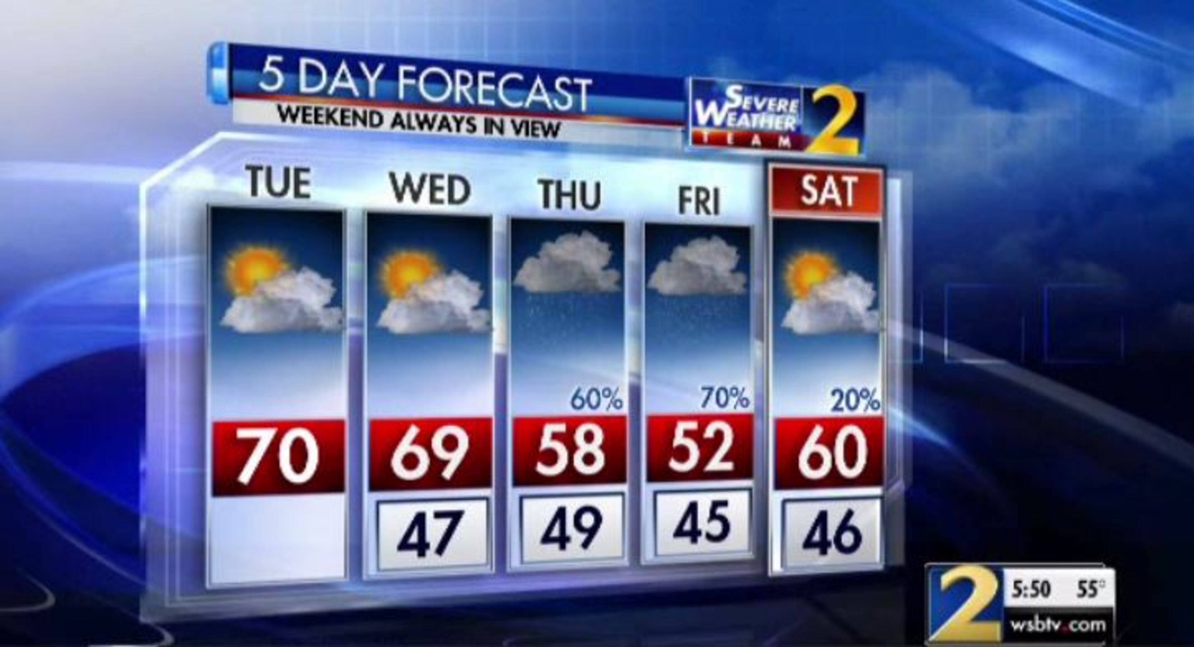
Tuesday: High: 70
Tuesday night: Low: 47
Wednesday: High: 69
» For a detailed forecast, visit The Atlanta Journal-Constitution weather page.
The Downtown Connector and Northern Perimeter have become congested because of wrecks as construction continues to slow down back roads, according to the WSB 24-hour Traffic Center.
All the while, the sun peeks through a light layer of clouds, slowly warming Atlanta into the upper 60s. The sunshine should help to warm Atlanta to a high of 70 degrees this afternoon, likely the warmest temperature the city will see all week.
Temps are in the 60s to around 70 degrees now in #ATL... but much colder weather is coming later this week.@GlennBurnsWSB & @BradNitzWSB are updating the forecast live on Channel 2 starting at 4. @wsbtv
— Brian Monahan, WSB (@BMonahanWSB) October 23, 2018
A multivehicle wreck on I-285 East at Moreland Avenue had all lanes blocked in DeKalb County, according to the WSB 24-hour Traffic Center. The wreck has cleared, but delays remain heavy.
#GRIDLOCKALERT All lanes re-opened I-285/eb (Outer Loop) w of Moreland (exit 53) - big delays before I-75. Left lane still blocked I-285/wb in area, brief delays there. #ATLtraffic https://t.co/2hvjWkI3bV pic.twitter.com/2NkCJLJybu
— AJC WSB Traffic (@ajcwsbtraffic) October 23, 2018
A wreck on the Downtown Connector is backed up because of a wreck near I-20 that is blocking a southbound left lane, the Traffic Center reported.
There are some minor construction-related delays across other parts of metro Atlanta, the Traffic Center reported.
Downtown, crews are at work on Peachtree Street and on Northside Drive, acccording to the Traffic Center. A right northbound lane is blocked on Peachtree Street past Deering Road. On Northside Drive, only one right southbound lane is open at Magnolia Street.
Temps are in the upper 60s now in #ATL -- but highs will not get out of the 40s for parts of north Georgia by the end of the week! @BradNitzWSB is updating the forecast live at 5 on @wsbtv.
— Brian Monahan, WSB (@BMonahanWSB) October 23, 2018
Metro Atlanta should see more chilly, dry weather before even cooler temperatures and rain clouds slide into the state behind Hurricane Willa.
Willa is expected to hit the west-central coast of Mexico later Tuesday, according to Channel 2. Georgia likely won’t feel the effects of the storm until Thursday afternoon.
“The moisture from it is going to get caught up and is being pushed toward the Southeast, so it’s going to be moving into our area,” Channel 2 meteorologist Karen Minton said. “We’re going to tap into some of that moisture by the end of the week, and it’s going to set us up for some rain.”
Major Hurricane Willa will make landfall on the Mexican Pacific Coast today then spread rain across Georgia later this week.
— Brad Nitz (@BradNitzWSB) October 23, 2018
I'll have a look at the storms impacts live on @wsbtv at 4:25 pm. pic.twitter.com/1yNMRGWrSo
High pressure remains in place Wednesday, she said, but the remnants of Willa will start to work together with that weather system when the storm moves through.
“It keeps us cool, because we've got a wedge of high pressure bringing the cooler, dry air in here,” Minton said. “Then the moisture overrides on top of that. We end up with the gray clouds and cool temperatures.”
The rain chance ramps up to 60 percent Thursday and 70 percent Friday before drying out over the weekend, according to the latest forecast from Channel 2. As rain increases, light drizzle, mist and showers are expected in North Georgia.
Morning lows are expected to dip into the mid-40s by the end of the week, with afternoon highs in the low 50s.
» For updated traffic information, listen to News 95.5 and AM 750 WSB and follow @ajcwsbtraffic on Twitter.
» Download The Atlanta Journal-Constitution app for weather alerts on-the-go.