WEATHER-TRAFFIC UPDATE: Heaviest storms staying put on metro’s edges during evening commute
ATLANTA FORECAST
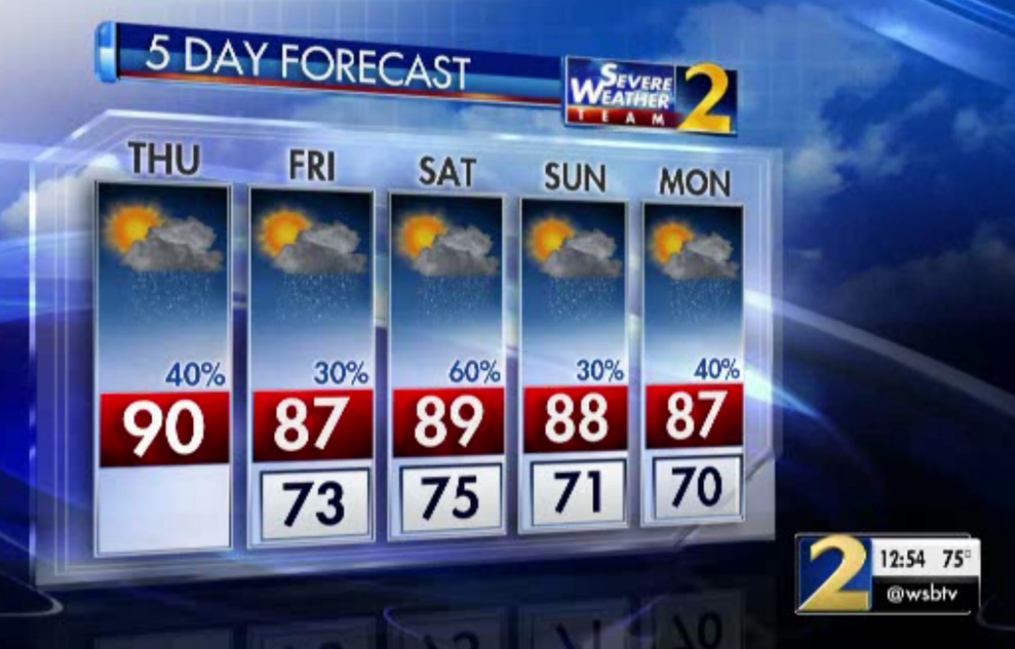
Thursday: High: 90
Thursday night: Low: 73
Friday: High: 87
» For a detailed forecast, visit The Atlanta Journal-Constitution weather page.
The evening commute should turn out to be a mostly dry one within the Perimeter, but west and east Georgia are experiencing some very slow-moving downpours, Channel 2 Action News reported.
The Downtown Connector is still a mess and hasn't gotten much better since lunchtime. The connector is littered with the fallout of crashes, causing backups and delays, according to the WSB 24-hour Traffic Center.
Heavy delays remain even after an earlier wreck on I-20 near Capitol Avenue cleared, the Traffic Center reported.
Trouble downtown; I-75/85 NB approaching I-20; CLEARED; STILL slow coming up from Langford Pkwy; #ATLTraffic; https://t.co/dp00IZtzfe
— AJC WSB Traffic (@ajcwsbtraffic) July 19, 2018
A stalled tractor-trailer on I-285 North near Martin Luther King Jr. Drive is briefly blocking all lanes and causing big delays, the Traffic Center reported.
WSB Jam Cam shows HERO hooking up to tow this big rig I-285/nb (Inner Loop) s of MLK (exit 9). All lanes blocked for now. Big delays. #TRAVELADVISORY #ATLtraffic https://t.co/2hvjWkI3bV pic.twitter.com/okTGYDPROD
— AJC WSB Traffic (@ajcwsbtraffic) July 19, 2018
More tropical moisture is on the way to end the week, which could trigger more widespread storms.
Showers and storms will be more numerous today. Heavy downpours and lightning are our main threats. In areas where rain doesn't cool us down, temperatures will be HOT with heat indices reaching the mid-90s. @GlennBurnsWSB and I will be tracking it at 4pm! pic.twitter.com/Av6zu6Mwmx
— Katie Walls (@KatieWallsWSB) July 19, 2018
While conditions are quiet now in metro Atlanta, the dew point is on the rise and storms are in the forecast, according to Channel 2 Action News.
“Dew points are already running in the low 70s, and overall the air is quite muggy,” Channel 2 meteorologist Katie Walls said.
A front south of metro Atlanta will start moving north today bringing more tropical moisture to north Georgia. This will increase our chances of rain and storms starting this afternoon and increasing the next couple of days. Updates all morning on WSB-TV pic.twitter.com/9E6XUaYEBX
— Karen Minton (@KarenMintonWSB) July 19, 2018
Most of the heavy downpours are relegated to west Georgia near Carroll County, Channel 2 reported. The storms aren’t moving anywhere fast, so ponding on roadways is a possibility.
Wednesday was able to reap the benefits of drier air with only a few isolated afternoon showers, but Thursday’s are expected to be more “typical” of this time of year, Walls said.
Slow-moving storms out there this afternoon -- and a threat of severe storms as we move into the start of the weekend. @KatieWallsWSB & @GlennBurnsWSB updating the forecast now on @wsbtv.
— Brian Monahan, WSB (@BMonahanWSB) July 19, 2018
“Today will be a transition day,” Walls said. “We’ll head back into a typical summertime pattern with scattered storms developing this afternoon and highs topping out near 90 degrees. While a few strong storms are possible this afternoon, the better opportunity for stronger storms will be tomorrow.”
Scattered showers and storms will develop in a few areas this afternoon. More will form Friday night into Saturday morning. I'm showing the hour by hour timing of storms at 5:49 on Ch2 WSB-TV pic.twitter.com/Et2UFruybn
— Karen Minton (@KarenMintonWSB) July 19, 2018
A lower 40 percent chance of rain won’t help drop the temperature much, Channel 2 meteorologist Karen Minton said. Thursday’s predicted high is 90 degrees, and it’ll remain in the upper 80s through the weekend.
“Cooler afternoon temps are expected the rest of the week as our rain chances increase,” she said.
Friday has a 30 percent chance, which increases to 60 percent Saturday before dropping back to 30 percent Sunday.
Lower rain chances today will lead to higher temperatures this afternoon. Cooler afternoon temps are expected the rest of the week as our rain chances increase. pic.twitter.com/cxO1n8CrZT
— Karen Minton (@KarenMintonWSB) July 18, 2018
A cold front now in South Georgia is expected to pull moisture north throughout the day and ramp up rain chances Saturday.
The National Weather Service has already highlighted many far North Georgia counties as risk areas for strong thunderstorms.
“The most likely time of strong to severe storms is going to end up overnight Friday into Saturday morning,” Minton said.
The next disturbance will bring a chance of strong to severe storms to NW GA on Friday night. Late evening will be the best time frame. Isolated in yellow, and scattered in the orange areas. Primary threat is damaging wind. pic.twitter.com/nBPV12Zmuw
— Karen Minton (@KarenMintonWSB) July 19, 2018
Severe storms could start to move in about 2 a.m. Saturday, and very heavy rain and damaging wind are the primary threats. Showers should be on and off for Saturday afternoon, according to the latest forecast from Channel 2.
Another round of strong to severe storms possible early Saturday while you are still sleeping. Stay weather aware and download our severe weather team2 app for warnings and alerts. https://t.co/LOP2OwGswt pic.twitter.com/zPstB0gU3h
— Karen Minton (@KarenMintonWSB) July 19, 2018
The heavy amounts of rain earlier this week has brought the amount of E. coli in the Chattahoochee River to unhealthy levels, Channel 2 reported.
No matter the weather this weekend, don’t head to the Hooch to cool off. Most likely, you’ll want to avoid all rivers and lakes Friday night and Saturday morning.
Heavy rain yesterday pushed E. coli levels to the unhealthy range again. Stay out of the 'hooch' pic.twitter.com/9i4mbo1vqs
— Karen Minton (@KarenMintonWSB) July 17, 2018
» For updated traffic information, listen to News 95.5 and AM 750 WSB and follow @ajcwsbtraffic on Twitter.
» Download The Atlanta Journal-Constitution app for weather alerts on-the-go.
About the Authors

Zachary Hansen, a Georgia native, covers economic development and commercial real estate for the AJC. He's been with the newspaper since 2018 and enjoys diving into complex stories that affect people's lives.