Atlanta is embarking on the toughest challenge to completing the Beltline: Finding a path through the northwestern segment.
Among the challenges: Crossing I-75, Peachtree Road and a massive railroad yard; placing the trail as close as possible to Piedmont Hospital; plotting a route through affluent residential neighborhoods; and spanning a large stormwater retention pond in a booming section of the Westside.
And unlike most of the planned 22-mile Beltline that would circle the city, the segment does not have an inactive railroad bed to use as a guide for its route. It’s like blazing a trail through a forest without a footpath.
Atlanta Beltline Inc., the city agency tasked with creating the paved walking and biking path, saved the northwestern segment for last because of the sheer difficulty, said Kim Wilson, vice president of design and construction. There is a dizzying combination of potential routes to consider, along with at least a half dozen priorities to address.
“We’re vetting everything to see what’s the right fit,” Wilson said.
It’s largely the reason why work has begun on every quadrant of the Beltline except the northwest. And it’s a big reason why the loop isn’t expected to be completed before 2029, about 21 years after the first portion opened in southwestern Atlanta.
So far, roughly eight miles of the Beltline loop have been paved and another four miles have dirt tracks in place. Work has not begun on a planned transit line.
The recommended route through the roughly 4.4-mile northwestern segment may be released as soon as December.
About 15 people are studying maps and real estate documents to ascertain which northwest route has the best chance to get built. Atlanta Beltline recruited the PATH Foundation to help map out potential paths, since the group has already built separate trails in some nearby areas. The special team also includes outside consultants.
Credit: Jenni Girtman
Credit: Jenni Girtman
During a public presentation on Aug. 2, Beltline staff showed slides to demonstrate the wide variety of options available. For crossing I-75, the city could build a bridge over the freeway just north of the Howell Mill Road exit, or a walkway raised on concrete pillars under the highway.
The tunnel that could be used for crossing I-75 is now a homeless camp, located at the rear of the parking lot at the Atlanta Technology Center office complex, and would be located within a few yards of a major freight rail line.
It also will be difficult for the Beltline to cross Peachtree Road, Greta deMayo, executive director of the PATH Foundation, said during the August presentation. Planners don’t want Beltline users to cross the important thoroughfare, but using the tunnel underneath the road won’t be easy either.
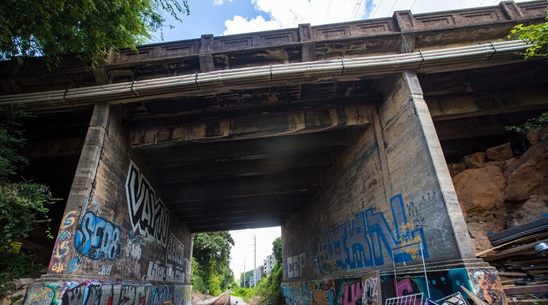
The tunnel under Peachtree Road, just south of Bennett Street, is used by CSX trains. The tunnel, built in 1914, is narrow and decrepit. A large Georgia Power substation limits space for how trail users can approach it. CSX declined to comment.
Credit: Jenni Girtman
Credit: Jenni Girtman
But the most difficult task may be figuring out how to span a segment of the Norfolk Southern Inman Yard between Huff Road and West Marietta Street, an active freight rail facility. It will likely take a major financial outlay to persuade a private railroad company to cooperate with trail planners and make right-of-way available, said Matthew Rao, chairperson of Beltline Rail Now, a nonprofit group that supports prioritizing development of mass transit along the corridor.
Norfolk Southern could ask the state or city “to pay for double tracking some of their trackage, or rebuilding one of their yards,” Rao said.
Norfolk Southern spokesman Jeff DeGraff said the railroad has not held talks with the city about the Beltline crossing Inman Yards.
Credit: Jenni Girtman
Credit: Jenni Girtman
Where planners choose to locate the northwestern trail segment may determine the route of the mass transit line planned for the Beltline. The transit element, rail or bus, does not need to be next to the trail. But it may be cheaper if it does piggyback on the right-of-way, said Rao, whose group favors rail.
The city’s examination of Beltline transit is taking place separately from the northwest trail study. Beltline planners will seek bids from engineering and design firms in early 2022 to conduct a transit feasibility study, partially funded by a $2.8 million grant from the Federal Transit Administration. Current plans call for building transit along only 15 miles of the 22-mile Beltline, with an estimated completion date of 2040.
In analyzing the walking path’s northwestern route, planners will take into consideration the estimated time to complete construction, the quality of the trail experience, neighborhood support and other criteria.
Cost will be a factor, too. Some potential routes could be deemed too expensive if property owners are unwilling to sell for a reasonable price, planners said. Many lots along the Beltline have sold for a premium.
In October 2020, the city bought a vacant 9.3-acre lot near Murphy Avenue for $5.25 million along the southern portion of the trail. Real estate prices in northwest Atlanta are more expensive, though the Beltline will likely avoid some of the priciest neighborhoods.
Officials have not determined the cost for acquiring real estate and construction of the northwestern segment. About $670 million has been spent on the Beltline since 2005.
Atlanta City Council in March approved a new tax for businesses and apartment complexes within a half-mile of the Beltline to help pay for the trail’s completion. City leaders justified the tax increase in part because of property taxes lost from the Great Recession, and in part from tax abatements granted to developers of projects along the Beltline.
The next public meeting to discuss northwest trail options is scheduled for October.
Once a recommended route is chosen, the city will hire firms to conduct more-detailed engineering studies.
If all goes well, the 22-mile circle could be complete by the end of this decade.
--Staff writer J. Scott Trubey contributed to this article.
About the Author
Keep Reading
The Latest
Featured


