WEATHER-TRAFFIC: Wrecks making evening commute difficult; Atlanta peaks in low 80s
It’s shaping up to be a slow evening commute across metro Atlanta.
Wrecks and an increase in volume are affecting the Downtown Connector and most Northside interstates, so it's a slow trek home, according to the WSB 24-hour Traffic Center.
A tractor-trailer crash has all eastbound lanes of Steve Reynolds Boulevard shut down just before I-85 in Gwinnett County, according to the Traffic Center.
Multiple lanes of Ga. 316 are blocked for a crash at Harbins Road near Dacula, the Traffic Center reported.
Delays also linger on I-85 South after a crash near Jimmy Carter Boulevard, the Traffic Center reported.
Friday morning was the first in a while that a long-sleeve shirt or light jacket was warranted with lows in the 50s across North Georgia, Channel 2 Action News meteorologist Katie Walls said. Temperatures bottomed out at 60 degrees at Hartsfield-Jackson International Airport.
Temperatures have risen, but only to the low 80s, according to Channel 2. The city has peaked at 83 degrees, which is one degree warmer than projected.
“It is feeling very fall-like,” Walls said.
Once the sun goes down, temperatures will still be comfortable. In the northern Atlanta suburbs, numbers could dip into the mid-60s before the end of high school football games, according to Channel 2.
Walls said the city will run a little warmer.
“For those of you heading out this evening, whether it’s for Friday night lights or just to enjoy a night on the town, at 7 p.m. those temperatures running in the lower 70s,” she said. “Cooling into the lower 70s by 9 p.m.”
The clear skies will continue through the overnight hours, she said. Another morning in the 50s is in the forecast Saturday.
“At this point, your Saturday morning is starting out mostly sunny, a little bit more cloud cover, but again those morning lows on the cool and comfortable side,” she said. “If you wish, you can open up those windows yet again and let nature’s air conditioning do its job.”
By the afternoon, temperatures are expected to rebound into the upper 80s. The return of 90-degree heat is just days away, Walls said.
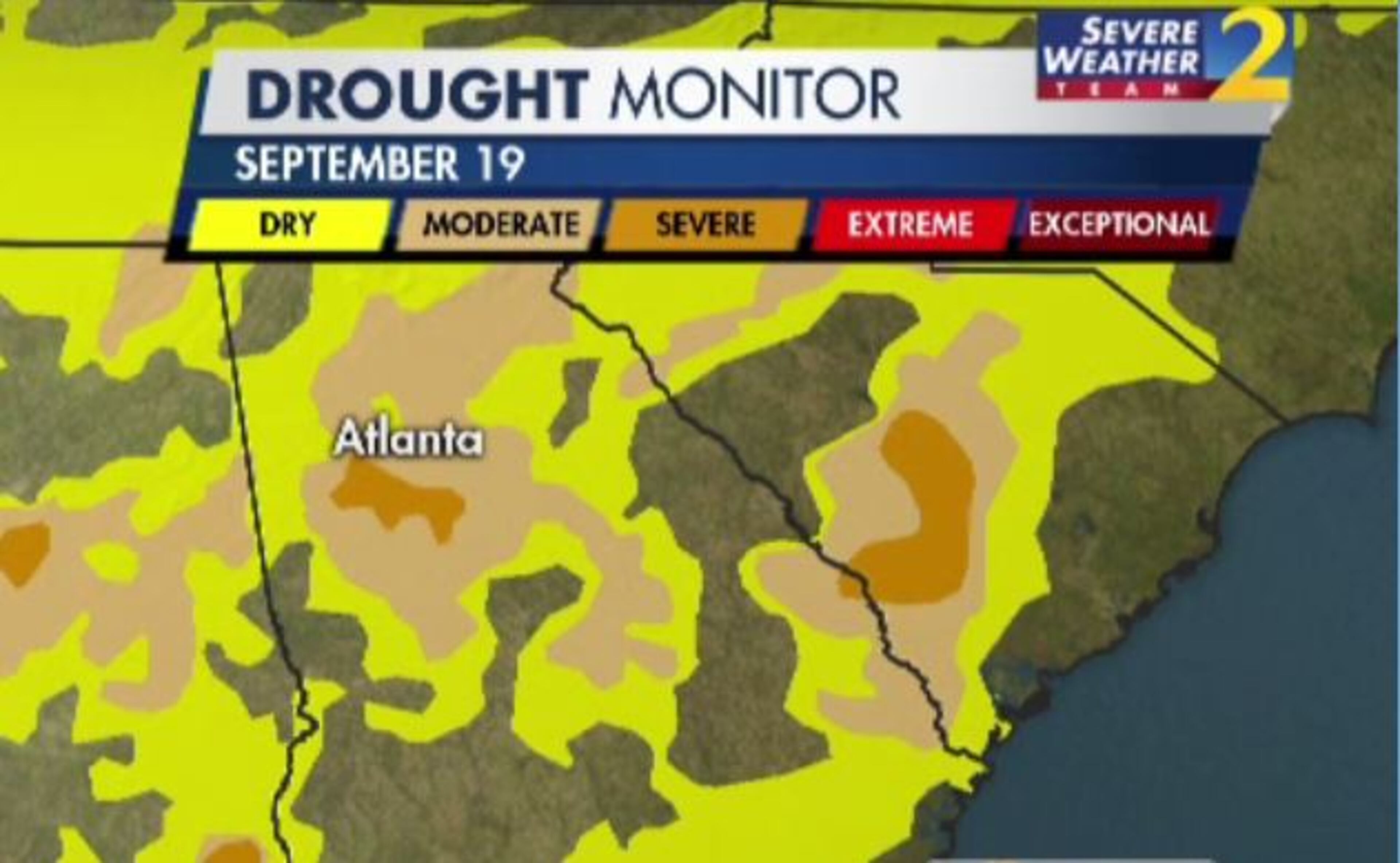
Through the start of next week, no rain is in the forecast. The drought in Georgia is getting worse, Walls said. About 40% of the state was in some form of drought last week, but as of Thursday, drought conditions are now in place for 65% of the state.
Prolonged dry conditions are a far cry from the historic flooding that left much of metro Atlanta underwater and claimed 10 lives in September 2009. Thursday was the 10-year anniversary of the floods.
Walls said it may be hard to imagine given current conditions, but flooding on an epic scale could happen again. It is not a matter of if, she said, it’s when.
“As the metro grows, the risk for flash flooding is actually going up,” she said.
Urban growth brings more concrete and fewer trees, both of which contribute to increased risk for flash flooding. Anytime rainfall amounts exceed normal levels, flooding is possible, Walls said.
“While the chances of getting 10 inches of rain in one day is 1 in 10,000, daily thunderstorms can produce up to 3 inches on any given afternoon,” she said. “We saw it last Friday night. We had some of that flash flooding, and it was because there was not enough areas for that water to flow.”
Currently, the worst drought conditions are in North Georgia. Atlanta has received only two-tenths of rainfall in September, and areas on the Southside are experiencing severe drought, according to Channel 2.
“At least cooler temperatures today will help a bit,” Walls said.

» For a detailed forecast, visit The Atlanta Journal-Constitution weather page.
» For updated traffic information, listen to News 95.5 and AM 750 WSB and follow @ajcwsbtraffic on Twitter.
» Download The Atlanta Journal-Constitution app for weather alerts on-the-go.
About the Authors


Zachary Hansen, a Georgia native, covers economic development and commercial real estate for the AJC. He's been with the newspaper since 2018 and enjoys diving into complex stories that affect people's lives.

