WEATHER-TRAFFIC UPDATE: Traffic heavy in DeKalb, Henry counties; flash flood watch issued
ATLANTA FORECAST
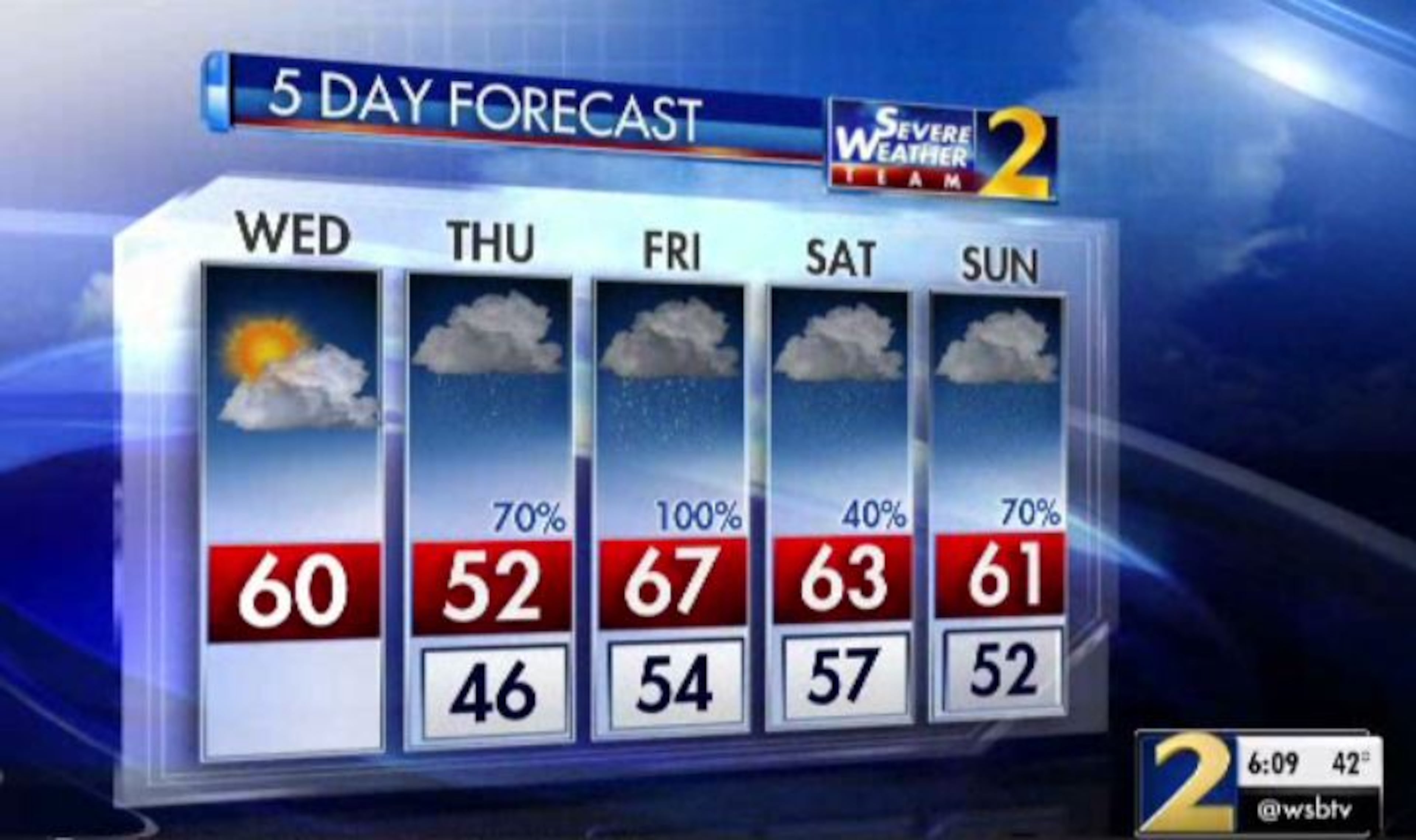
Wednesday: High: 60
Wednesday night: Low: 46
Thursday: High: 52
» For a detailed forecast, visit The Atlanta Journal-Constitution weather page.
Holiday travelers and post-Christmas shoppers continue to flood the roads Wednesday afternoon, making for some very heavy traffic conditions on I-75 South.
However, the worst traffic is in DeKalb County on I-20 after a crash blocked all westbound lanes past Flat Shoals Road, according to the WSB 24-hour Traffic Center. Two center lanes have reopened, but delays have mounted to nearly 10 miles, according to traffic cameras.
MORE: 2 lanes open after wreck blocked I-20 West in DeKalb; heavy delays linger
#REDALERT DeKalb Co: I-20/wb past Flat Shoals (exit 65); crash blocking all lanes; delays https://t.co/2hvjWkI3bV #ATLtraffic pic.twitter.com/llIsjZMosM
— AJC WSB Traffic (@ajcwsbtraffic) December 26, 2018
Backups on I-75 South start back before the I-675 merge and continue until Bill Gardner Parkway at the exit for the Tanger Outlets in Locust Grove, according to the Traffic Center. Those headed to the outlets will want to plan for extra travel time.
...and the mass exodus begins.
— AJC WSB Traffic (@ajcwsbtraffic) December 26, 2018
Henry Co: I-75/sb from Hwy 54 (exit 233) down to McDonough and I-75/nb from Hwy 16 (exit 205) up to Jodeco Rd (exit 222); heavy travel delays; use Hwy 23 or Hwy 41 as alternates https://t.co/2hvjWkI3bV #ATLtraffic pic.twitter.com/R0Ispr6f9R
To alleviate some of the congestion, the Georgia Department of Transportation did not reverse the I-75 express lanes in Henry County as scheduled Wednesday.
“For now, the lanes will remain in the southbound direction until 10:30 p.m. tonight,” GDOT said on Twitter.
Heads up! Due to the current heavy congestion conditions on I-75 southbound through Henry County, we will not reverse the Express Lanes at 11:00 AM. For now, the lanes will remain in the southbound direction until 10:30 PM tonight. pic.twitter.com/lTBRmuH7nn
— Georgia DOT (@GADeptofTrans) December 26, 2018
In the northern suburbs, the drive on I-575 is moving fine between the Outlet Shops of Atlanta in Woodstock and Town Center mall in Kennesaw, the Traffic Center reported.
Enjoy the sunshine and mild temperatures Wednesday afternoon because it could be the last sunny day of the year in North Georgia, according to Channel 2 Action News.
Overnight Wednesday, clouds are expected to thicken ahead of a series of showers and storms that could carry North Georgia through New Year’s Eve.
Starting Thursday, “settle in for what’s going to be a wet several days,” Channel 2 meteorologist Brian Monahan said.
Widespread rain moves in tomorrow afternoon-evening and continues in waves over the next week. 4-6" rainfall is expected over the next 7 days. 2-3" of that comes Thursday and Friday.
— Brad Nitz (@BradNitzWSB) December 26, 2018
I'll have the timing live on @wsbtv at 4/5/6/11 pm. pic.twitter.com/22G4qwWOIR
A flash flood watch was issued Wednesday for North Georgia. The watch, which is scheduled to go into effect at 7 p.m. Thursday and expire at 7 a.m. Saturday, means metro Atlanta and other areas could see up to 2.5 inches of rainfall, Channel 2 meteorologist Brad Nitz said. Some areas could get higher totals.
FLASH FLOOD WATCH has been issued for our area effective Thursday evening through Saturday morning.
— Brad Nitz (@BradNitzWSB) December 26, 2018
1.5-2.5 inch rainfall will be common, with some areas with higher totals.
Note, 4-6" rainfall is possible over the next 7 days so updates are likely. pic.twitter.com/J8b03z7Mat
Wednesday morning started out mostly clear with temperatures in the mid-40s. By the afternoon, sunshine should warm up metro Atlanta to 60 degrees, which is above average for this time of year, according to Channel 2. It’s currently 58 degrees.
“Tomorrow morning, a whole different ballgame,” Monahan said. “We’re going to have a lot more cloud cover around to start the day (Thursday).”
DRY & MILD: Good morning! We're set up for a dry and pleasant day today with temperatures getting close to 60 degrees. Enjoy it -- because it may be the last time many of us see the sun in 2018!
— Brian Monahan, WSB (@BMonahanWSB) December 26, 2018
I'm looking ahead to a very wet forecast -- now on Ch. 2! pic.twitter.com/Jlh0OZqeow
An east wind is expected to pick up later Wednesday, but it shouldn’t mean colder temperatures until Thursday, Monahan said. Temps aren’t expected to get out of the 50s Thursday afternoon, when light showers could start to build in, according to Channel 2.
While the Thursday morning commute is expected to be mostly dry, the evening commute should be wet, Monahan said.
“As this warm front lifts through, we’ve got rain, heavy at times, moving across North Georgia,” he said. “Could be a few strong storms ... early on Friday morning.”
More rain is expected for the drive in to work on Friday.
Rain kicks off with a wedge on Thursday... even wetter on Friday with a chance of storms.
— Brian Monahan, WSB (@BMonahanWSB) December 26, 2018
One system moves out... another one moves in for the second half of the weekend.
We have the potential to challenge 1948 for wettest year on record in #ATL! @wsbtv
“Wet is going to be the story over the next couple of days,” Monahan said. “It’s not going to rain all the time, but more often than not we're tracking showers, and another batch of them coming in Saturday into Sunday.”
The rain should stick around through New Year’s celebrations, he said. As it stands, 2018 is the eighth wettest year on record in Atlanta. The record was set at about 72 inches in 1948, according to Channel 2.
3-5”+ rainfall expected through the end of the year, beginning Thursday.
— Brad Nitz (@BradNitzWSB) December 26, 2018
We’re going to climb up this list. I’m tracking the rain live on @wsbradio and @wsbtv today. pic.twitter.com/FQgTkwX0oc
“We’re about 6 inches away from the record,” Monahan said. “It’s possible we’ll get close to that over the next few days, in terms of how much rain we could see across North Georgia.”
» For updated traffic information, listen to News 95.5 and AM 750 WSB and follow @ajcwsbtraffic on Twitter.
» Download The Atlanta Journal-Constitution app for weather alerts on-the-go.
About the Authors


Zachary Hansen, a Georgia native, covers economic development and commercial real estate for the AJC. He's been with the newspaper since 2018 and enjoys diving into complex stories that affect people's lives.

