Savannah’s sea level is rising faster than other coastal cities. How is that possible?

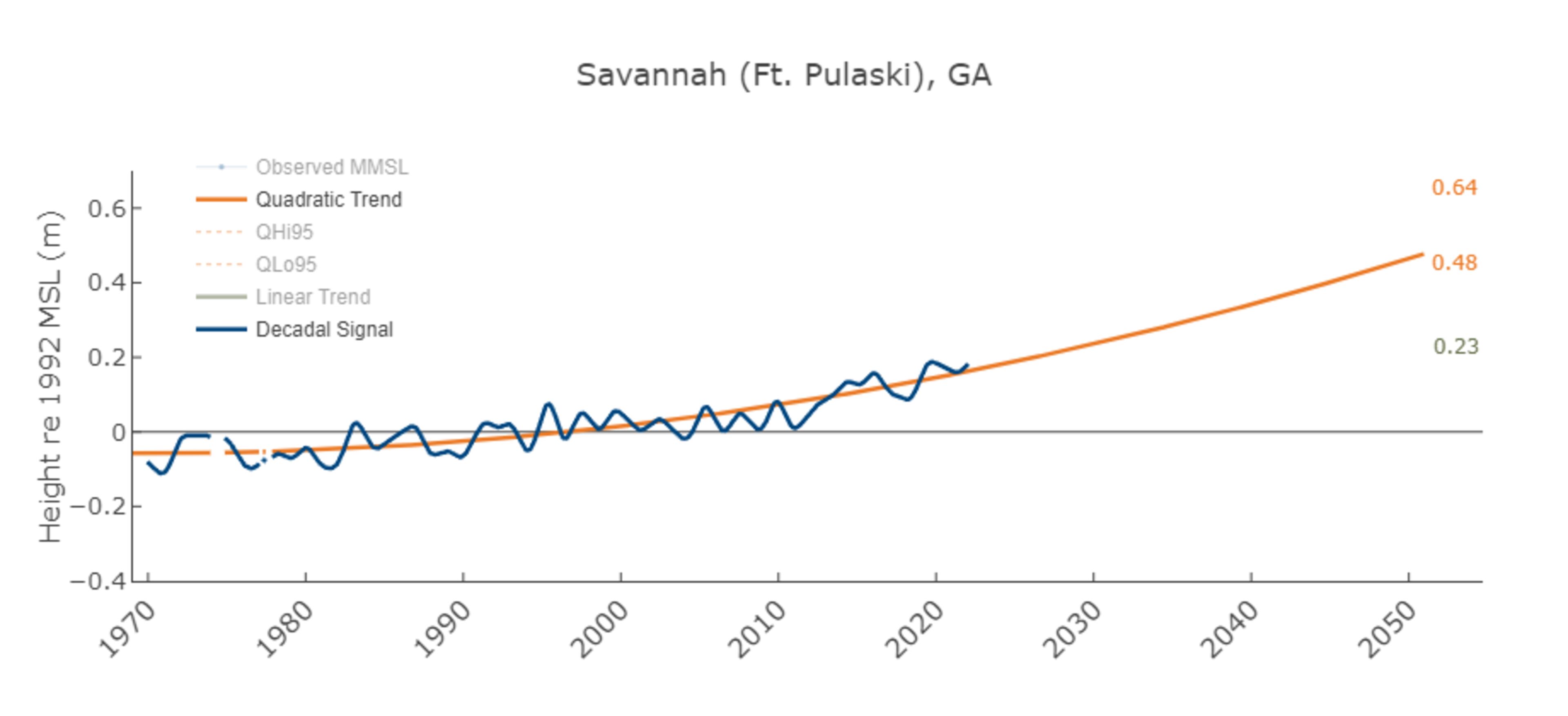
The Virginia Institute of Marine Science at William & Mary recently released its annual report card of sea-level rise in 32 coastal cities throughout the United States. Savannah holds the unfortunate position of third place, reaching about 1.5 feet of sea-level rise by 2050, but experiencing much of that rise earlier than most other studied cities.
The VIMS analysis doesn't just tell Savannahians what they already know, that the sea level is rising and causing more flooding. It also unpacks how quickly the city will see that rise in the upcoming decades with nuanced analysis for local planners.

What is sea level rise and where do we see it in coastal Georgia?
Sea-level rise is a natural phenomenon that has been exacerbated by climate change, which is in turn created by human actions like emitting greenhouse gases from coal-fired energy plants. Those greenhouse gases trap heat in the atmosphere. And that heat can be linked to the ocean levels rising.
Sea-level rise can largely be attributed to two sources: ice melting and temperatures rising.
Global warming melts ice, which displaces water like dropping ice cubes into a glass causing it to spill over. But higher temperatures also cause something called thermal expansion − water molecules expand as they are heated. So water is taking up more space.
"A common misconception we see out there is that sea-level rise is only going to impact that spot where the ocean meets the shore or our beaches," said Mark Risse, director of the University of Georgia Marine Extension and Sea Grant. "When the sea level rises ... we have high tides that go way up the Savannah River. The tidally influenced areas of Georgia can go 15, 20 miles inland fairly easily."
Aside from the beachfront or flooding Highway 80 to Tybee, one way coastal residents see sea-level rise is in stormwater drainage, the system that carries rainwater from neighborhoods and streets back into the rivers, streams and waterways via drains and pipes. These systems mostly use gravity to get rainwater to flow from streets into the body of water that is its final destination.
But when the high tide gets too high, the rivers and streams that rise and lower with the tide start intruding into those stormwater drainage pipes. The pipes can't drain as much rainwater, creating worse flooding at street level.
That's why sometimes when it rains the flooding doesn't seem so bad, but on other days when the rain seems more light, the flooding is worse because the tide was higher.
A rising tide lifts all boats? Research says not equally along coast
While there are general trends of sea-level rise worldwide, the water is getting higher faster in some places.
Molly Mitchell, a research assistant professor at VIMS, said that the report cards look at relative sea-level rise − what that rise feels like to someone standing at the shoreline − and adds nuance to explain why the sea level is rising quicker in some coastal cities in comparison to others.
For Savannah, the tide gauge at Fort Pulaski gives scientists long-term data on the sea level in coastal Georgia. Using that longitudinal data, the researchers can predict what the future may hold and conclude that not only is the sea level rising in coastal Georgia, but the rate of how fast it is rising is quicker than in most other coastal cities they studied.
The researchers' projections for other locations have those cities' sea-level rise catching up with Georgia. That can be explained by the many other factors that go into those calculations, such as subsidence, where land is sinking. This isn't an issue in Georgia in comparison to the Gulf Coast or Louisiana, where groundwater and fossil fuel extraction have caused the land to sink.
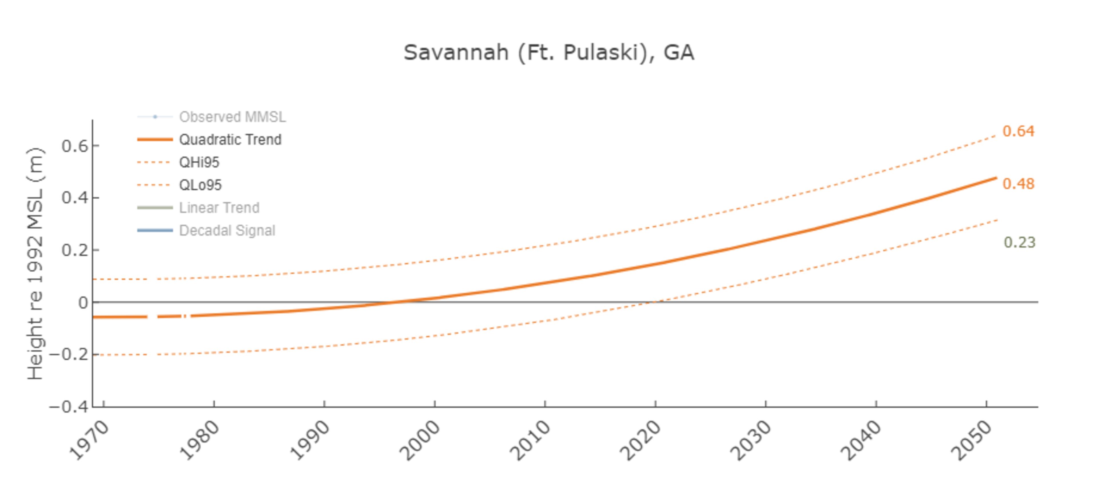
While a lot of conversations around sea-level rise look at the one number − the estimated number of feet the water will be higher − Mitchell said VIMS also calculates estimated variations in sea level. Each day the tide goes in and out, and some months hurricanes and storms come through lifting the water level. Planners need to accommodate for the unusually high or unexpectedly low sea level they might see.
Read more about the study at VIMS' website: www.vims.edu/research/products/slrc.
Mitigation, restoration, destination
In Georgia, the rapid rise means that planners have less time compared to other areas to mitigate impacts.
Risse said there are a lot of ways communities are battening down the hatches for sea-level rise. Some are using green infrastructure, like rain-absorbing gardens, while also building infrastructure up like putting houses on stilts.
Risse said one alternative considered in other parts of the country that hasn't caught on in Georgia is retreat, the idea that communities should build further back from the water. After Hurricane Sandy, Risse some parts of New Jersey communities built homes farther back to build dune systems that naturally prevent flooding.
Marisa is an environmental journalist. She can be reached at 912-328-4411 or at mmecke@gannett.com.
This article originally appeared on Savannah Morning News: Savannah’s sea level is rising faster than other coastal cities. How is that possible?
MEET OUR PARTNER
Today’s story comes from our partner, Savannah Morning News. Savannah Morning News provides daily news coverage on Coastal Georgia. Visit them at savannahnow.com or on Twitter @SavannahNow.
If you have any feedback or questions about our partnerships, you can contact Senior Manager of Partnerships Nicole Williams via email at nicole.williams@ajc.com.