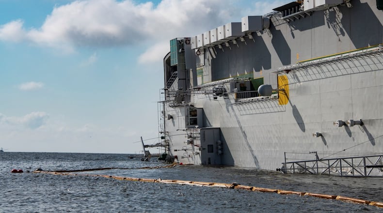
Officials working to remove the capsized cargo ship from St. Simons Sound on the Georgia coast have tried to contain fuel from the vessel, but significant amounts of pollutants that continue to flow from the ship into surrounding waterways have put environmental advocates and local boat captains on high alert.
This week, divers have worked to locate and patch a tank on the vessel that was leaking pollutants. The oil had traveled from the boat to within 2.5 miles of the shore, and the leak had not been completely stopped, said a response team spokesperson on Tuesday.
The news comes almost a month after the Golden Ray, a 656-foot vessel, capsized Sept. 8 carrying 24 crew members and 4,200 vehicles. After the vessel rolled onto its left side, a fire broke out. All crew members were eventually rescued, including four who were trapped in the boat until the following day. The Brunswick port reopened to commercial ships on a case-by-case basis, four days after the ship overturned, but officials say moving the boat could take months.
>> PREVIOUS COVERAGE | Brunswick port reopens days after ship capsizes
Locals who have seen black globs of oil washing up on the marshes and beaches in the area have said the environmental impacts are growing. “It is one thing for it to be way back in the marsh where no one can see it. It is another when it is washing up on the beach,” said Fletcher Sams of Altamaha Riverkeeper. On the riverkeeper website, Sams posted images of a mother trying to remove an oily black substance from her child’s feet after running on the beach. “I understand they are putting resources into this and they have increased (those resources) significantly, but it is still not adequate. The shoreline is being impacted.”
Response teams’ efforts have been two-pronged: trying to contain spills in the water and working on a plan to remove the ship. Skimmers and absorbent materials have been used to soak up oil in the water, while booms have been placed around sensitive areas to protect them.
Crews had already begun to remove the 300,000 gallons of fuel from 24 tanks on the vessel. By late Tuesday, more than 106,000 gallons had been removed. It is the first step in a complex salvage operation with no end date in sight.
Once the fuel has been removed, crews will check to see if the thousands of cars on board have shifted. The cars will likely be removed one by one before righting the ship, as has been done in similar maritime disasters, said Ben Morgan, owner of Morgan Marine Salvage. Some salvage team members have been sent to Chile to study the Golden Ray’s sister ship, said Chris Graph of Gallagher Marine Systems, which represents the ship owner.
The focus now remains on minimizing the impact to the environment, but persistent discharges from the vessel and strong tides, which sweep pollutants out into the water, have challenged those efforts.
Scott Owens, owner and head guide of Southeastern Angling, said the problem is more serious than previously determined. When he pulled his boats from the water on Tuesday, they were coated with a substance that seemed to be at least 10 to 15 inches below the surface of the water.
He first thought the silver dollar-sized black blobs were burnt pine tree bark, he said, but when he reached down to touch it, it smeared everywhere.
“The people who aren’t on the water aren’t seeing it. The entire marsh is full of this stuff because the tides are so high,” Owens said. “This isn’t a couple of drops, it is a large area. To have it all over the boats makes me realize how much is out there.”
Owens, who usually runs about 700 chartered fishing trips per year, has already had five cancellations since the ship capsized, and he said the phone has stopped ringing. When he does have customers, he is burning up 30 gallons of fuel to take them to areas beyond the Sound where they feel comfortable fishing.
“We make our living on this, and this stuff will sit at the bottom where people won’t be able to see it, but it will kill the oysters, crabs and shrimps. This can’t be something people have forgotten and turn their heads at,” he said.
Samantha Joye, an oceanographer, microbiologist and geochemist at the University of Georgia, said it is important to know exactly what is leaking into the environment.
"... this stuff will sit at the bottom where people won't be able to see it, but it will kill the oysters, crabs and shrimps." - Scott Owens, owner and head guide of Southeastern Angling
“This remains very much a developing situation, but it is critical to assess and document areas of oil exposure now — and into the foreseeable future — so that potential impacts can be properly assessed,” Joye said. “We need to sample waters, marshes and beaches comprehensively to make sure we know where this discharged material is ending up.”
Response team representatives have said they are monitoring air and water quality as well as working with groups like the Altamaha Riverkeeper to track and evaluate oil sightings.
“We did have some oil released into the environment,” said Graph of Gallagher Marine Systems. “We have identified shoreline impacts near Quarantine Island, Lanier Island, Bird Island and the confluence of Back, Mackay and Frederica rivers with various degrees of oil and sheen in the marshes.”
Sams said the riverkeeper has been providing maps of oiled areas to the Coast Guard on a daily basis to help them get crews where they need to be. He has tracked evidence of oil within a 5-mile radius around the incident site. “We can anticipate a lot more fuel releases. If they cannot contain it in the boat or prevent it from getting out of the boat, they need to increase their response to protect our shorelines,” he said.
About the Author
The Latest
Featured


