Hurricane watchers eye 2 tropical waves moving west in Atlantic
A new tropical wave emerged Thursday morning with 60% odds of becoming the next tropical depression or storm by early next week. Meanwhile, the National Hurricane Center is watching a second tropical wave in the mid-Atlantic.
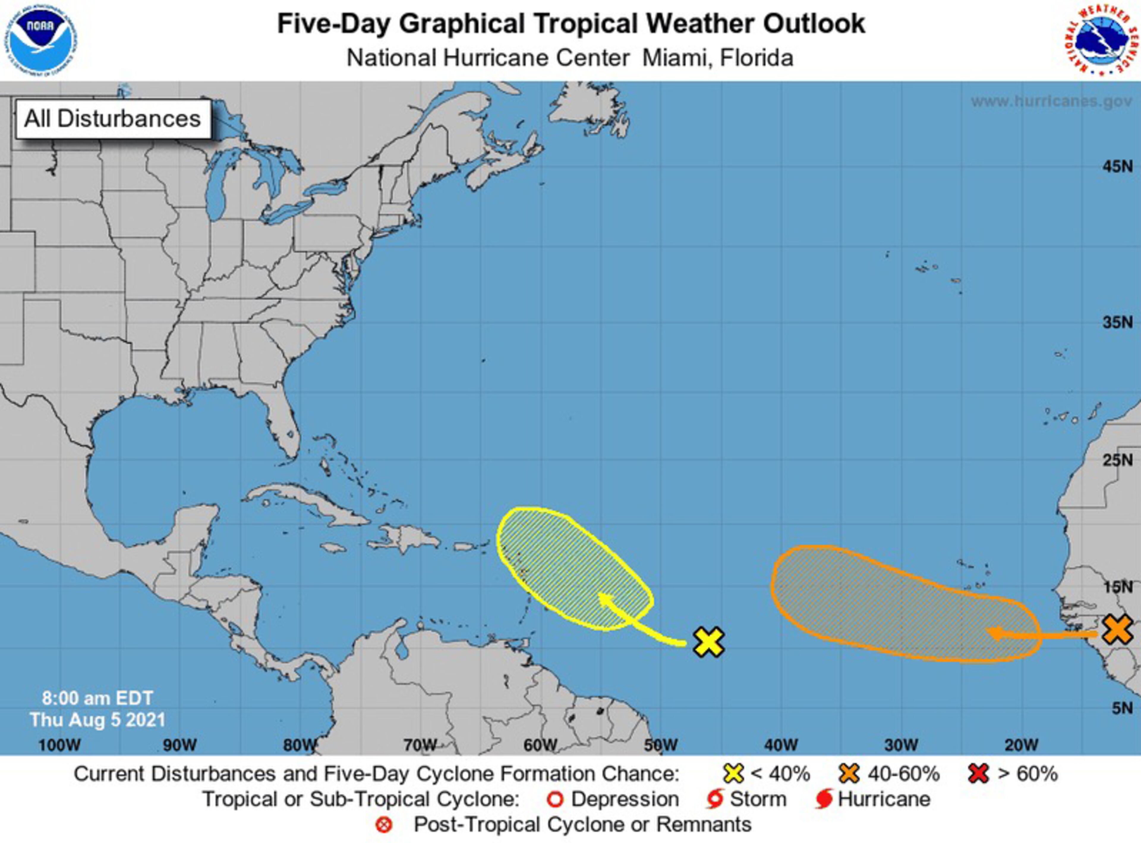
First, a tropical wave over the Guinea Highlands in Africa is producing thunderstorms Thursday morning, the NHC said in its 8 a.m. update. Hurricane specialists are expecting the wave to push off the continent later Thursday.
Atlantic conditions are somewhat ripe for development, the NHC said. That being the case, the wave has a 60% of becoming the next tropical depression over the eastern Atlantic next week and a 20% chance of doing so over the weekend.
Next, another tropical wave in the mid-Atlantic is stirring up some trouble and producing a broad area of disorganized showers and thunderstorms. Conditions east of the Lesser Antilles are expected to be marginally agreeable for development by early next week.
Models give the wave a 20% chance of becoming a tropical depression or storm in the next five days.
If either system develops, the first one to do so will be the sixth named storm of the season and don the moniker of Fred. If they both develop, the slower will be named Grace.
The areas of interest are about two weeks shy of the “peak of hurricane season,” or the period where meteorologists observe the most tropical storm and hurricane activity in the Atlantic. Conditions of warm water and low vertical wind shear in the upper atmosphere become ideal for storm production between mid-August and mid-October.
The National Oceanic and Atmospheric Administration expect the remainder of the 2021 season to be a bumpy one, according to its midseason forecast. A typical season has 13 named storms and seven named hurricanes. On Wednesday, the NOAA updated its forecast predicting 15-21 named storms with sustained winds of 39 mph or greater, seven to 10 hurricanes, and three to five major hurricanes, or storms of Category 3 winds and higher.
The NOAA predicted 13 to 20 named storms in May, with six to 10 becoming hurricanes and three to five becoming major hurricanes.
Last year, the NOAA made a similar forecast at midseason. By Nov. 30, the end of hurricane season, meteorologists cataloged 30 named storms — the most recorded in a single year.
After a record start, followed by a near-silent July, the Atlantic hurricane season looks like it will be busier than meteorologists predicted a few months ago.
NOAA on Wednesday updated its outlook for the 2021 Atlantic season, slightly increasing the number of named storms and hurricanes expected in what is predicted to be a busy — but not record-breaking — year.
The agency is now forecasting 15 to 21 named storms instead of the 13 to 20 it predicted in May. Meteorologists also said the number of expected hurricanes is seven to 10, instead of six to 10.
The chance for an above average hurricane season increased from 60% to 65%, with a 15% chance that forecasters will run past the list of 21 storm names. Last year saw a record 30 named storms and forecasters had to use Greek letters by the end of the season.
A reduction in high level cross winds, normal to slightly warmer sea temperatures, increased rains in Africa where seeds of stronger storms start, a possible cooling of the central Pacific and a general period of high storm activity since 1995 are reasons for a busy season, said lead forecaster Matthew Rosencrans.
Colorado State University, which pioneered hurricane seasonal forecasts, last month also increased the number of storms expected in its forecast.
Information provided by The Associated Press was used to supplement this report.