TUESDAY’S WEATHER-TRAFFIC: Rain to shut down before sunny afternoon
The tap is being turned off Tuesday as North Georgia sets aside the rain for a few days.
After a few morning showers clear, sunshine and warm weather are in the forecast for the afternoon, according to Channel 2 Action News meteorologist Brian Monahan. The rain is expected to start winding down by midmorning.
“It’s going to be a big change later today from the fog and low cloud cover, the rain we've seen to sunshine,” Monahan said. “Some fog and wet pavement out there this morning, but I promise you it’s going to get better.”
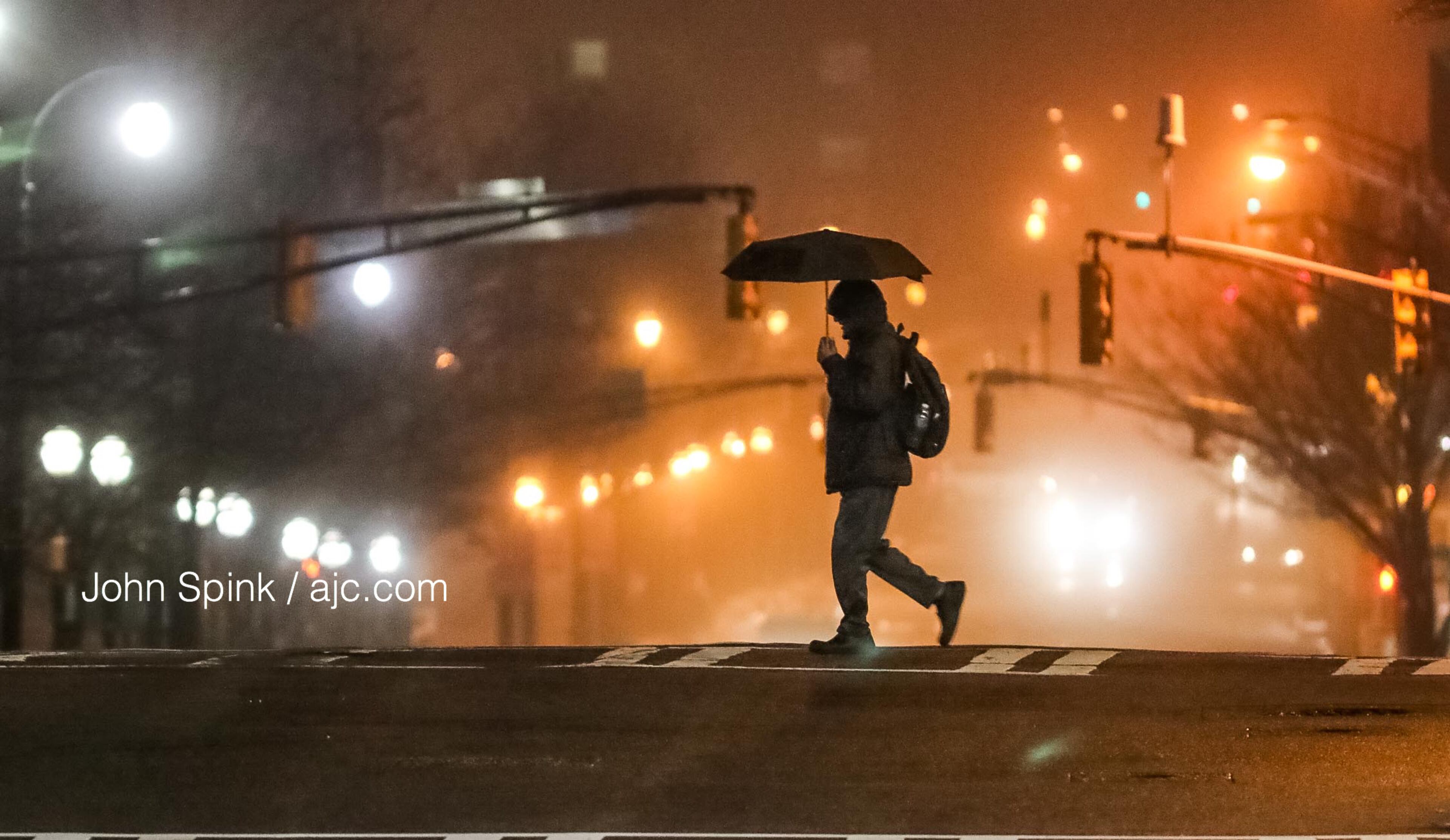
Until then, thick fog is making for a challenging morning drive. Visibility is reduced across North Georgia, but especially in the northwest corner of the state.
“Beams on low, and increase your following distance between you and the car in front of you as that fog sticks around,” Monahan said.
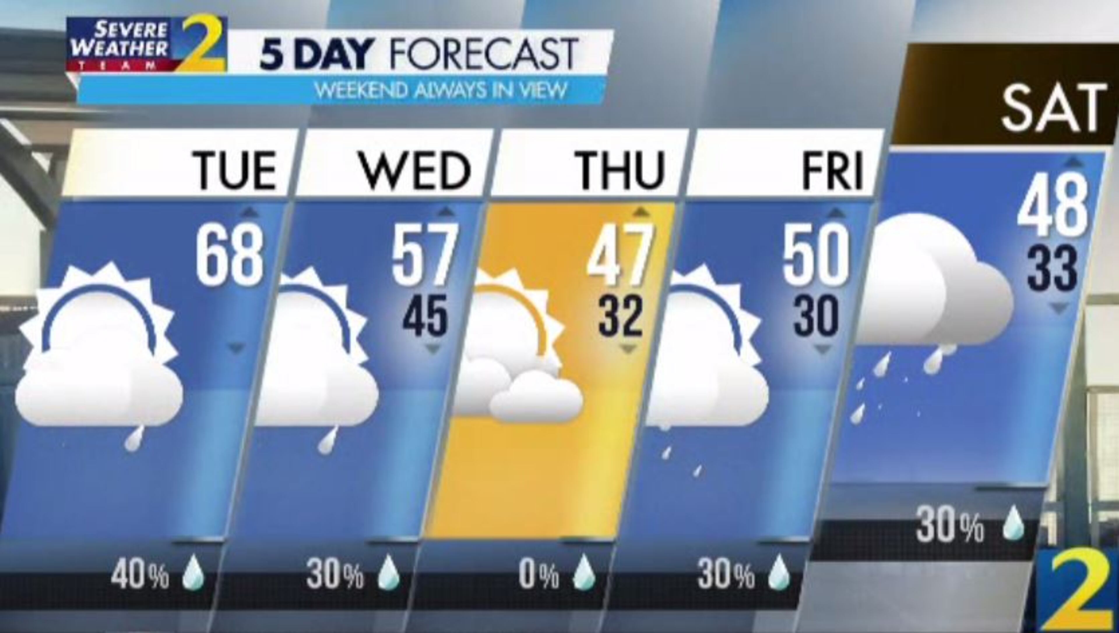
He said sunshine should start peaking through around 10 a.m., and by lunchtime, the rain is gone. There are still some chances for light showers and even some snow through the week, but Monahan said he does not expect any more heavy rain for the rest of the month.
Monday’s rain brought the rainfall total to 10.55 inches for the month of February. Since Jan. 1, Atlanta has recorded 18.56 inches of rainfall, according to Channel 2.
“Out of almost 150 Februarys on record in Atlanta, this is the second-wettest one on record,” Monahan said.
With rain for the most part shutting off after Tuesday, he said the record of 12.77 inches set in 1961 should be safe.
Atlanta is headed for a projected high of 67 degrees Tuesday once the clouds clear. Some spots could break into the 70s, according to Channel 2.
The clouds won’t be gone for good, however. Monahan said to expect to see the sky fill in overnight.
“No rain tonight, but a cold front coming through will bring us some clouds,” he said. “Colder temperatures by tomorrow, we're in the 40s, and then the opportunity by Wednesday night ... for snow showers up in the North Georgia mountains.”
Metro Atlanta could wake up to freezing temperatures Thursday on the other side of the front, according to Channel 2. Another chance for snow is coming Friday night and Saturday morning, which could also see lows in the 30s.
Volume is building and “the action is starting to pick up on the interstates” as the Tuesday morning drive gets underway, WSB traffic reporter Mark Arum said.
A crash on the Downtown Connector was blocking all northbound lanes at 6 a.m., according to the WSB 24-hour Traffic Center. That crash should clear quickly, but Arum said it is expected to do a number to the trip time.
The wreck into a wall is blocking the lanes past the Varsity at 10th Street and contributing to big delays leaving Midtown, the Traffic Center reported.
In Gwinnett County, another crash on Ga. 316 at the I-85 South ramp has the potential to significantly slow the ride out of Lawrenceville. The Peach Pass lane is blocked, according to the Traffic Center.
» For a detailed forecast, visit The Atlanta Journal-Constitution weather page.
» For updated traffic information, listen to News 95.5 and AM 750 WSB and follow @ajcwsbtraffic on Twitter.
» Download The Atlanta Journal-Constitution app for weather alerts on-the-go.
About the Author