WEDNESDAY’S WEATHER-TRAFFIC: North Georgia to feel Sally’s impact
Wednesday — as well as the remainder of the workweek — will be a total washout as slow-moving Hurricane Sally brings downpours to North Georgia.
The center of Sally made landfall near Gulf Shores, Alabama, around 5:45 a.m. as a Category 2 hurricane with 105 mph winds and heavy rain, according to the National Hurricane Center.
“Here at home, we’re going to see our rain chances start to go up today," Channel 2 Action News meteorologist Brian Monahan said. "Right now, we’ve got just isolated showers around. But we’re really going to start to feel the impacts from Sally later this afternoon, into this evening and certainly into tomorrow as that rain ― heavy at times — comes down across North Georgia. By the evening commute, we’re going to have some heavy rain.”
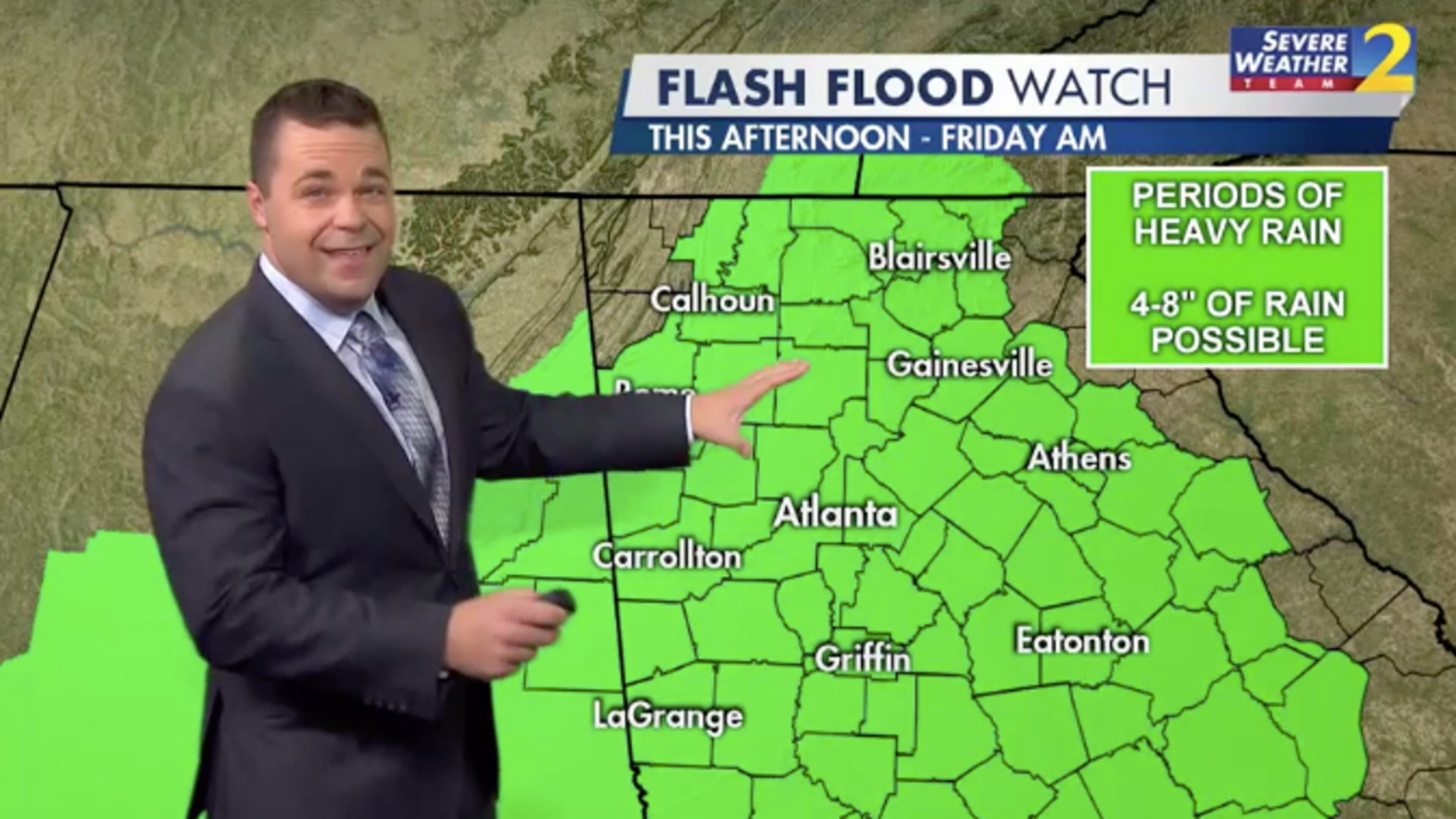
The National Weather Service has already issued a flash flood watch for all of North Georgia. That watch goes into effect at 2 p.m. and may not expire until Friday morning, according to the Weather Service.
“Periods of heavy rainfall are expected across the area with the outer rainbands of Hurricane Sally as it tracks inland today, then weakens and tracks over Georgia Thursday into early Friday,” the Weather Service said in an advisory Wednesday morning. “At this time, rainfall amounts of 3 to 6 inches are expected, with locally higher amounts possible. The highest amounts are centered along a line from Columbus, to Griffin, to Athens, where rainfall amounts could total 5 to 7 inches.”
For the moment, areas south of I-20 are receiving some sprinkles, and other parts of the state are relatively dry. At 68 degrees, temperatures in Atlanta are already near the day’s high of 70.

That changes later as Georgia starts to feel the impact of Sally, which is currently dumping punishing rain in Florida and Alabama.
“There is no way to overstate how much rain is falling across the Florida Panhandle (and the) southeast Alabama coast,” Monahan said.
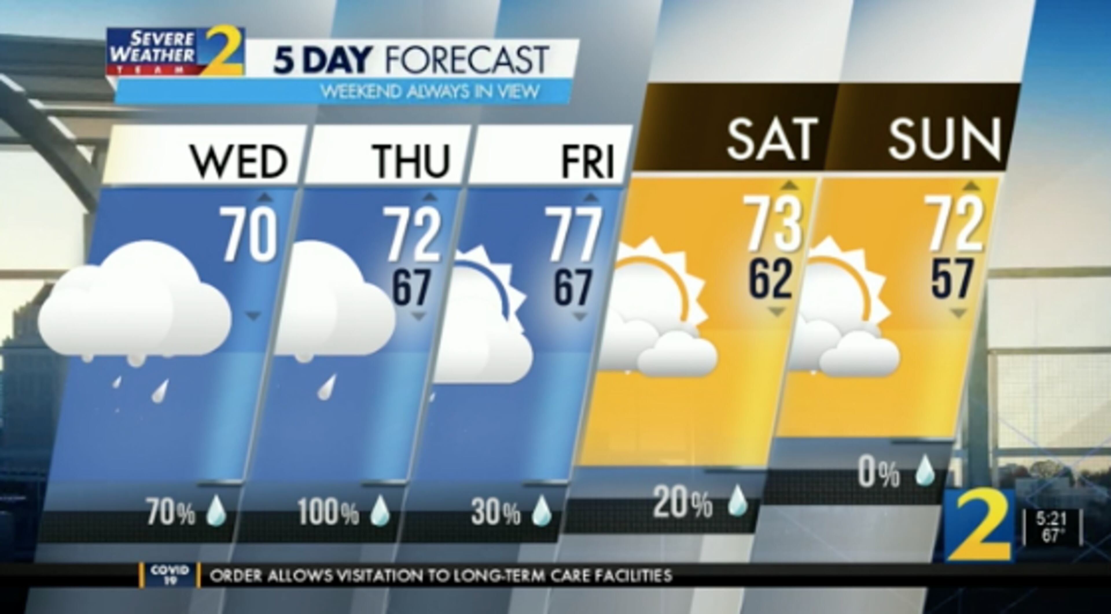
Local rain chances are 70% Wednesday and 100% Thursday, according to the latest forecast. Between now and the weekend, Monahan anticipates areas between the North Georgia mountains and the Southside could receive at least 4 inches of rain.
The lingering question is when will North Georgia see the sun again.
Monahan’s answer: Saturday. By the weekend, rain chances drop considerably. On Sunday, Monahan predicts there will be no precipitation.
While the evening commute will be a wet one Wednesday, the morning drive is off to a mostly dry start. However, there is one trouble spot on a metro Atlanta interstate, according to the WSB 24-hour Traffic Center.
In DeKalb County, all but one left lane of I-285 East is shut down at Bouldercrest Road due to a crash, the Traffic Center reported. Drivers in the area should use I-75 or Moreland Avenue as alternate routes.
» For a detailed forecast, visit The Atlanta Journal-Constitution weather page.
» For updated traffic information, listen to News 95.5 and AM 750 WSB and follow @ajcwsbtraffic on Twitter.
» Download The Atlanta Journal-Constitution app for weather alerts on-the-go.