WEATHER-TRAFFIC: I-20 blocked in west Georgia as Atlanta temps top predicted high
While several states to our west are getting soaked, North Georgia is staying bone dry, hot and humid Monday afternoon.
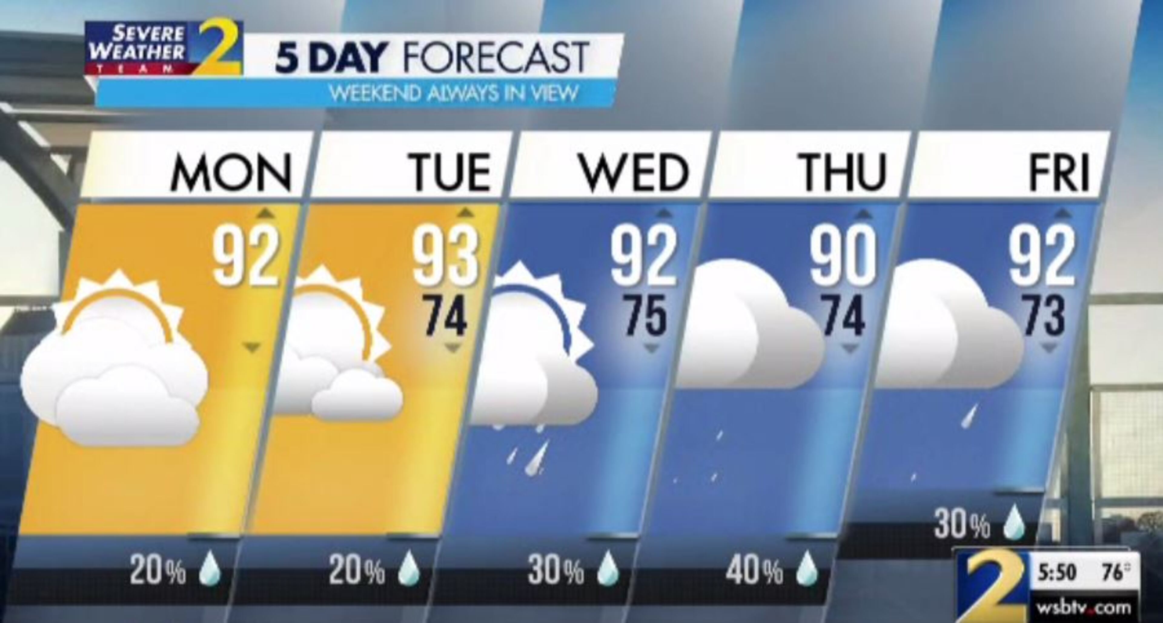
With a skimp rain chance of 20%, the weather isn’t expected to affect traffic, according to Channel 2 Action News. However, wrecks definitely have.
The worst delays are outside of metro Atlanta in Carroll County, where all I-20 West lanes are blocked near Ga. 113 by a crash, the WSB 24-hour Traffic Center reported.
The interstate also has its problems closer to the city, with a left lane blocked by a wreck before Wesley Chapel Road in DeKalb County, the Traffic Center reported.
Monday and Tuesday will be the driest days of the work week with below-average rain chances for mid-July, according to Channel 2.
What is left of Tropical Depression Barry is moving up along the Mississippi River and dumping inches more rain across an already water-logged region. North Georgia is not expected to see much impacts from the storm aside from some cloud cover, Channel 2 meteorologist Brian Monahan said.
“Nice and dry for us, even though Barry is spinning only a couple hundred miles off to our west, at least some of the rain with it,” he said. “It is going to stay pretty dry today, and it is going to be hot today across Georgia.”
It has been hot, with Atlanta hitting 93 degrees, which is a degree warmer than predicted. With the high humidity, it feels like it is in the mid-90s outside in the city, according to Channel 2. Some areas out east, where there has been the least cloud cover, have hit the mid-90s.
“There will be spots out through Athens, out through Eatonton with a really good shot to get to 95, 96 degrees today,” Monahan said. “That’s before you factor in the humidity that will make it feel like triple-digit heat.”
Any showers from Barry will stay to the west through the overnight hours Monday, and Tuesday looks to be another dry and warm start, Monahan said. He expects temperatures to reach the 80s by 9 a.m. Tuesday.
“Overall, the rain chance is very isolated for you on Tuesday,” he said. “It won’t be until Wednesday and Thursday that you notice a jump in the chance of rain.”
Rain chances increase to 30 percent on Wednesday and 40 percent on Thursday, according to the latest forecast. Showers and storms remain in the forecast through the weekend.
“Thursday, there's a front coming through that will, in part, have some of the remnants of Barry with it,” Monahan said. “That’s the highest chance of rain during the work week in the forecast, up at 40 percent. Then by Saturday and Sunday, scattered storms but also a lot of sunshine.”
The weekend will be a hot one with high temperatures in the lower 90s, he said.
» For a detailed forecast, visit The Atlanta Journal-Constitution weather page.
» For updated traffic information, listen to News 95.5 and AM 750 WSB and follow @ajcwsbtraffic on Twitter.
» Download The Atlanta Journal-Constitution app for weather alerts on-the-go.