WEATHER-TRAFFIC: Wind advisory in effect through the evening
By early May standards, North Georgia is looking at a cooler stretch of weather over the next few days.
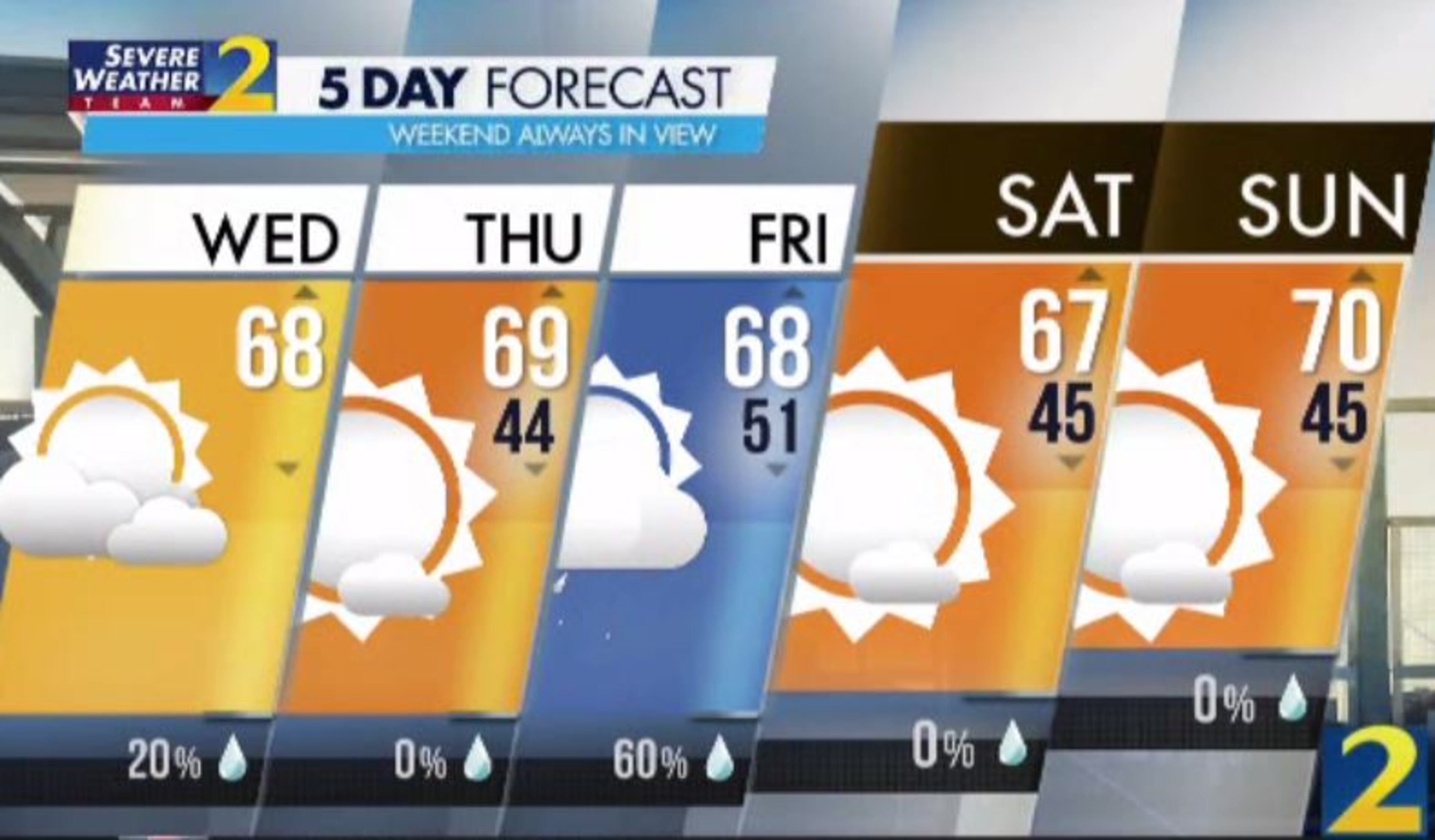
The region had been enjoying highs in the 80s to begin the month, but temperatures are dropping Wednesday on the other side of a cold front. Most of North Georgia will stay in the 60s this afternoon, according to Channel 2 Action News meteorologist Brian Monahan.
“Now, is that cold? No, not in the afternoon, but certainly cooler than we've been,” he said. “We've been used to temperatures in the 80s, so certainly a big change in the temperatures straight through Thursday, through Friday and into your weekend, too.”
Monahan said the jet stream is dipping further south, sending temperatures about 10 degrees below average. It will not be a quick shot of cooler air from which North Georgia will recover quickly, he said.
By Thursday, metro Atlanta will be waking up to temperatures in the 40s, according to Channel 2.
“This afternoon, a second cold front is coming through,” Monahan said. “This front is going to level off our temperatures in the 60s today, and along it, it’s also going to bring the chance for a few isolated showers.”
There is a slight chance for some rain in the northeast Georgia mountains by 1 p.m., and Monahan said a few of those showers could survive as they move into metro Atlanta mid- to late afternoon.
According to Channel 2, the rain chance Wednesday is only 20%.
“For the most part, we'll stay pretty dry and partly cloudy,” Monahan said.
The cold front is also bringing a moderate breeze. Most of North Georgia is under a wind advisory through 9 p.m., according to the National Weather Service.
Northwest winds of 15 to 25 mph with gusts up to 35 mph are expected, the Weather Service said in the advisory. Unsecured objects could be blown around, tree limbs could be blown down and power outages are possible.
The next weather system arrives Thursday, Monahan said. Clouds will start to thicken Thursday night ahead of expected showers Friday morning. The rain chance increases to 60% by the afternoon, according to the latest forecast.
Aside from Friday’s elevated chance of rain, Monahan said the weather will not see much variety over the next five days. High temperatures will remain in the upper 60s through the start of the weekend, he said.
“The weekend actually looks pretty; it’s just going to be on the cooler side,” he said. The forecast predicts highs of 67 degrees Saturday and 70 degrees Sunday.
There are no major delays on the metro Atlanta interstate system at midday, according to the WSB 24-hour Traffic Center.
Construction projects on surface streets could create some slow zones, however. In Gwinnett County, roadwork was blocking one lane in each direction on Sugarloaf Parkway at Satellite Boulevard, the Traffic Center reported.
And in Cherokee County, one lane is blocked in each direction on Ga. 140 at Lower Burris Road while construction crews are on site.
» For a detailed forecast, visit The Atlanta Journal-Constitution weather page.
» For updated traffic information, listen to News 95.5 and AM 750 WSB and follow @ajcwsbtraffic on Twitter.
» Download The Atlanta Journal-Constitution app for weather alerts on-the-go.
About the Author


