WEATHER-TRAFFIC UPDATE: Downtown traffic clogged as Atlanta begins cooldown
ATLANTA FORECAST
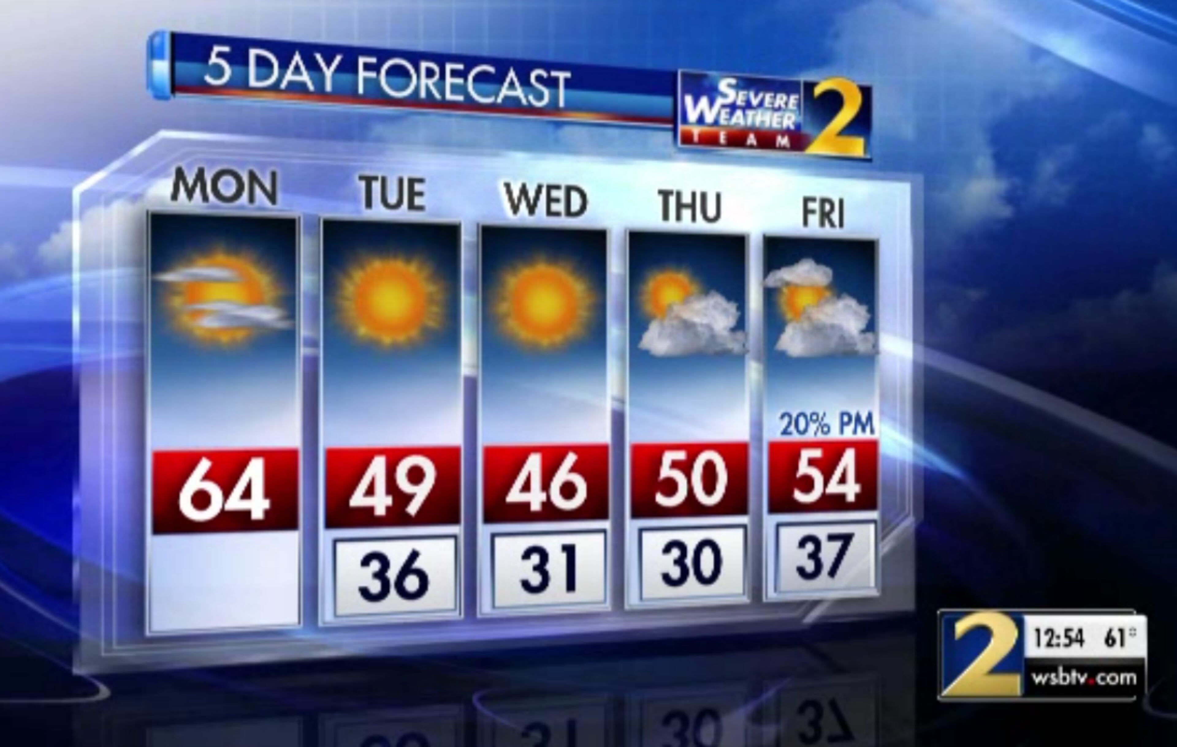
Monday: High: 64
Monday night: Low: 36
Tuesday: High: 49
» For a detailed forecast, visit The Atlanta Journal-Constitution weather page.
After reaching the mid-60s Monday afternoon, Atlanta is beginning its expected cooldown to a low of 36 degrees tonight.
At the same time, drivers in DeKalb and Fulton counties are likely sitting in traffic, especially if they're on the Downtown Connector or I-285, according to the WSB 24-hour Traffic Center.
In DeKalb, the Inner Loop is moving slowly because of several stalled vehicles, including a tractor-trailer that blocks the right lane of the I-285 East ramp to I-85 North, the Traffic Center reported.
On the Connector, there are delays in both directions from Ga. 400 to I-20.
This pickup and big rig block right lane of I-285/eb (Inner Loop) ramp to I-85/nb (Exit 33) in DeKalb. Ramp was blocked earlier by another problem. Not good. Jammed from GA-400. #ATLtraffic pic.twitter.com/ajuCoVDzAi
— Fireball Turnbull (@DougTurnbull) December 3, 2018
North Georgia started out chilly compared to the warm weekend temperatures, but not when compared to the morning numbers expected later this week.
Channel 2 Action News meteorologist Karen Minton said it was colder Monday morning than it was Sunday, about a 7- to 21-degree difference across Georgia. Sunday tied a record high of 74 degrees last set in 1998.
It is much colder this morning than it was at the same time on Sunday morning. It is between 7 and 21 degrees colder across Georgia than 24 hours ago. More cold air arrives tomorrow. pic.twitter.com/1c25ZIyRQ0
— Karen Minton (@KarenMintonWSB) December 3, 2018
Monday’s predicted high was just a bit above average for this time in December, but colder air is on the way for the rest of the week, Minton said.
Temperatures will be just a bit above average today, but the colder air is on the way for the rest of the week. pic.twitter.com/nybRH0g7Ph
— Karen Minton (@KarenMintonWSB) December 3, 2018
“Heading into the evening time, it will be chilly so ... you'll want to grab a jacket,” Minton said. “That’s going to be part of the scenario for today.”
With even colder air coming in, you may need more than a jacket by the end of the week.
Temperatures are not expected to leave the 40s on Tuesday, and Wednesday will be even colder, she said. The dry conditions continue through Friday, so there should be no rain to get in the way of the commute this week, according to the latest forecast.
It will be dry most of the week. By Friday night clouds increase with a wedge developing and rain beginning early Saturday. Severe Weather Team2 is watching for the possibility of winter precipitation in NE GA this weekend. Too early for exact timing. pic.twitter.com/y1MTQuWOMg
— Karen Minton (@KarenMintonWSB) December 3, 2018
“Jumping ahead to Saturday, that’s when we're going to see some rain move in,” Minton said. “Clouds start developing on Friday, and rain moves in early on Saturday. It’s going to be very wet across the area — and cold as well.”
Wet weather is likely again Sunday, according to Channel 2. Minton said she will be watching for some possible winter precipitation over the northeast Georgia mountains this weekend.
Model data this morning shows less coverage of snow/ice this coming weekend than yesterday. Remember, this is not a forecast yet, just a heads-up of something that's possible.
— Brad Nitz (@BradNitzWSB) December 3, 2018
We'll have more specifics on what to expect later in the week on @wsbtv, its still too far our to know pic.twitter.com/LJnQtPdAkP
“It’s still days away,” she said. “Far too early to write in stone.”
» For updated traffic information, listen to News 95.5 and AM 750 WSB and follow @ajcwsbtraffic on Twitter.
» Download The Atlanta Journal-Constitution app for weather alerts on-the-go.
About the Authors


Zachary Hansen, a Georgia native, covers economic development and commercial real estate for the AJC. He's been with the newspaper since 2018 and enjoys diving into complex stories that affect people's lives.

