WEATHER-TRAFFIC UPDATE: Showers in metro Atlanta should taper off by evening
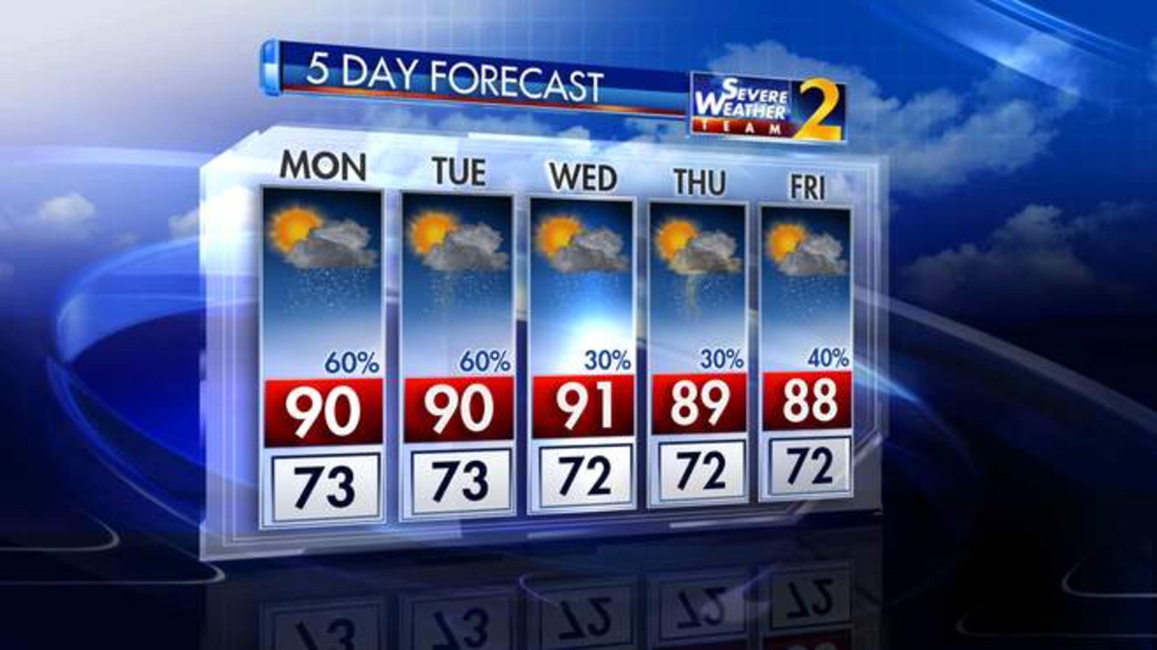
ATLANTA FORECAST
Monday: High: 87
Monday night: Low: 76
Tuesday: High: 89
» For a detailed forecast, visit The Atlanta Journal-Constitution weather page.
ORIGINAL STORY: Any afternoon showers affecting the metro area should be long gone by the evening, according to Channel 2 Action News.
But don’t put that umbrella away just yet.
While showers are largely east and north of Atlanta, "a little patch of" rain is expected on the westside by 11 p.m., according to Channel 2 Action News meteorologist Brian Monahan.
Showers were in DeKalb, north Fulton, Gwinnett and Henry counties, according to the news station.
A thunderstorm warning issued by the National Weather Service for Clayton, Henry and Spalding counties expired at 9:30 p.m.
Drenched areas could receive between one and two inches of rain, Monahan said.
Tracking heavy rain over Newton, Butts, Henry Counties... tracking live on @wsbtv next at 5. pic.twitter.com/6O4KEeN1Ks
— Brian Monahan, WSB (@BMonahanWSB) July 16, 2018

“The main impact from storms today will be heavy rain and frequent lightning — these storms will be slow-moving,” Monahan said.
Evening commuters are in for a wet drive.
Earlier delays remained after crashes along the Downtown Connector just south of 17th street and I-285 West near Ga. 400 left the interstates at a standstill.
A six-vehicle wreck on the Connector had delays as far back as the Buford-Spring Connector, according to the WSB 24-hour Traffic Center. Delays also remained on I-285 near the Ga. 400 southbound ramp after a crash blocked two right lanes. Both wrecks have cleared.
Downtown traffic is getting some relief now that Spring Street is back open. Last week’s work to remove a crane is now completed.
And it’s the last day of the AmericasMart show, which has brought daily traffic jams near the showroom on Williams Street.
More clouds and showers today means more temperatures in the mid to upper 80s instead of the 90s. pic.twitter.com/pRmbB0RvQ6
— Karen Minton (@KarenMintonWSB) July 16, 2018
So far, two wrecks on I-85 near Steve Reynolds Boulevard in Gwinnett County and Shallowford Road in DeKalb County have led to delays.
Expect a hot and humid commute as rain and clouds will help keep temperatures in the mid- to upper 80s instead of the 90s, according to Channel 2. In the city, it is muggy and 85 degrees. The city reached a projected high of 87.
While storms are expected to diminish by the evening, Monday’s downpours could lead to damage similar to that caused by Sunday’s storms, according to Channel 2.
“Yesterday, these storms dropped (at least) 2 inches of rain in some parts of the area,” Monahan said. “That potential is there again today. Some storms will last into the evening hours.”
Overnight Sunday, storms downed trees and caused the creek at Logan Farm Park in Acworth to swell, flooding the park. Cleanup continues Monday, Channel 2 reported.
Cleanup underway after flooding and trees down in Acworth. 4pm pic.twitter.com/lnvAc64NNP
— Berndt Petersen (@BPetersenWSB) July 16, 2018
While Tuesday is expected to see more scattered storms, Monahan said Atlanta should get a small break in the rain Wednesday and Thursday.
“Drier air starts drifting toward the area tomorrow, but it will still stay wet at times with the chance of rain at 60 percent,” Monahan said. “By Wednesday and Thursday, the most significant moisture pushes to the south of the area and we’ll have just isolated storms each day with highs returning the low 90s.”
Another 1-2 inches of rain possible this week. Acworth and Kennesaw picked up 2-3" Sunday. So far the rain surplus for Atlanta is 6.09". The area will get a small break in the rain Wednesday and Thursday. pic.twitter.com/1clV8FdJLe
— Karen Minton (@KarenMintonWSB) July 16, 2018
» For updated traffic information, listen to News 95.5 and AM 750 WSB and follow @ajcwsbtraffic on Twitter.
» Download The Atlanta Journal-Constitution app for weather alerts on-the-go.
About the Authors