WEATHER-TRAFFIC UPDATE: Wrecks, stalled vehicles cause delays during evening commute
A series of wrecks and stalled vehicles are causing backups on metro Atlanta's interstates during the evening commute, the WSB 24-hour Traffic Center reported.
In DeKalb County, a HERO unit is blocking the eastbound lanes of I-285 at Ashford Dunwoody Road as crews work to remove a stalled tractor-trailer from the left lane.
DeKalb Co: HERO units holding lanes on I-285/eb (Inner Loop) at Ashford Dunwoody Rd (Exit 29) to clear a stalled big rig out of the left lane. Tough delays before GA-400. #ATLtraffic pic.twitter.com/EjTLuYlHnk
— AJC WSB Traffic (@ajcwsbtraffic) June 12, 2019
Heading into the city, all southbound lanes of I-75 were blocked at Howell Mill Road as police removed an earlier wreck, according to the Traffic Center.
TRAVEL ADVISORY Fulton Co.: Crash..I-75/sb at Howell Mill Rd (Exit 252), all lanes being held to clear crash out of roadway. Use Hwy 41/ Northside Dr as an alternate. https://t.co/oChLshdbT4 #ATLtraffic pic.twitter.com/3jbntYx17W
— AJC WSB Traffic (@ajcwsbtraffic) June 12, 2019
And in Marietta, a wreck on I-75 North between North Marietta Parkway and Canton Road is causing delays.
Cobb Co: Crash...I-75/nb between the N 120 Loop & Hwy 5. Off to the left but still adding to delays as you leave I-285. #ATLtraffic https://t.co/j2xHL1ZFrc pic.twitter.com/3p0eTyDC8L
— AJC WSB Traffic (@ajcwsbtraffic) June 12, 2019
Earlier this afternoon, a Jet Ski fell off a vehicle and into the roadway, causing delays in Gwinnett County.
Gwinnett Co: Crash...Peachtree Industrial Blvd/nb at Winters Chapel Rd. Left lane blocked. Delays leaving I-285. #ATLtraffic pic.twitter.com/qWW1IUEdmn
— AJC WSB Traffic (@ajcwsbtraffic) June 12, 2019
The wayward watercraft blocked one left lane of Peachtree Industrial Boulevard at Winters Chapel Road, causing backups for drivers getting off I-285.
As for the weather, showers across metro Atlanta have made temperatures outside feel more like April than June.
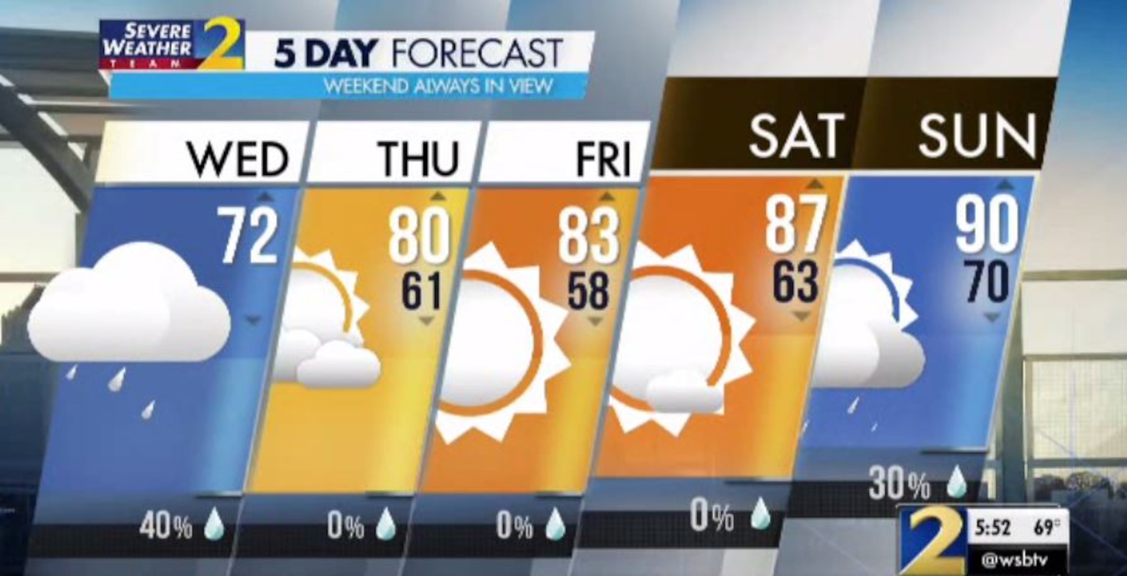
The afternoon high topped out at 74 degrees and has since dropped to 72, Channel 2 Action News meteorologist Brad Nitz said.
More rain is expected Wednesday as storms from Alabama move into west Georgia.
The good news is that it shouldn’t be anything like North Georgia saw Tuesday night.
Showers and downpours moving through the state Tuesday stalled and became stationary, dumping up to 3 inches of rain in some spots. Forsyth and DeKalb counties saw the worst of it, prompting flash flood warnings overnight.
There is a slight threat of isolated severe storms, heavy rain and wind gusts as strong as 60 mph in the west Georgia counties, Nitz said. The inclement weather should linger for the next couple of hours before dissipating.
“After 7, as this moves farther to the east, we keep a couple of isolated showers around, but the intensity will be dropping off,” Nitz said.
A cold front moving in overnight should bring an end to metro Atlanta’s string of wet weather, he said.
“I don't expect much of anything in the way of rain as this cold front moves on by, and behind it, beautiful weather is settling in for the end of the week,” Channel 2 meteorologist Brian Monahan said.
Monahan said Thursday will “completely flip the story around from clouds and showers (Wednesday) to sunshine and warmer temperatures.”
There is less than a 10 percent chance of showers Thursday, and afternoon highs are forecast in the low 80s. The rain chance drops out of the forecast for Friday and Saturday, but isolated storms are 30 percent likely Sunday, according to Channel 2.
“As we move into the weekend we've got temperatures warming up across North Georgia,” Monahan said. Sunday’s high for Atlanta is a projected 90 degrees.
» For a detailed forecast, visit The Atlanta Journal-Constitution weather page.
» For updated traffic information, listen to News 95.5 and AM 750 WSB and follow @ajcwsbtraffic on Twitter.
» Download The Atlanta Journal-Constitution app for weather alerts on-the-go.
About the Authors


