WEATHER-TRAFFIC UPDATE: Scattered storms in north metro Atlanta; severe storms expected
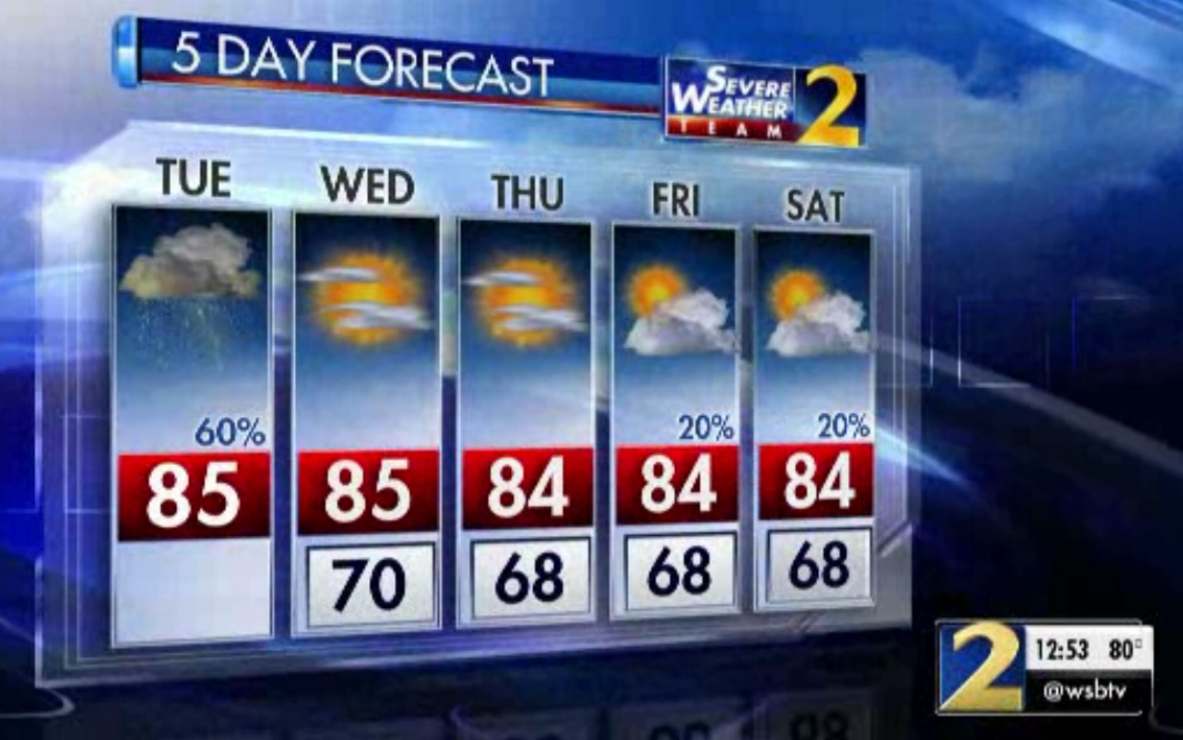
ATLANTA FORECAST
Tuesday: High: 85
Tuesday night: Low: 70
Wednesday: High: 85
» For a detailed forecast, visit The Atlanta Journal-Constitution weather page.
A cold front has begun to enter the Atlanta area, keeping temperatures low and increasing the chance of strong storms later this afternoon.
Don’t mistake lower temperatures for a breezy, cool day outside though. The temperature is currently in the mid-80s, but the heat index is at 89 degrees in Atlanta.
Quite a few storms now developing in metro along I85. Main impacts will be heavy rain and frequent lightning. @GlennBurnsWSB is tracking for you. pic.twitter.com/AiS9xnzx8K
— Brian Monahan, WSB (@BMonahanWSB) August 21, 2018
There’s a few scattered storms in the northern metro area, and those storms are making their way east, Channel 2 Action News reported.
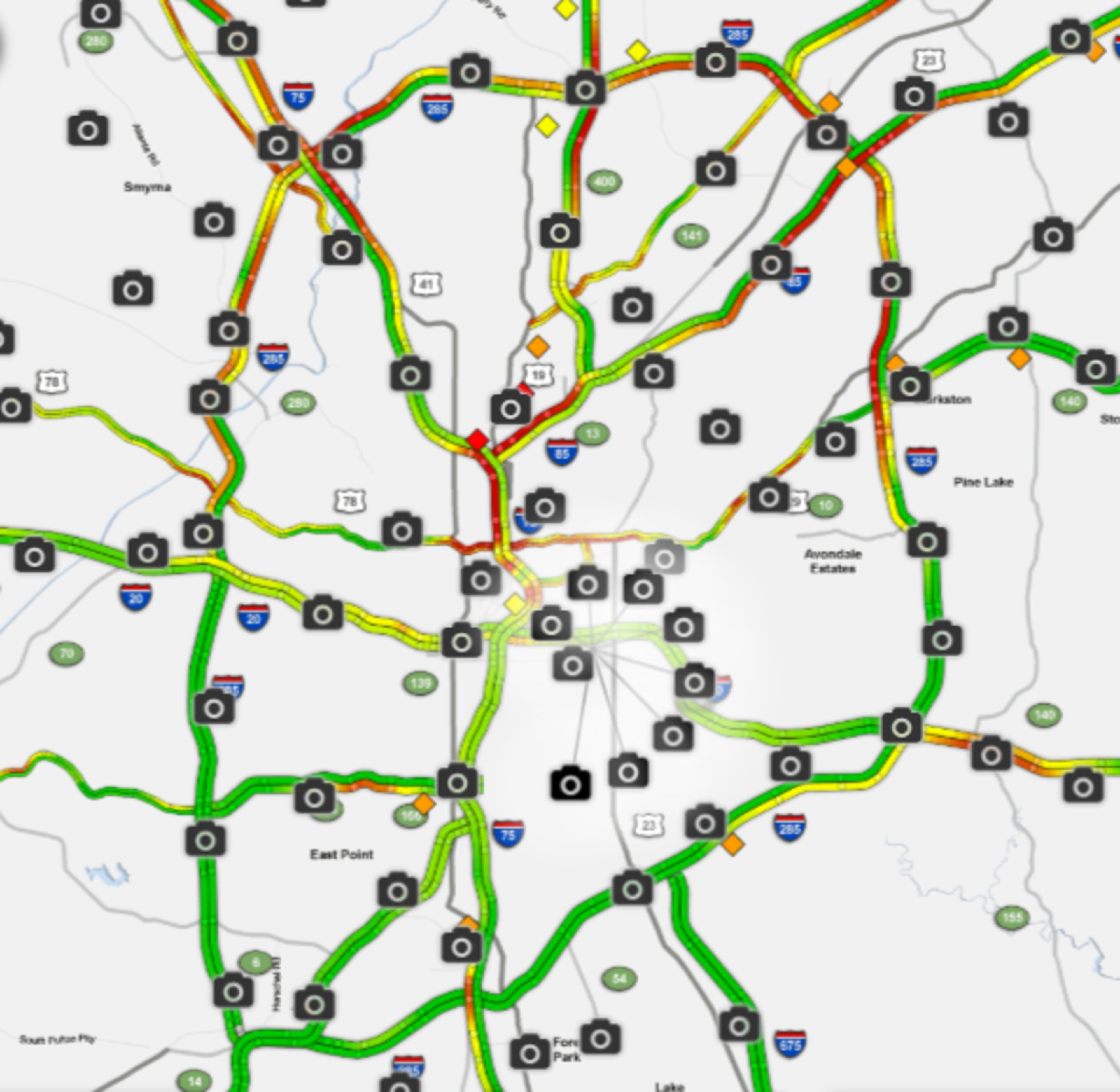
That means metro Atlanta roadways are mostly dry for now, but the Downtown Connector is riddled with issues, according to the WSB 24-hour Traffic Center.
Road construction that has two lanes of Peachtree Road shut down between Palisades Road and 26th Street is causing heavy delays as well, the Traffic Center reported.
Midtown: Peachtree Rd/sb at 26th St; 2 right lanes still blocked by road work; heavy delays back to Peachtree Battle https://t.co/2hvjWkI3bV #ATLtraffic pic.twitter.com/iPWztBLd7g
— AJC WSB Traffic (@ajcwsbtraffic) August 21, 2018
The Northern Perimeter is also beginning to see the effects of the evening commute, the Traffic Center reported.
Damaging winds are the primary concern now that the cold front has reached metro Atlanta, and heavy rain is possible, too, according to Channel 2.
The front could produce between 40 and 60 mph winds, small hail and lightning. Channel 2 meteorologist Karen Minton said strong storms are likely, and some could turn severe.
Scattered showers and storm today, but drier air is coming. I'm tracking a cold front on @wsbtv at noon and 5 pm. pic.twitter.com/bGsBlDaNPR
— Brad Nitz (@BradNitzWSB) August 21, 2018
“The Storm Prediction Center took northeast Georgia out of risk of organized severe storms but can’t rule out that one of these could turn that way,” Minton said. “So stay weather-aware as we head through the late evening hours.”
The last line of storms is expected to roll through about 8 p.m. After that, northwest Georgia should start to feel the first hints of lower humidity, Minton said.
Scattered showers and storms today, rainfall totals generally less than 1/2". I'll be tracking on @wsbtv. pic.twitter.com/1qPIHiHfGE
— Brad Nitz (@BradNitzWSB) August 21, 2018
“There's dry air coming in behind this thing and as it sweeps in, the clouds are going to start to clear, the dew points are going to start dropping, the temperatures will be feeling great,” she said.
Through Friday, it should be cooler and mostly rain-free.
We get to enjoy a few dry days this week in Georgia. By the end of August beginning of September we will have a few more dry days...but temperatures will reach above normal during that phase. pic.twitter.com/k7SBvDZbd7
— Karen Minton (@KarenMintonWSB) August 21, 2018
Temperatures are expected to be in the mid-80s the rest of this week, according to Channel 2. Commuters can expect lows in the 60s and 70s during their drive to work.
» For updated traffic information, listen to News 95.5 and AM 750 WSB and follow @ajcwsbtraffic on Twitter.
» Download The Atlanta Journal-Constitution app for weather alerts on-the-go.
About the Authors


Zachary Hansen, a Georgia native, covers economic development and commercial real estate for the AJC. He's been with the newspaper since 2018 and enjoys diving into complex stories that affect people's lives.