LIVE WEATHER-TRAFFIC: Severe thunderstorm warnings expire in North Georgia; rain leaves Atlanta
[7 p.m.]: The severe thunderstorm warning for Murray and Whitfield counties has expired, leaving no active warnings in North Georgia.
[6:30 p.m.]: The severe thunderstorm warnings for Chattooga, Floyd, Gordon and Walker counties have expired. However, a warning for Murray and Whitfield counties was issued until 7 p.m.
[5:45 p.m.]: The severe thunderstorm warning for DeKalb, Fulton and Gwinnett counties expired. However, a severe thunderstorm warning was issued for Chattooga, Floyd, Gordon and Walker counties about the same time, which will expire at 6:15 p.m.
[5:24 p.m.]: The severe thunderstorm warning for DeKalb and Fulton counties has been extended until 5:45 p.m., and Gwinnett County is also under the warning, according to the National Weather Service.
UPDATE [4:56 p.m.]: A severe thunderstorm warning has been issued for DeKalb and Fulton counties until 5:30 p.m.
ORIGINAL STORY: Atlanta is no longer dry as storms begin to move through midtown, according to Channel 2 Action News.
The storms aren’t severe, unlike the system that moved through Cobb County within the past hour, which led to hail falling in Marietta, Channel 2 reported. Coweta, Fayette and Haralson counties were also under a severe thunderstorm warning earlier in the afternoon.
While rain hasn’t been omnipresent Thursday, traffic troubles have been.
Cobb traffic is recovering after construction blocked a right lane of I-75 North near Wade Green Road, the WSB 24-hour Traffic Center reported. The lane has reopened, but the interstate didn't get much time to recover before the evening commute.
The Perimeter is also very slow after several westbound lanes were blocked at Ashford Dunwoody Road in DeKalb County. A driver sped off from a traffic stop, dragging a Dunwoody police officer alongside a vehicle.
RELATED: Police officer dragged by car on I-285; suspect in custody
The incident resulted in secondary crashes, according to police. While authorities were on scene, multiple lanes were blocked and the entrance ramp to Ashford Dunwoody was also shut down. The activity has been cleared and all lanes have reopened, but the area is still slow.
The rain is starting to affect I-285, I-20 and the Downtown Connector as well, the Traffic Center reported.
Most bus stops were dry Thursday morning as districts across metro Atlanta returned to school, but the weather has soured as kids make their way home, according to Channel 2.
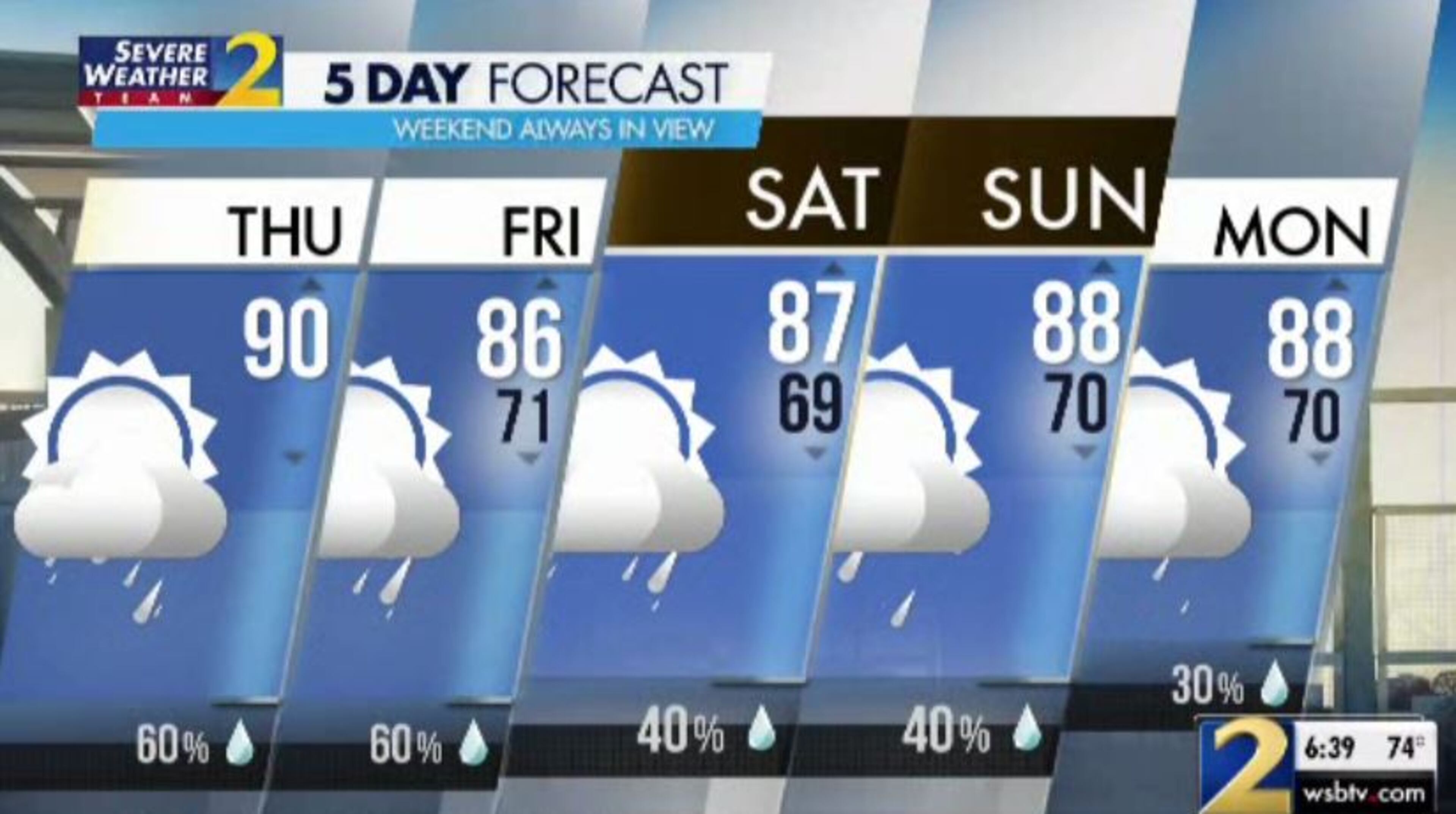
“The calendar says we're back to school, but it is still the heart of summertime here on the first day of August,” Channel 2 meteorologist Brian Monahan said. “Summertime means those storms popping up in the afternoon.”
A cold front stalled to the north will keep Georgia warm and humid, creating ideal conditions for a scattering of afternoon storms. The storm chance is 60% for all of metro Atlanta.
Monahan expects the downpours and thunderstorms to last through the late evening. Like on Wednesday, Monahan said the rain will continue into the 10 p.m. hour before things quiet down overnight.
“We'll start mainly dry Friday morning, but more storms coming for the afternoon,” he said.
Friday also carries a 60% chance of rain, according to Channel 2.
“Rain chances 40% to 60% straight through the weekend,” Monahan said. “That will mean slightly cooler temperatures as we head toward Saturday and Sunday with highs in the mid- to upper 80s.”
» For a detailed forecast, visit The Atlanta Journal-Constitution weather page.
» For updated traffic information, listen to News 95.5 and AM 750 WSB and follow @ajcwsbtraffic on Twitter.
» Download The Atlanta Journal-Constitution app for weather alerts on-the-go.
About the Authors


Zachary Hansen, a Georgia native, covers economic development and commercial real estate for the AJC. He's been with the newspaper since 2018 and enjoys diving into complex stories that affect people's lives.

