FRIDAY’S WEATHER-TRAFFIC: Not everyone will see rain today
North Georgia is emerging from what has been a wet week with a little more sunshine in the forecast Friday.
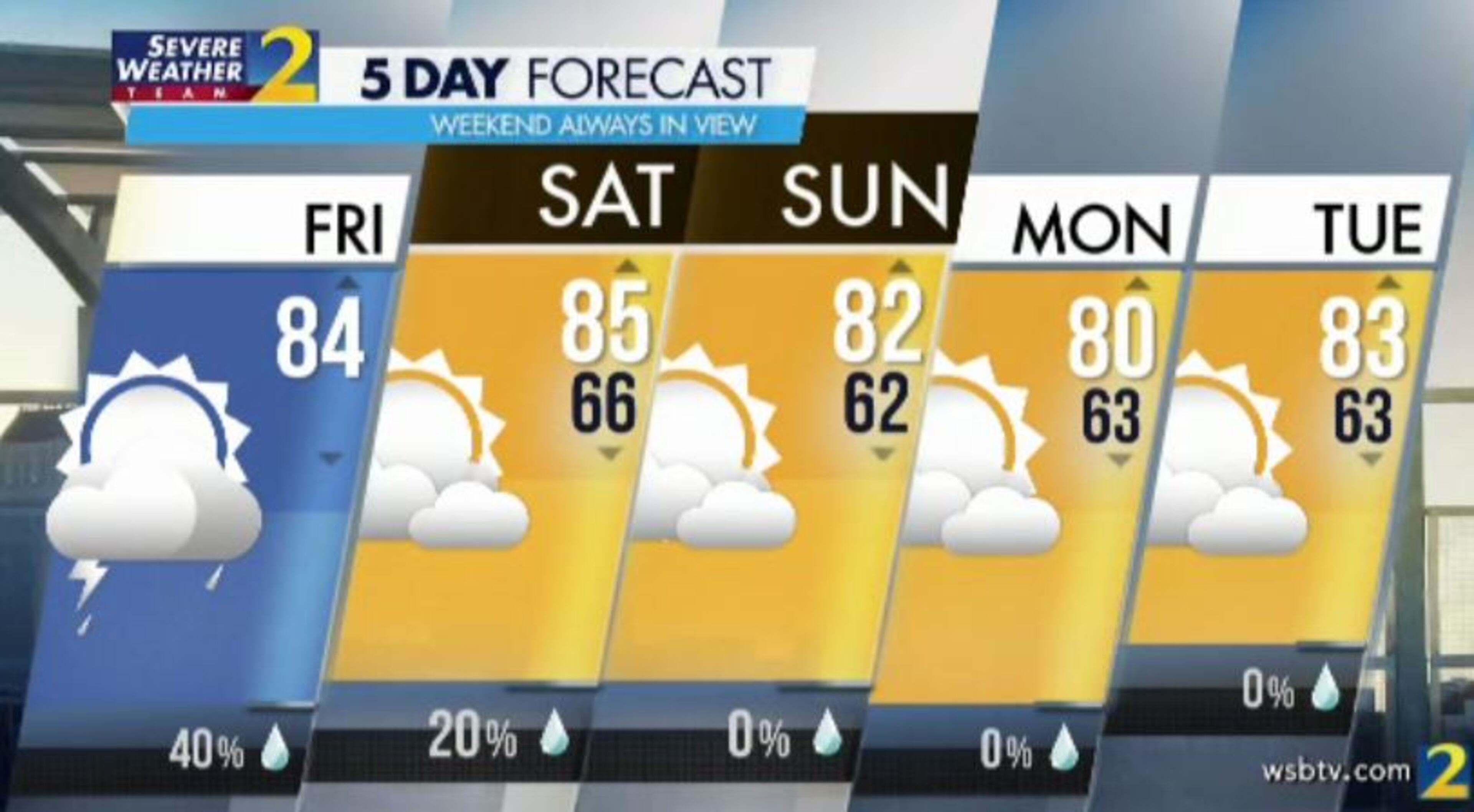
A cold front expected at midday should mean even better things for the weekend, according to Channel 2 Action News. The rain chances go from 40% Friday to just 20% Saturday and completely drop out of the forecast on Sunday.
Channel 2 meteorologist Brian Monahan said areas east of Atlanta will have the best chance of an isolated thunderstorm Friday.
“This isn’t one of those days where everybody is going to see rain,” he said. “Some of us will get through today completely dry.”
An area of low pressure that has dominated Georgia’s weather this week is weakening and moving away, but Monahan said it is not far enough away to keep everyone dry. Showers are falling on the Eastside to begin the day, and there will be another shot at rain once temperatures rise Friday afternoon, he said.
The approaching cold front will trigger some downpours by about 3 p.m., according to Channel 2. North Georgia is not likely to see a repeat of Thursday’s severe thunderstorms.
“That risk is not nearly as high as it was yesterday,” Monahan said. “We'll keep things in the thundershower variety of rain later on this afternoon.”
Temperatures will be lowest Friday from Athens to Gainesville, which have the best chance for rain, according to Channel 2. Metro Atlanta should make it to a projected high of 84 degrees.
Monahan said the humidity will make it feel even warmer.
“Once the clouds break, once you get a little sunshine in your neighborhood, the effect of the humidity and the sunshine will make it feel like it’s more in the mid- to a few upper 80s,” he said.
Once the cold front moves by, most of North Georgia will get a chance to dry out. Monahan said it looks great for any Friday night plans after sunset.
It should be dry all the way through the middle of next week, he said. A dry change in the weather pattern for all of the Southeast could mean higher temperatures are on the horizon.
“I do see a chance of 90s in the second half of next week,” he said,
Highs in the 80s are in the forecast through the weekend, but Saturday should feel a little more comfortable with lower humidity, according to Channel 2.
A tree down in Cherokee County is the biggest traffic problem Friday morning, according to the WSB 24-hour Traffic Center.
“That’s actually not too bad,” traffic reporter Mark Arum said. “The interstates are delay-free.”
The tree is blocking Cumming Highway at Old Cumming Road. Once drivers make it to I-575, the ride is easy all the way to I-285, the Traffic Center reported.
Even the Perimeter is clear Friday morning, Arum said at 6 a.m.
That will change in a few hours with the arrival of Vice President Mike Pence. Air Force Two is expected to touch down at Dobbins Air Reserve Base in Marietta about 10 a.m.
Interstates and surface streets will be closed as Pence's motorcade travels from Marietta to Buckhead for the memorial service of Christian evangelist Ravi Zacharias.
RELATED: Pence to return to Atlanta for second time in a week
After the service, Pence is scheduled to meet with small business owners before returning to the base in Marietta.
» For a detailed forecast, visit The Atlanta Journal-Constitution weather page.
» For updated traffic information, listen to News 95.5 and AM 750 WSB and follow @ajcwsbtraffic on Twitter.
» Download The Atlanta Journal-Constitution app for weather alerts on-the-go.
About the Author


