LIVE WEATHER-TRAFFIC: Severe thunderstorm warnings canceled for east metro Atlanta counties
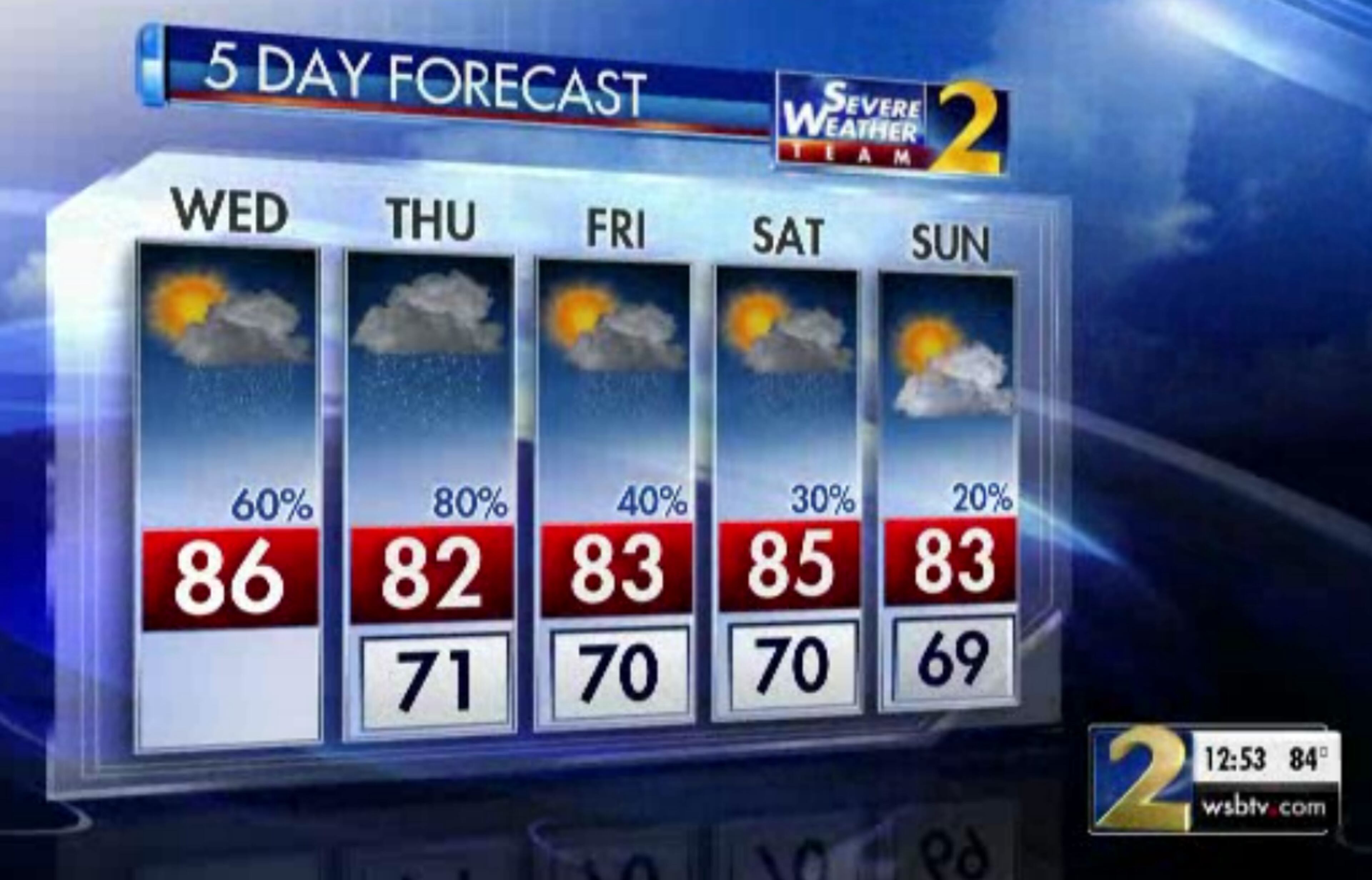
ATLANTA FORECAST
Wednesday: High: 86
Wednesday night: Low: 71
Thursday: High: 82
» For a detailed forecast, visit The Atlanta Journal-Constitution weather page.
[5:43 p.m.]: The severe thunderstorm warnings have been canceled for Gwinnett, Hall, Barrow and Jackson counties.
[5:41 p.m.]: All I-75 North lanes have reopened after a fiery tractor-trailer crash in Cobb County.
MORE: I-75 lanes reopen after fiery tractor-trailer crash injures 1 in Cobb
[5:20 p.m.]: A tree that fell on MARTA's Gold line track has been removed, according to a tweet.
Update: Fallen tree removed at Cham & Brookhaven. At Brookhaven, SB trains resumed boarding on the SB-Read more: https://t.co/CCatdIAX5H
— MARTA (@MARTASERVICE) September 26, 2018
[5:19 p.m.]: A vehicle fire on I-75/I-85 North near Peachtree Road has blocked two right lanes, the Traffic Center reported. Delays span back before University Avenue.
#TRAVELADVISORY I-75/85/nb n of P'tree/Pine (exit 249), vehicle fire being doused two right lanes. Jammed before University Ave. (exit 244). #ATLtraffic https://t.co/2hvjWkI3bV pic.twitter.com/XHJUwRSV5J
— AJC WSB Traffic (@ajcwsbtraffic) September 26, 2018
UPDATE [5:13 p.m.]: Severe thunderstorm warnings have been issued for Gwinnett, Hall, Barrow and Jackson counties until 6 p.m. by the National Weather Service.
Severe Thunderstorm Warning including Winder GA, Buford GA, Braselton GA until 6:00 PM EDT pic.twitter.com/BgylvLW1Zy
— NWS Atlanta (@NWSAtlanta) September 26, 2018
ORIGINAL STORY: A wave of heavy rain is slowly moving through metro Atlanta, and the storms are starting to affect traffic and cause other problems.
It's looking like a wet evening commute, according to the WSB 24-hour Traffic Center.
THIS is a messy evening commute. Heaviest rain now pushing across and now just east of the downtown connector.@GlennBurnsWSB has another radar update at 4:45 on Channel 2. @wsbtv pic.twitter.com/yH16cEiND7
— Brian Monahan, WSB (@BMonahanWSB) September 26, 2018
“Part of the commute is going to be rather messy,” Channel 2 Action News meteorologist Karen Minton said.
A tree has also fallen on the southbound MARTA tracks between the Chamblee and Brookhaven stations, which is causing delays on the Gold line, MARTA said in a tweet.
Single-tracking is in effect, and delays are about 10 minutes from the Chamblee station to Lindbergh Station and from the Lenox station to Doraville station, MARTA spokeswoman Stephany Fisher told AJC.com.
Due to a fallen tree on the SB track way between Cham & Brookhaven, delays are occurring on the Gold line.
— MARTA (@MARTASERVICE) September 26, 2018
The Traffic Center reported that I-20, I-285 and I-75 are all seeing effects from the rain.
Only the right lane of I-285 North is open near La Vista Road after a crash and vehicle fire, which is causing heavy delays, the Traffic Center reported. Two southbound left lanes are also blocked in the area.
#GRIDLOCKALERT Just right lane barely open with this scattered crash and vehicle fire I-285/nb (Outer Loop) n of LaVista (exit 37) and now two left lanes blocked I-285/sb in area. Major delays. #ATLtraffic https://t.co/2hvjWkI3bV pic.twitter.com/7o9Wthk8Zx
— AJC WSB Traffic (@ajcwsbtraffic) September 26, 2018
Marietta police said North Marietta Parkway between Roswell Road and Wallace Road has lanes closed in both directions because of an overturned vehicle.
AVOID N. Marietta Pkwy between Roswell Rd and Wallace Rd. An overturned vehicle has lanes closed, both directions. https://t.co/Wu7Otv7D1s
— Marietta Police (@MariettaPD) September 26, 2018
Ga. 166 is also flooding near DeLowe Drive and Stanton Road, and all lanes are affected, according to the Georgia Department of Transportation.
ALERT: Road Flooding; SR 166 WB: DeLowe Dr/Stanton Rd (MP 59), Fulton Co, all lns aff, Ocrd: 4:35PM, Exp clr: 8PM.| 4:39P
— GDOT Atl Traffic (@GDOTAtlTraffic) September 26, 2018
The rain is further complicating issues on I-75 North near Chastain Road, which is gridlocked because of a multi-vehicle wreck, including a tractor-trailer that was on fire.
MORE: Tractor-trailer fire causing I-75 lane closures in Cobb
Lanes now open https://t.co/tzguRbBbnQ
— Cobb County DOT (@CobbDOT) September 26, 2018
The weather front is bringing more rain to already soggy northwest Georgia. The National Weather Service has issued a flash flood watch for 15 northwest Georgia counties, including Polk, Floyd, Bartow, Gordon and Pickens.
The region has already seen 3 to 5 inches of rainfall over the past few days, Minton said. Pickens and Bartow counties are also under flash flood warnings until 8 p.m.
Flash Flood Watch for Pickens and Bartow County until 8:00pm EDT Thursday.
— Kirk Mellish (@MellishMeterWSB) September 26, 2018
“More rain falling just means runoff,” Minton said. “It can’t soak into the ground, so it is going to be running off, which could pose some problems for the creeks and the streams in these areas.”
An additional 2 to 3 inches of rain is expected to fall, with isolated spots getting 4 more inches. The flash flood watch is in effect through Thursday night.
FLASH FLOOD WATCH: A flash flood watch is in effect for northwest Georgia through tomorrow evening.
— Brian Monahan, WSB (@BMonahanWSB) September 26, 2018
Parts of this area have picked up 3-5" of rain so far, and another 2-3" is possible. Flooding of rivers, creeks, and streams possible. @wsbtv pic.twitter.com/Te9BIsrJyY
The cold front is expected to dominate North Georgia weather over the next several days.
“It’s going to be sliding into the state, but it is going to continue to be slow-moving, so not everyone is going to get it all at once,” she said.
Wednesday has a 60 percent chance of scattered storms, and Thursday’s chance goes up to 80 percent. The rain chances diminish through the end of the week, but the wet weather is not expected to begin to clear until Sunday, according to Channel 2.
Cold front is not that far away from us right now -- over western Kentucky and Tennessee... but it's going to take a long time to get close to us. That means high rain chances the next couple of days!
— Brian Monahan, WSB (@BMonahanWSB) September 26, 2018
What the front won’t bring is cold air.
The temperature should still reach the mid-80s, which is about five degrees warmer than average.
Average highs are in the upper 70s now in north Georgia -- we'll be a bit above that the next several days, but much closer to where we should be this time of year.
— Brian Monahan, WSB (@BMonahanWSB) September 26, 2018
The warmer weather will be especially noticeable in the morning hours. On average, the Atlanta morning low temperature for this time of year is about 61 degrees. It was 13 degrees warmer than that Tuesday, according to Channel 2.
» For updated traffic information, listen to News 95.5 and AM 750 WSB and follow @ajcwsbtraffic on Twitter.
» Download The Atlanta Journal-Constitution app for weather alerts on-the-go.
About the Authors

Zachary Hansen, a Georgia native, covers economic development and commercial real estate for the AJC. He's been with the newspaper since 2018 and enjoys diving into complex stories that affect people's lives.


