WEATHER-TRAFFIC UPDATE: Overcast skies, few sprinkles as evening commute begins
ATLANTA FORECAST
Tuesday: High: 81
Tuesday night: Low: 71
Wednesday: High: 80
» For a detailed forecast, visit The Atlanta Journal-Constitution weather page.
Despite the ominous overcast sky, only a few sprinkles are falling this afternoon in metro Atlanta.
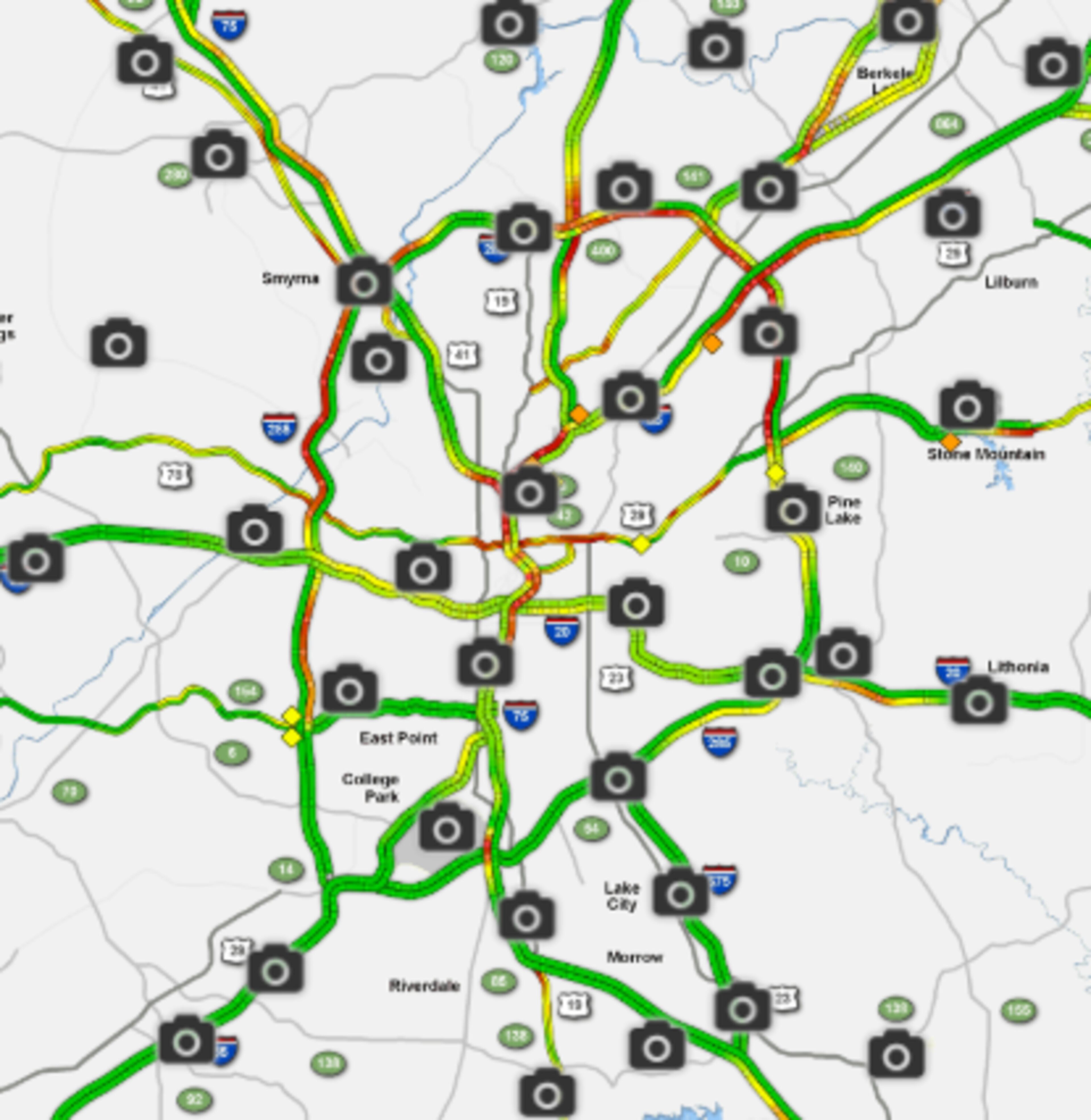
But traffic is getting heavy as the evening commute begins, according to the WSB 24-hour Traffic Center.
Construction on Peachtree Street isn’t helping matters. A right northbound lane is closed between 26th Street and Palisades Road, the Traffic Center reported.
In Henry County, all but the far left lane of I-75 North near Ga. 20 is blocked by a crash, causing heavy delays, according to the Traffic Center.
Henry Co: I-75/nb past Hwy 20/81 (exit 218); crash only letting the far left alane by; heavy delays; use Hwy 23 or Hwy 41 as alternates https://t.co/2hvjWkI3bV #ATLtraffic pic.twitter.com/BbKcYKshcn
— AJC WSB Traffic (@ajcwsbtraffic) October 9, 2018
Georgia is feeling some early effects of Hurricane Michael with high humidity and 15-20-mph winds, according to Channel 2 Action News.
All eyes are on Michael as the hurricane bears down on the Florida Panhandle. The storm became a Category 3 hurricane Tuesday afternoon and is expected to make landfall Wednesday, bringing heavy rain, high winds and possible flooding into Georgia as it makes its track inland, according to the National Hurricane Center.
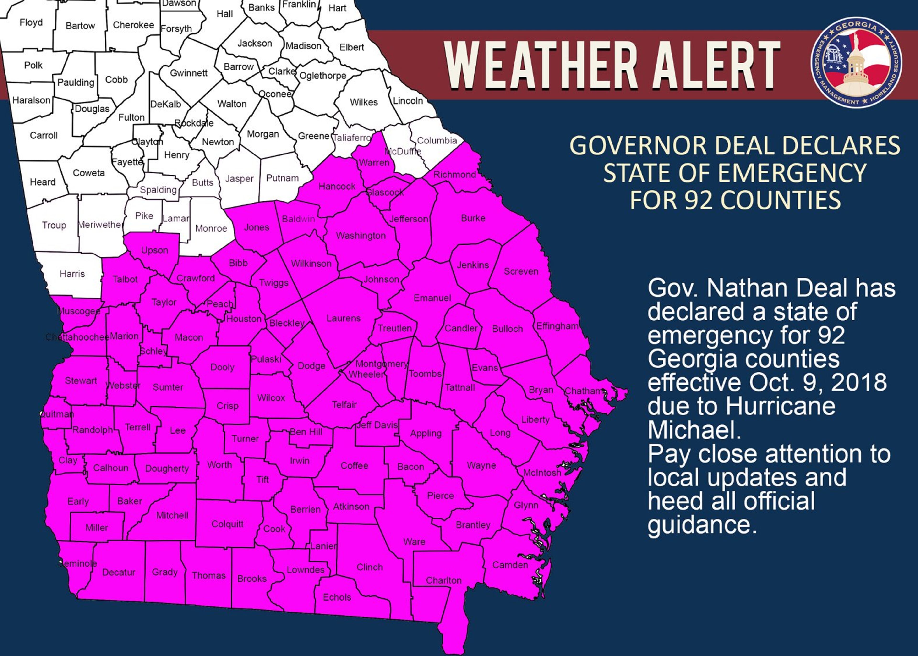
MORE: State of emergency declared for 92 Georgia counties ahead of Hurricane Michael
JUST IN:
— Brad Nitz (@BradNitzWSB) October 9, 2018
Hurricane Michael is a major category 3 hurricane now. Sustained wind 120 mph, gusts to 150 mph.
The new track on @wsbtv at 5pm. pic.twitter.com/SF6YkzWb9O
Gov. Nathan Deal declared a state of emergency for 92 Georgia counties mostly south of Macon on Tuesday.
RELATED: What is a state of emergency? Georgia braces for Hurricane Michael
“For us today, we’re just looking at a lot of clouds,” Channel 2 meteorologist Karen Minton said. “It will be breezy. There will be some scattered showers here and there, but that’s about all we'll be seeing for today, with temperatures holding a little cooler than we’ve seen.”
Atlanta has reached its projected high Tuesday of 81 degrees, which is about 5 degrees cooler than it was in North Georgia this time last week.

Hurricane Michael is expected to bring lots of rain into Georgia on Wednesday when it passes through the state as a tropical storm. The NHC said the heaviest rain will be along the storm track to the south and east of Atlanta, with 3 to 6 inches of rain possible.
RELATED: The time to prepare for Hurricane Michael is right now
Due to Hurricane Michael there is a risk for severe storms with damaging winds, heavy rain and even an isolated tornado for areas in yellow. Stay with WSB-TV for updates this week. #StormWatchOn2 pic.twitter.com/VYgnhGeWJa
— Karen Minton (@KarenMintonWSB) October 9, 2018
A flash flood watch has been issued for the southeast portion of the state, according to Channel 2.
RELATED: How dangerous is a hurricane? Understanding hurricane categories
FLASH FLOOD WATCH: 3"-5" of rain possible with isolated 6"-7". This is due to Hurricane Michael which will make landfall along the panhandle of Florida sometime on Wednesday and spread rain across Georgia. pic.twitter.com/WJBAOWojO7
— Karen Minton (@KarenMintonWSB) October 9, 2018
Less rain is expected northwest of Atlanta, but it will still be plenty wet. The chance of rain increases from 30 percent Tuesday to 100 percent Wednesday and 90 percent Thursday.
Hurricane Michael is expected to be a tropical storm as it passes southeast of Atlanta. It will bring the heaviest rain to our counties southeast of metro. 3"-5" of rain possible in orange, isolated 6"-7" possible. Much less rain NW of Atlanta. pic.twitter.com/XI6qEUFsx2
— Karen Minton (@KarenMintonWSB) October 9, 2018
The central and south portions of the state could also see high 40-60-mph winds. Wind gusts of nearly 40 mph were recorded near the Florida Panhandle at 11 a.m. Tuesday, according to Channel 2.
The National Hurricane Center has issued hurricane and tropical storm warnings and tropical storm watches for parts of South Georgia.
RELATED: Georgia DOT: Avoid interstates when evacuating for Hurricane Michael
Hurricane Warnings, Tropical Storm Warnings and Tropical Storm Watches are already posted for parts of south Georgia. pic.twitter.com/vK4UvqFJiZ
— Karen Minton (@KarenMintonWSB) October 9, 2018
As Michael heads out of the state Thursday, it is expected to take all the wet weather and humidity with it. Fall-like temperatures and sunshine are on tap for the weekend, Minton said.
“By Friday, it’s settling down,” Minton said. “And by Saturday, it’s gorgeous.”

» For updated traffic information, listen to News 95.5 and AM 750 WSB and follow @ajcwsbtraffic on Twitter.
» Download The Atlanta Journal-Constitution app for weather alerts on-the-go.
About the Authors


Zachary Hansen, a Georgia native, covers economic development and commercial real estate for the AJC. He's been with the newspaper since 2018 and enjoys diving into complex stories that affect people's lives.

