WEATHER-TRAFFIC UPDATE: Dry, sunny evening commute marred by roadwork, wrecks
ATLANTA FORECAST
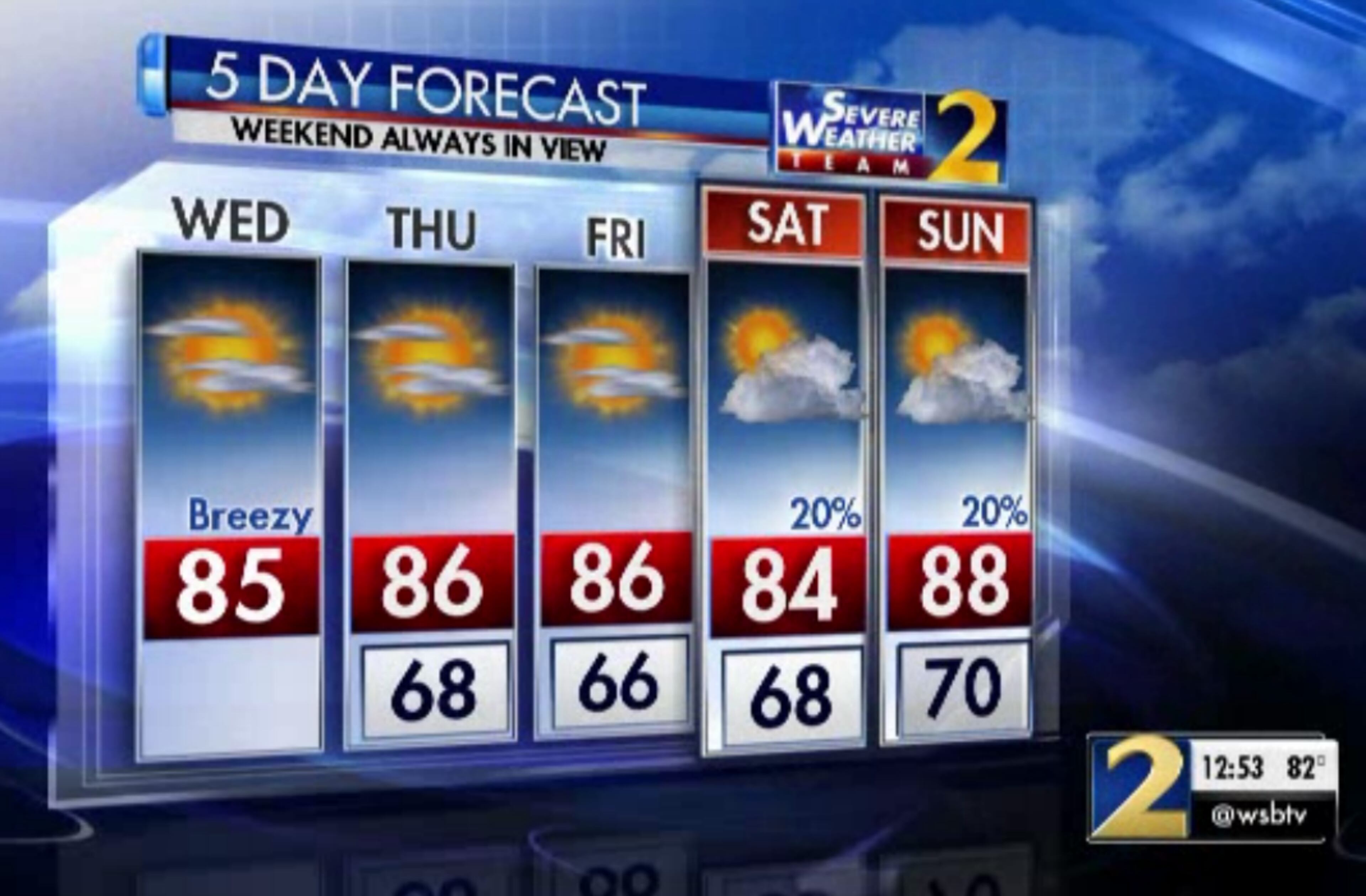
Wednesday: High: 85
Wednesday night: Low: 68
Thursday: High: 86
» For a detailed forecast, visit The Atlanta Journal-Constitution weather page.
Georgians couldn’t ask for a better summer day. It’s dry, not too humid and there isn’t a rain cloud in sight.
However, Atlanta’s interstates aren’t having nearly as good of a day.
Closures continue on Peachtree Street. All southbound lanes of Peachtree Street at 26th Street will be blocked at times Wednesday for a Georgia Department of Transportation project. Delays are expected to be heavy, according to the WSB 24-hour Traffic Center. Take Northside Drive as an alternate route.
TRAVEL ADVISORY: Fulton Co.: Construction: Peachtree St/sb at 26th St; only a left lane is open; heavy delays; use Northside Dr.; https://t.co/kTgeaYu0Zi; #ATLtraffic pic.twitter.com/A3WWHT2Cux
— Triple Team Traffic (@WSBTraffic) August 22, 2018
Wrecks on I-20 in Newton and Douglas counties are also causing heavy delays, the Traffic Center reported. The Douglas County wreck near Lee Road has been cleared, but heavy delays go back to Six Flags, the Traffic Center reported.
Douglas Co: I-20/wb past Lee Rd (exit 41); earlier crash cleared, but still seeing heavy delays back to Six Flags https://t.co/2hvjWkqrNl #ATLtraffic
— AJC WSB Traffic (@ajcwsbtraffic) August 22, 2018
Earlier today, a natural gas line break closed several streets in the heart of downtown for two hours. Authorities shut down Baker Street at Luckie Street, Ivan Allen Boulevard at Luckie Street, and Simpson Street at Marietta Street while working to address the leak at 300 Luckie Street, according to police. The roads reopened about 1:30 p.m.
TRAFFIC UPDATE: Downtown Atlanta: Gas Leak Cleared: All Streets including Baker St, Luckie St.; Ivan Allen Blvd.; Simpson St. and Marietta St. are All Now Back Open; still some delays; https://t.co/MhPvicYKPN; #ATLTraffic
— AJC WSB Traffic (@ajcwsbtraffic) August 22, 2018
It’s sunny and cooler after plenty of humid, soggy summer days, and metro Atlanta is in for a “preview of fall weather,” Channel 2 Action News meteorologist Karen Minton said.
A preview of fall weather for a few days. We will have dew points in the lower 60s and upper 50s for a couple of mornings which will make the air feel great. My updated temperature forecast is coming on at 6:39am on Ch2 WSB-TV. pic.twitter.com/17FIgIhrHn
— Karen Minton (@KarenMintonWSB) August 22, 2018
This summer hasn’t provided many days without rain in the forecast. Starting Wednesday, metro Atlanta is projected to have three in a row.
The air will be drier, the temperatures cooler and the skies free from rain clouds, according to the latest forecast from Channel 2.
Light wind now, but the breeze picks up with gusts to 25 mph this afternoon. pic.twitter.com/CHt2hbWBhm
— Brad Nitz (@BradNitzWSB) August 22, 2018
“There will be no bad weather today,” Minton said. “We’re looking at a front moving to the south of us and the cooler temperatures now sliding in.”
The cold front that brought showers and storms to North Georgia Tuesday night is making conditions right for a very pleasant Wednesday. Temperatures are expected to reach the mid-80s by the afternoon, but Minton said dew points will continue to fall.
“Anything in the mid-60s starts feeling a little bit less humid, and as we get into the lower 60s and upper 50s, it feels fantastic,” she said.
After last night's cold front we'll be in the mid 80s with low humidity and increasing sunshine today. pic.twitter.com/dic4GffVD4
— Brad Nitz (@BradNitzWSB) August 22, 2018
While it won’t be cold in metro Atlanta, it will be cooler through the rest of the week.
“Temperatures staying a little cooler than average, but the morning lows are the best part,” Minton said. “In town, in Atlanta, amongst all the buildings and concrete, we’ll drop to the mid-60s. That means suburbs are going to be seeing some lower 60s, mountains maybe some upper 50s over the next few mornings.”
50s in the mountains tomorrow morning, mid to upper 60s for the rest of our area. Humidity will be low. Updates on @wsbtv at 4/5/6 pm. pic.twitter.com/5QDBOYBpMx
— Brad Nitz (@BradNitzWSB) August 22, 2018
The chance of rain does tick up to 20 percent this weekend as this drier air begins to leave Georgia, but temperatures should remain comfortable and cool.
“The drying trend will continue for (Thursday) and Friday, and then we’ll start to feel that moisture increase, the humidity to come back,” Minton said. “The showers and thunderstorms... won’t be widespread Saturday and Sunday, they will be scattered. They will go up to about 30 percent early next week.”
» For updated traffic information, listen to News 95.5 and AM 750 WSB and follow @ajcwsbtraffic on Twitter.
» Download The Atlanta Journal-Constitution app for weather alerts on-the-go.
About the Author

Zachary Hansen, a Georgia native, covers economic development and commercial real estate for the AJC. He's been with the newspaper since 2018 and enjoys diving into complex stories that affect people's lives.

