WEATHER-TRAFFIC UPDATE: Wrecks pile up as Atlanta’s cold day tops out in low 40s
ATLANTA FORECAST
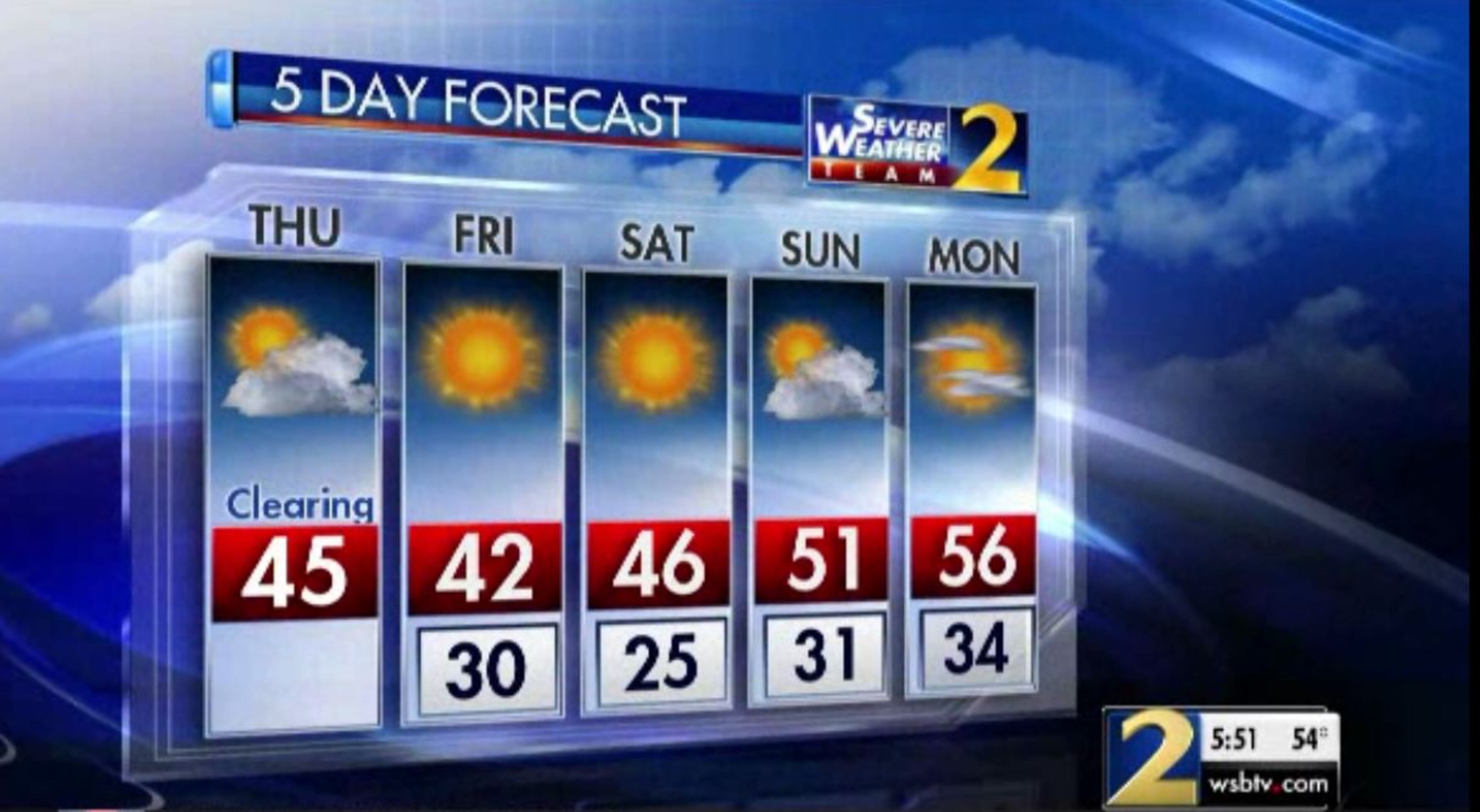
Thursday: High: 45
Thursday night: Low: 30
Friday: High: 43
» For a detailed forecast, visit The Atlanta Journal-Constitution weather page.
It has been a roller-coaster ride for Atlanta temperatures Thursday.
Atlantans woke up to the warmest weather of the day before it cooled off into the 30s. Then some places got brief flurries and drizzle. And now it has warmed into the low 40s.
Thursday night will shift again, dropping below freezing in many places, so the ride hasn’t finished yet, Channel 2 Action News reported.
Meanwhile, traffic is starting to mount across Atlanta as the evening commute hits full swing, according to the WSB 24-hour Traffic Center.
The heaviest delays are in Gwinnett County, where a wreck has three left lanes of I-85 North at Ga. 317 blocked, according to the Traffic Center. Delays span back to Sugarloaf Parkway.
#TRAVELADVISORY Gwinnett Co: Crash...I-85/nb at Hwy 317 (Exit 111). 3 left lanes blocked. Heavy delays growing back to Sugarloaf Pkwy. #ATLtraffic https://t.co/j2xHL1ZFrc
— AJC WSB Traffic (@ajcwsbtraffic) January 24, 2019
Downtown Super Bowl road closures continue.
Martin Luther King Jr. Drive is closed between Northside Drive and Centennial Olympic Park Drive until Feb. 7. Baker Street between Centennial Olympic Park Drive and Luckie Street is closed until Feb. 8. Mitchell Street between Martin Luther King Jr. Drive and Elliot Street, and Mangum Street between Markham and Foundry streets will also be closed until Feb. 7.
On Wednesday, crews closed off Andrew Young International Boulevard between Marietta Street and Centennial Olympic Park Drive. It will remain closed until Feb. 7.
MORE: Super Bowl 53: Some road closures already in place, more to come
It’s not preparations for the NFL championship game but construction that is causing some delays on Peachtree Street through Midtown. The project blocks all but one southbound left lane, according to the Traffic Center.
Fulton Co.; Construction: Peachtree St/sb at 26th St.; only the left lane is open; delays; https://t.co/MhPvicYKPN; #ATLTraffic pic.twitter.com/NxywED7goo
— AJC WSB Traffic (@ajcwsbtraffic) January 24, 2019
People in Cobb, Paulding, Douglas and Fulton counties might’ve seen some snowflakes late Thursday morning as the result of a cold front moving into Georgia, Channel 2 meteorologist Brad Nitz said.
The North Georgia mountains also saw snowfall, but the bump up in temperatures kept any snow from accumulating, Nitz said.
Flurries, mixing with drizzle in spots continues across parts of metro Atlanta now. pic.twitter.com/b9iu8yxz7W
— Brad Nitz (@BradNitzWSB) January 24, 2019
The moisture is left over from a cold front that brought heavy rain to North Georgia on Wednesday, causing minor flooding and taking down trees. Wet pavement during the morning drive likely contributed to several crashes, according to the Traffic Center.
The National Weather Service has issued flood warnings for several area rivers and creeks, including the Flint River near Lovejoy and Big Creek near Alpharetta. Minor flooding is already occurring in those areas and is forecast to continue, according to the Weather Service.
In northwest Atlanta, a downed tree at Howell Mill and Margaret Mitchell roads was blocking the roadway Thursday morning.

It’s currently 43 degrees. That’s a marked change from Wednesday, which saw an afternoon high of 67.
After highs near 70 yesterday -- what a change today! The colder air is here through the weekend...
— Brian Monahan, WSB (@BMonahanWSB) January 24, 2019
Tracking a couple systems, too -- one could bring flurries/rain showers (but very spotty) Sunday night... another one to more closely watch Tues/Wed.
On Friday morning, Atlanta is expected to wake up to 30-degree temperatures, and Minton said it will be even colder Saturday morning with a projected low of 25 degrees. Temps should not get out of the 40s on either day, and dry weather continues through this weekend, according to the latest forecast.
Considering Wednesday’s high in the upper 60s, that’s a more than 40-degree drop in temperatures by the weekend.
“We'll gradually work our way to the 50s early next week,” she said.
» For updated traffic information, listen to News 95.5 and AM 750 WSB and follow @ajcwsbtraffic on Twitter.
» Download The Atlanta Journal-Constitution app for weather alerts on-the-go.
About the Authors


Zachary Hansen, a Georgia native, covers economic development and commercial real estate for the AJC. He's been with the newspaper since 2018 and enjoys diving into complex stories that affect people's lives.