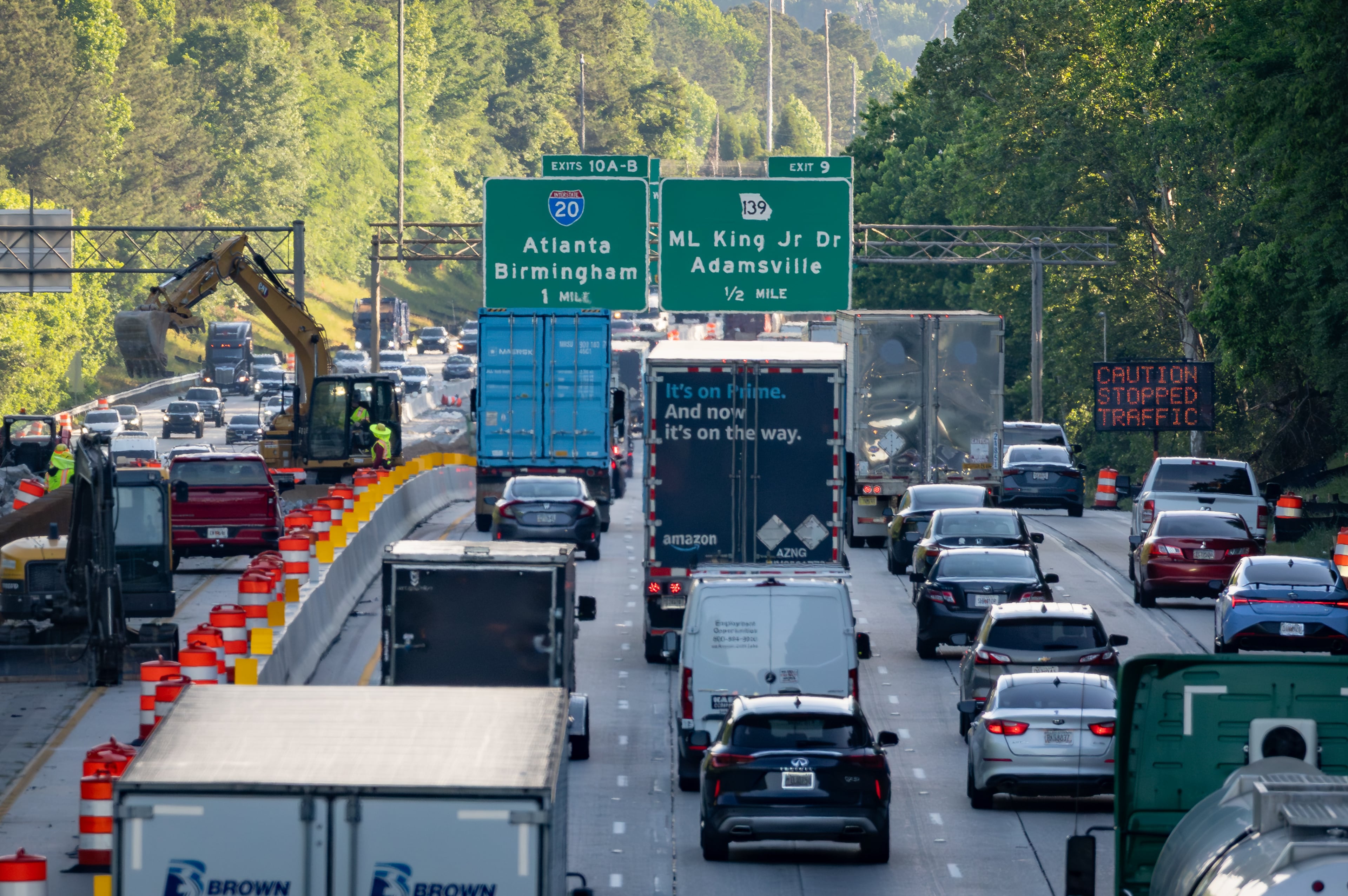
WEATHER-TRAFFIC UPDATE: Evening commute congestion increases on Atlanta’s interstates
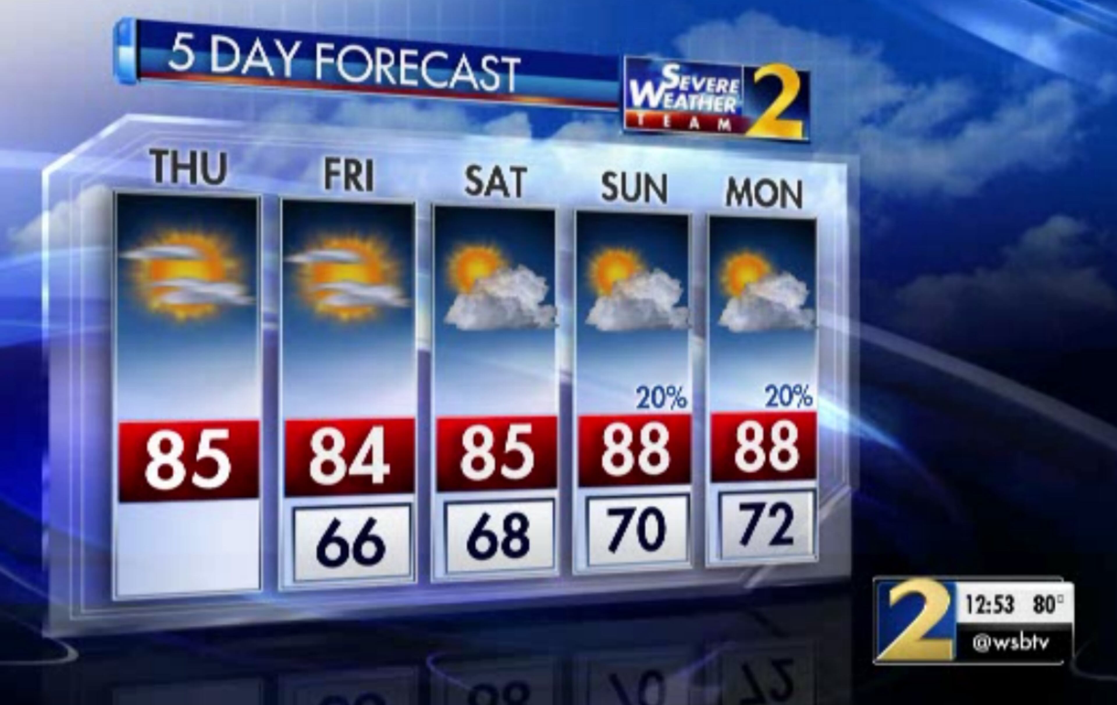
ATLANTA FORECAST
Thursday: High: 85
Thursday night: Low: 66
Friday: High: 84
» For a detailed forecast, visit The Atlanta Journal-Constitution weather page.
Atlanta drivers' typical dose of evening commute congestion has started, according to the WSB 24-hour Traffic Center.

This comes after several hours of delays, jams and bumper-to-bumper traffic this morning. An early Thursday morning injury crash on Ga. 400 North single-handedly gridlocked traffic on Ga. 400, I-85 and the entire Top End Perimeter, according to Traffic Center.
RELATED: Ga. 400 North reopens after crash, fuel spill
All southbound lanes of Peachtree Street in downtown Atlanta will be blocked at times Thursday for construction, and delays are expected to be heavy, according to the Traffic Center. Take Northside Drive as an alternate route.
TRAVEL ADVISORY: Fulton Co.: Construction: Peachtree St./sb at 26th St.; only a left lane is open; delays; use Northside Dr.; https://t.co/kTgeaYu0Zi; #ATLTraffic pic.twitter.com/o30MEYRHS2
— Triple Team Traffic (@WSBTraffic) August 23, 2018
Thursday will see plenty of sunshine and lower humidity, and no weather systems are expected to pass through, according to Channel 2 Action News. But that’s just the warm up for Friday, when humidity should drop even lower and temperatures are projected to fall a few more degrees.
Beautiful afternoons and cool-ish nights with low humidity the next few days. NE Georgia will drop into the 50s again by morning. pic.twitter.com/tx9QOlql4g
— Brad Nitz (@BradNitzWSB) August 23, 2018
It’s currently 85 degrees in metro Atlanta.
“You noticed that the humidity is coming down?” Channel 2 meteorologist Karen Minton asked. “Well, it’s coming down even more today. We’re going to wake up to some delightful weather (Friday) morning.”
Drier air is moving into Georgia this morning. Even drier air arrives Friday. Dew points are in the mid 60s this morning making the air feel much drier. Tomorrow morning the dew points will drop to the upper 50s. Cooler dew point temps = lower humidity. pic.twitter.com/vBt5RQb2fX
— Karen Minton (@KarenMintonWSB) August 23, 2018
The welcome break from the summertime heat and daily storms is due to a cold front now sitting over Florida. While high pressure is the dominant feature today, Minton said the moisture will eventually return to North Georgia.
“What will happen in the next 24 hours is some moisture shift will start happening along coastal Georgia,” she said. “We’ll start to see those winds shifting. That’s going to push more moisture to the area and that dry air will be squeezed toward the north.”
For now, there’s no rain in the forecast through the weekend, and the temperatures shouldn’t escape the low 80s, according to the latest forecast from Channel 2. In some parts of the North Georgia mountains, the temperature isn’t expected to reach 80 degrees Thursday.
Not overly wet or dry....that is the trend through the first week of September. Expecting near normal rain chances. It is expected to be warmer than normal. pic.twitter.com/YT4cSujzPP
— Karen Minton (@KarenMintonWSB) August 23, 2018
» For updated traffic information, listen to News 95.5 and AM 750 WSB and follow @ajcwsbtraffic on Twitter.
» Download The Atlanta Journal-Constitution app for weather alerts on-the-go.
About the Authors

Zachary Hansen, a Georgia native, covers economic development and commercial real estate for the AJC. He's been with the newspaper since 2018 and enjoys diving into complex stories that affect people's lives.