WEATHER-TRAFFIC UPDATE: Construction, crashes contribute to cluttered roads
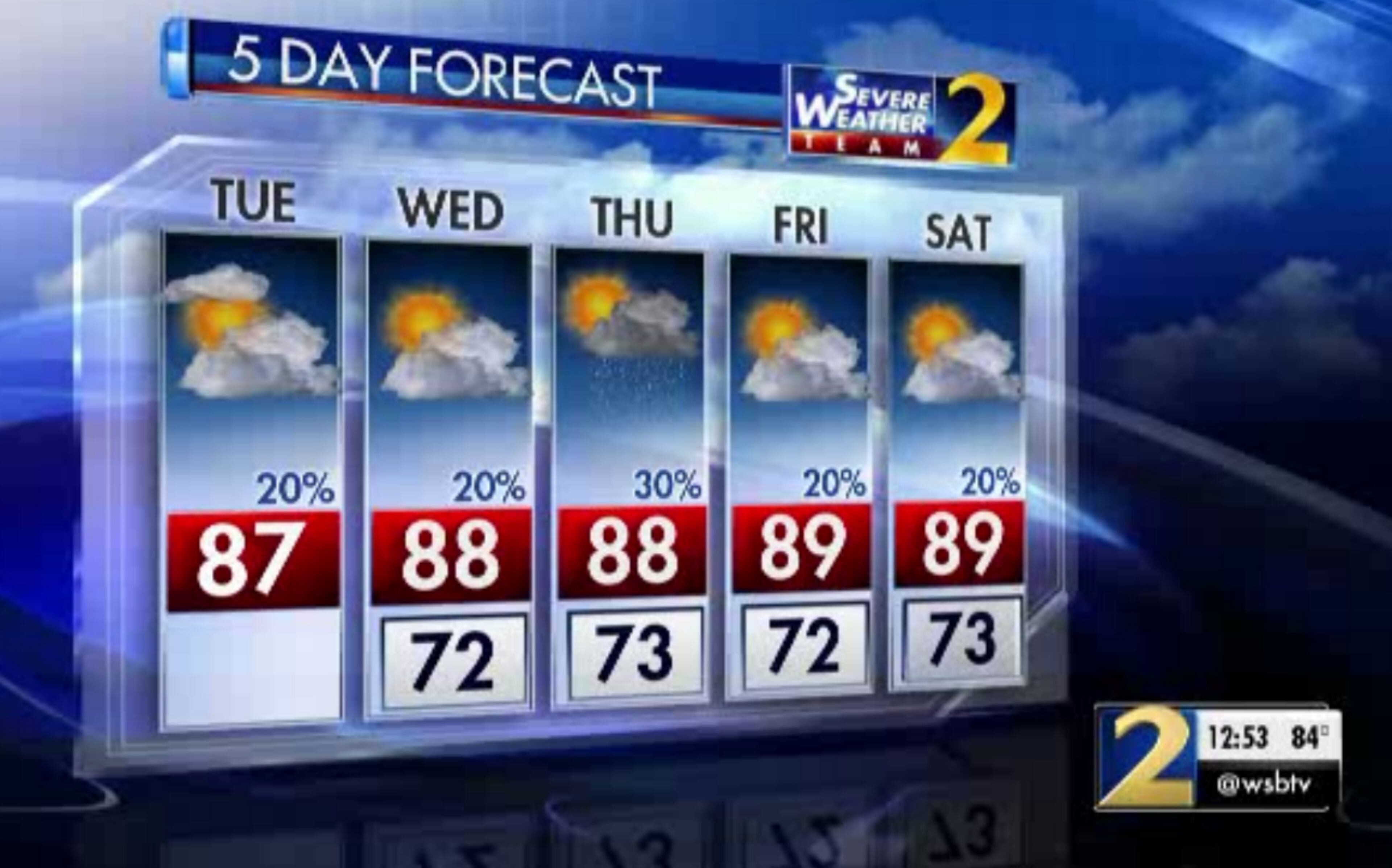
ATLANTA FORECAST
Tuesday: High: 87
Tuesday night: Low: 72
Wednesday: High: 88
» For a detailed forecast, visit The Atlanta Journal-Constitution weather page.
Various construction projects and crashes are beginning to clutter the evening commute as it begins to ramp up, according to the WSB 24-hour Traffic Center.
There are already several trouble spots to avoid.
A car fire in Fulton County has two lanes of I-285 shut down, causing delays, according to the Traffic Center.
Fulton Co: I-285/sb (outer loop) before Hollowell Pkwy (exit 12); car fire blocking 2 left lanes; delays https://t.co/2hvjWkI3bV #ATLtraffic pic.twitter.com/ZGVo2AsEy6
— AJC WSB Traffic (@ajcwsbtraffic) September 4, 2018
Those traveling on I-85 South in Jackson County are dealing with a major headache. Near the Winder Highway exit, all southbound lanes are blocked by a rollover crash, and traffic is being diverted at Ga. 129, the Traffic Center reported.
#REDALERT Jackson Co: I-85/sb before Hwy 53/Winder Hwy (exit 129); all lanes blocked by a rollover crash; traffic being diverted off at exit 137 Hwy 129, or you can use Hwy 124 as an alternate https://t.co/2hvjWkI3bV #ATLtraffic pic.twitter.com/LbwQQQXM15
— AJC WSB Traffic (@ajcwsbtraffic) September 4, 2018
Construction continues on Peachtree Road between Deering Road and 25th Street, shutting down some northbound lanes at times. Delays should pick up when the evening commute hits full steam.
Also tonight, the Atlanta Dream take on the Washington Mystics in Game 5 of the WNBA conference finals at 8 p.m. at Georgia Tech’s McCamish Pavilion. Traffic nearby could increase near tipoff.
RELATED: WNBA semifinal returns to Atlanta after Mystics rout Dream in Game 4
Get ready for Game 5️⃣ TONIGHT with some Dream highlights over the first 4️⃣ games. #DefendTheATL pic.twitter.com/bpeeN8VtHO
— Atlanta Dream (@AtlantaDream) September 4, 2018
Despite a strengthening tropical storm churning toward the Gulf Coast, North Georgia is expected to stay hot and mostly dry over the next several days.
An area of high pressure is keeping the tropical moisture at bay, according to Channel 2 Action News meteorologist Brian Monahan. When Tropical Storm Gordon makes landfall later Tuesday, Monahan said it likely won’t have much effect on Georgia weather.
GORDON UPDATE: Tropical Storm Gordon's pressure is down a bit at 11am, but wind remains at 65 mph. Bands of heavy rain are moving toward the FL panhandle now as the storm generally moves toward Mississippi and SE LA.
— Brian Monahan, WSB (@BMonahanWSB) September 4, 2018
I'm updating the path at noon on Ch 2. pic.twitter.com/w4gjZILkWY
“Some of these clouds are actually spilling northward across North Georgia, but all the rain, all the storms, all the rough weather with this system is going to stay well to our south,” he said.
The storm is tracking westward and away from the state. It could reach hurricane strength before it reaches southeast Louisiana and Mississippi, according to Channel 2. Monahan said it likely won’t curve back toward Georgia, unlike Tropical Storm Irma this time last year.
Latest forecast track brings #Gordon ashore over SE LA/MS/AL as a Category 1 hurricane. We'll have a new advisory before 5am this morning. @wsbtv pic.twitter.com/mrMChp9dlR
— Brian Monahan, WSB (@BMonahanWSB) September 4, 2018
That means the heat and pattern of limited rain will carry over from the holiday weekend and extend through the work week, he said.
Temperatures have reached the mid-80s on this cloudy, dry afternoon, and the predicted high is 87 degrees.
“Temperatures feeling more like midsummer than late summer this afternoon across North Georgia,” Monahan said. “We're headed for the upper 80s to around 90 degrees, and not a whole lot of rain today, just an isolated storm chance will take us on through the afternoon.”
Tracking temps in the 70s and low 80s now across north GA... a little cooler today with more clouds. @wsbtv
— Brian Monahan, WSB (@BMonahanWSB) September 4, 2018
There is a 20 percent chance of showers developing in the late afternoon, “but they are going to be few and far between,” he said.
Most metro Atlanta neighborhoods should stay dry.
RAINFALL OUTLOOK THIS WEEK: Good morning! We're still looking at low rain chances most of the week across N GA, with heavy rain staying well to our south and west in association with Gordon.
— Brian Monahan, WSB (@BMonahanWSB) September 4, 2018
I'll have the latest on Gordon now through 7am on Ch. 2! pic.twitter.com/70ENIl6opw
The drier weather should allow the Georgia Department of Transportation to work on the reconstructed Mount Vernon Highway bridge as scheduled this week.
GDOT will temporarily close multiple lanes on Ga. 400 South overnight Tuesday to Friday, according to a news release. Closures will be Tuesday and Wednesday from 10 p.m. to 5 a.m., and Wednesday through Friday from 9 p.m. to 5 a.m. Two right lanes and two left lanes will close alternately on Ga. 400 southbound at Mount Vernon Highway.
But no rain means no relief for allergy sufferers. The weed pollen season is here and ragweed, pigweed and dog fennel pollen counts were in the moderate range Tuesday morning, according to Channel 2.
Are your eyes starting to water and are you getting congested again? I am! Guess why? Weed pollen season is here -- in the moderate range this morning. #pollen @wsbtv pic.twitter.com/CpefljXado
— Brian Monahan, WSB (@BMonahanWSB) September 4, 2018
» For updated traffic information, listen to News 95.5 and AM 750 WSB and follow @ajcwsbtraffic on Twitter.
» Download The Atlanta Journal-Constitution app for weather alerts on-the-go.