WEATHER-TRAFFIC UPDATE: Below freezing morning builds to sunny, albeit cold, afternoon
ATLANTA FORECAST
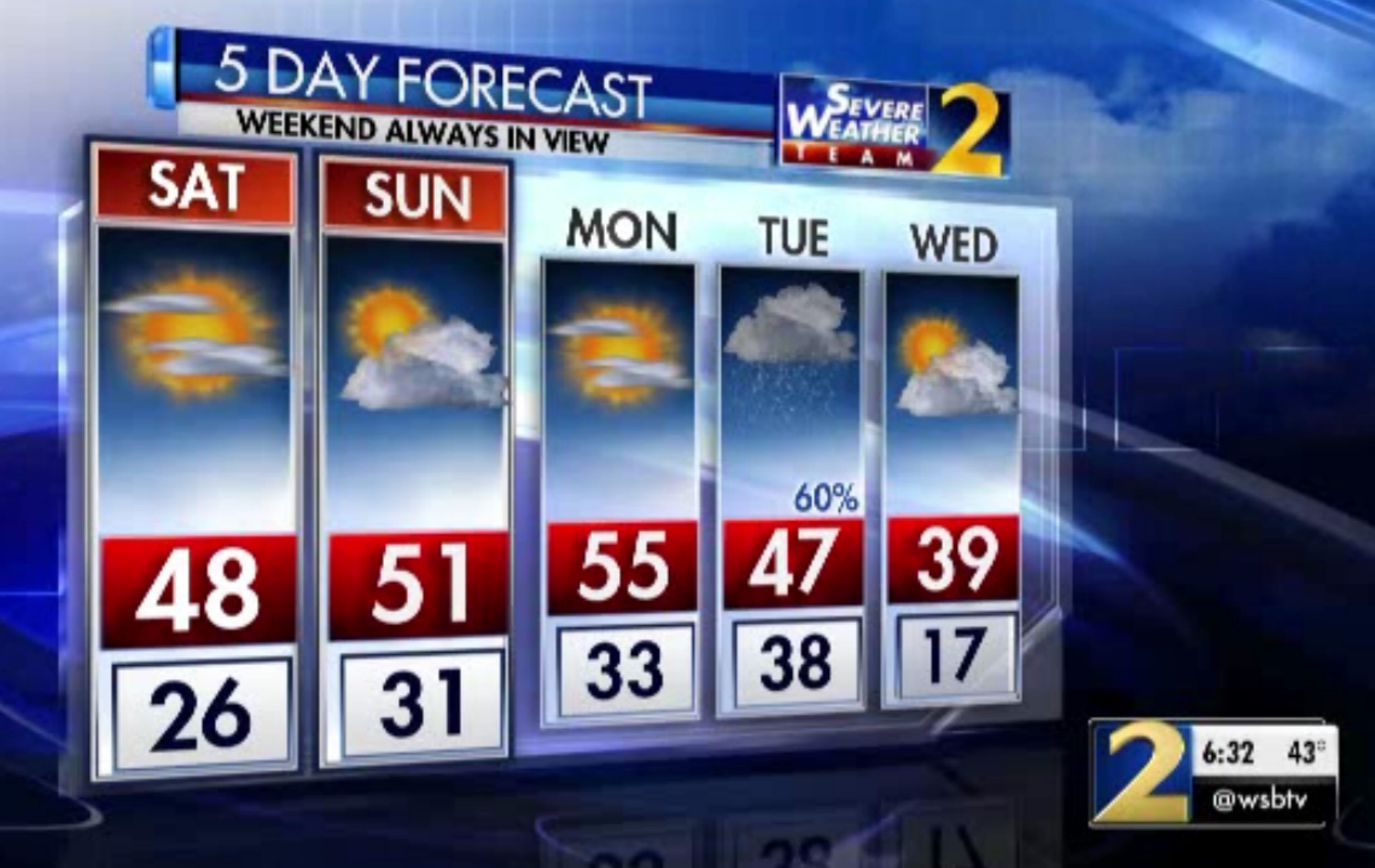
Saturday: High: 50
Saturday night: Low: 30
Sunday: High: 52
» For a detailed forecast, visit The Atlanta Journal-Constitution weather page.
A little relief from the cold will come this weekend — emphasis on little.
Saturday morning started below freezing across North Georgia, but warmed up to about 50 in the afternoon, which is only a few degrees below average for this time of year.
“It’ll be a very cold start to your Saturday, but with the air being dry with plenty of sunshine in the afternoon, it’ll be just a touch warmer than (Friday),” Channel 2 Action News chief meteorologist Glenn Burns said.
Great looking Saturday! Don't let the sunshine fool you especially getting out early this morning, temps are in the 20s. Later today will hit 50° in #Atlanta pic.twitter.com/zibz2ptGs9
— Eboni Deon, WSB (@ebonideonWSB) January 26, 2019
There were no major crashes muddying the Saturday morning drive on Atlanta’s interstates, but road work on I-285 southbound near Flat Shoals Road is creating delays for a stretch of the inner loop, according to the WSB 24-hour Traffic Center.
DeKalb Co: I-285/sb (inner loop) from I-20 down to Flat Shoals Rd (exit 48); road work blocking 2 left lanes; expect delays https://t.co/KslBQmUsyy #ATLTraffic pic.twitter.com/zH5MGoiUhV
— Triple Team Traffic (@WSBTraffic) January 26, 2019
With no rain in the forecast, Saturday and Sunday should make for a good winter weekend outdoors. Burns said to cherish it, because “oh, that is going to change.”
He said one of the coldest systems of air he’s seen in a long time is making its way into the Midwest and Eastern United States. By Tuesday morning, it should enter North Georgia, bringing some frosty weather with it.
He called the system an Alberta clipper, which gets its name from the Canadian province. Few things are more Canadian than lots of snowfall, so you can probably see what this system is bringing with it.
Tuesday's cold front will bring rain potentially changing over to snow in much of our area. The amounts and locations are what we'll be nailing down over the next couple days.
— Brad Nitz (@BradNitzWSB) January 25, 2019
I'm tracking this arctic cold front live on @wsbtv now. pic.twitter.com/sNUwbYRlJz
“An Alberta clipper is an extremely fast-moving storm ... that’s going to drag the cold front across Northern Georgia,” Burns said. “It’s going to be knocking on our door around 7 a.m. Tuesday and rapidly expand (toward Atlanta).”
Following the storm is a rush of very cold air and rain, meaning there’s a very narrow window where snow will likely fall across most of metro Atlanta.

Burns said it won’t be a long window, so as snow accumulates, it should be on the very light side. However, it’s important to keep an eye on the forecast as Tuesday approaches, since the predictions will become more precise and specific about when and how much snow may fall.
In the meantime, downtown travelers need to keep in mind that many roads are closed in preparation for the Super Bowl. For a full list of road closures, click here.
» For updated traffic information, listen to News 95.5 and AM 750 WSB and follow @ajcwsbtraffic on Twitter.
» Download The Atlanta Journal-Constitution app for weather alerts on-the-go.
About the Authors

Zachary Hansen, a Georgia native, covers economic development and commercial real estate for the AJC. He's been with the newspaper since 2018 and enjoys diving into complex stories that affect people's lives.

J.D. is a local news reporter covering intown Atlanta and Atlanta City Hall for The Atlanta Journal-Constitution.

