WEATHER-TRAFFIC UPDATE: Light volume at lunch ahead of Christmas Eve congestion
ATLANTA FORECAST
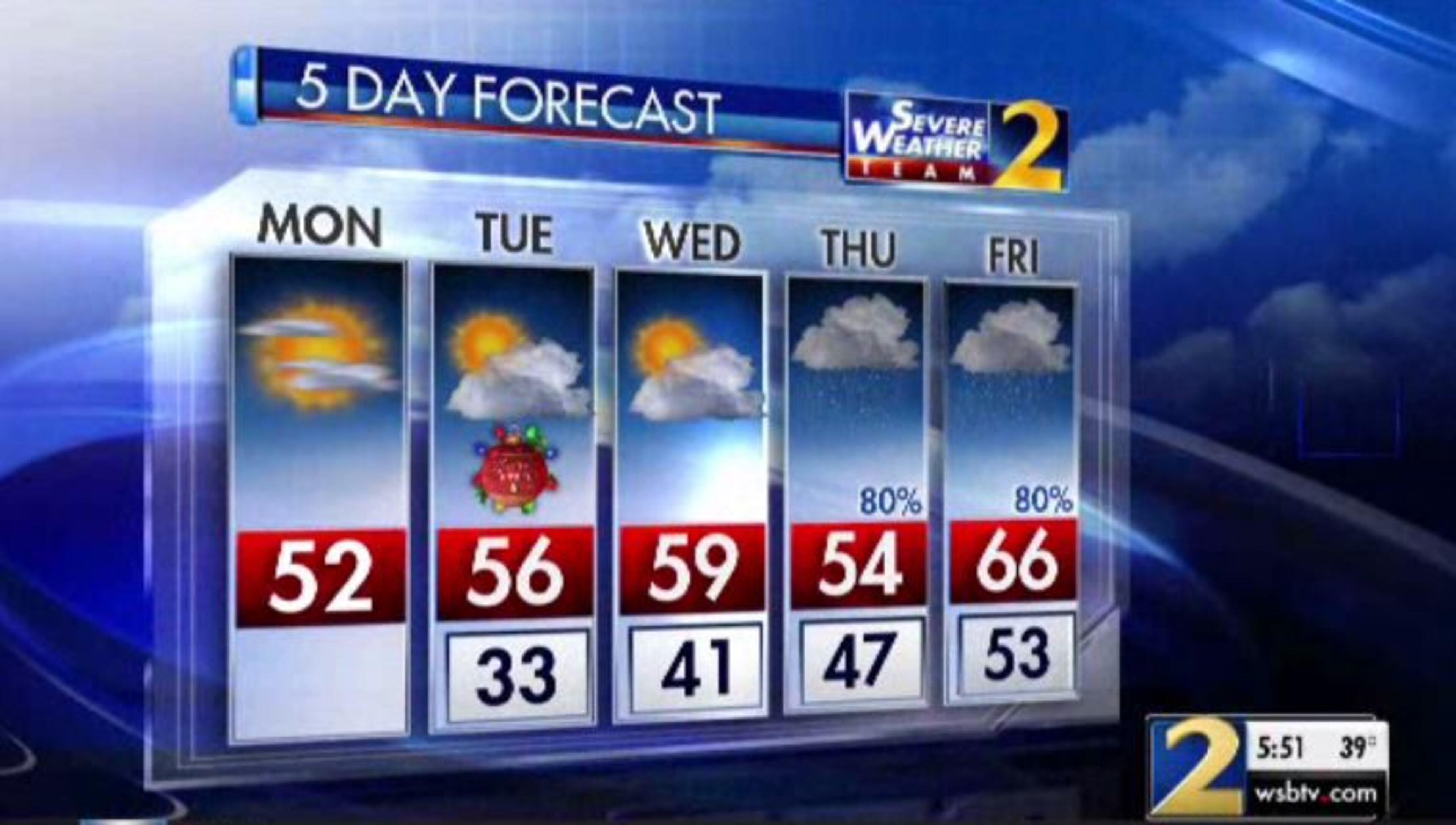
Monday: High: 52
Monday night: Low: 33
Tuesday: High: 56
» For a detailed forecast, visit The Atlanta Journal-Constitution weather page.
Those heading to lunch on Monday may have to battle holiday shopping traffic on surface streets, but metro Atlanta interstates are wide open.
Volume was lighter than normal for the morning drive and it appears the trend will continue through lunchtime, according to the WSB 24-hour Traffic Center.
That’s not surprising, considering most travelers have already made it to their Christmas destinations. Although, according to data compiled by the traffic app Waze, congestion could build later in the day Monday.
RELATED: You've been warned: The worst times to drive in Atlanta this Christmas
Those headed north will be able to make use of the I-75 express lanes through Cobb and Cherokee counties. The lanes will stay northbound Monday and Tuesday and reverse Tuesday at 11 p.m., after most Christmas festivities have concluded.
...Can only travel northbound through Cobb and Cherokee Counties in the #NWExpressLanes today and tomorrow. #ATLtraffic https://t.co/eSf5ZtpX7X
— Ashley Frasca (@AshleyFrascaWSB) December 24, 2018
Temperatures in Atlanta have warmed into the 40s, a marked difference after Monday morning’s sub-freezing wind chills. It is expected to remain dry and mostly sunny all day, according to Channel 2 Action News meteorologist Katie Walls, perfect travel conditions for those hitting the roads ahead of the big day.
“(A) breeze will continue out of the northwest, driving in that drier air, and you’ll certainly be noticing that drier air as well,” she said. “It’s quick to cool down, but it’s also quick to warm up, so I am anticipating those temperatures this afternoon to be climbing into the lower 50s.”
That’s right on target for this time of year. According to Channel 2, the average high for the week of Christmas is 52 degrees. On Sunday, Atlanta hit 62 degrees, but Monday should be a little cooler on the other side of a cold front, Walls said.
Average high is in the low 50s -- that's exactly where we'll be today... and pretty close to it tomorrow, too.
— Brian Monahan, WSB (@BMonahanWSB) December 24, 2018
It's a pretty "average" Christmas -- no white Christmas, and no shorts and flip flops for Santa. :)
The projected high Monday is a “seasonably mild” 52 degrees for Atlanta, she said.
The rest of the Southeast will also be dry and partly cloudy for the day before Christmas, according to Channel 2.
Great travel day for the southeastern quadrant of the U.S. Weather-related issues aren't expected for ATL. pic.twitter.com/bbqSESS6wc
— Katie Walls (@KatieWallsWSB) December 24, 2018
“Whether you're heading from Little Rock, to Charleston, South Carolina, it’s looking lovely, especially as we head down toward Florida,” Walls said.
Overnight and into Tuesday morning, when Santa takes flight, more clear, cold conditions are expected across North Georgia, according to Channel 2.
And he's going to love flying through the clear sky tonight over N GA! https://t.co/zmu6R8tlHt
— Katie Walls (@KatieWallsWSB) December 24, 2018
“Tomorrow morning, it’s going to be chilly for your Christmas Day,” Walls said. “Notice temperatures for most of us starting off near freezing or below freezing, so please plan accordingly. The next couple of days will certainly will be on the cool side.”
A chilly start today, but high temperatures will climb into the lower 50s. Santa will love flying through & over N GA tonight under a mostly clear sky! A few more clouds are forecast for your Tuesday afternoon but we'll maintain that dry radar pic.twitter.com/3OQrePPt0W
— Katie Walls (@KatieWallsWSB) December 24, 2018
Just a few clouds are expected in the afternoon Tuesday with temperatures warming into the middle 50s, according to Channel 2. The radar stays quiet through Wednesday, but on Thursday widespread rain should move in, Walls said.
Lots and lots of it.
Significant rain is headed our way late week. While I'm not concerned about severe weather, I am monitoring the flooding threat considering how saturated the ground it. 2018 is currently ranked the 8th wettest for ATL. 2018 will likely end up in the Top 5. pic.twitter.com/SOUAGWBGxR
— Katie Walls (@KatieWallsWSB) December 24, 2018
“Ramping up those rain chances as we head into your Thursday and Friday — 80 percent opportunity for rain,” Walls said. “We are talking about 3 to 5 inches of rainfall between Thursday and Sunday. Unfortunately, flooding is a risk but at this point not seeing a risk for severe storms any of those days.”
» For updated traffic information, listen to News 95.5 and AM 750 WSB and follow @ajcwsbtraffic on Twitter.
» Download The Atlanta Journal-Constitution app for weather alerts on-the-go.
About the Author


