LIVE UPDATES: ‘Serious flooding’ ongoing across metro Atlanta
ATLANTA FORECAST
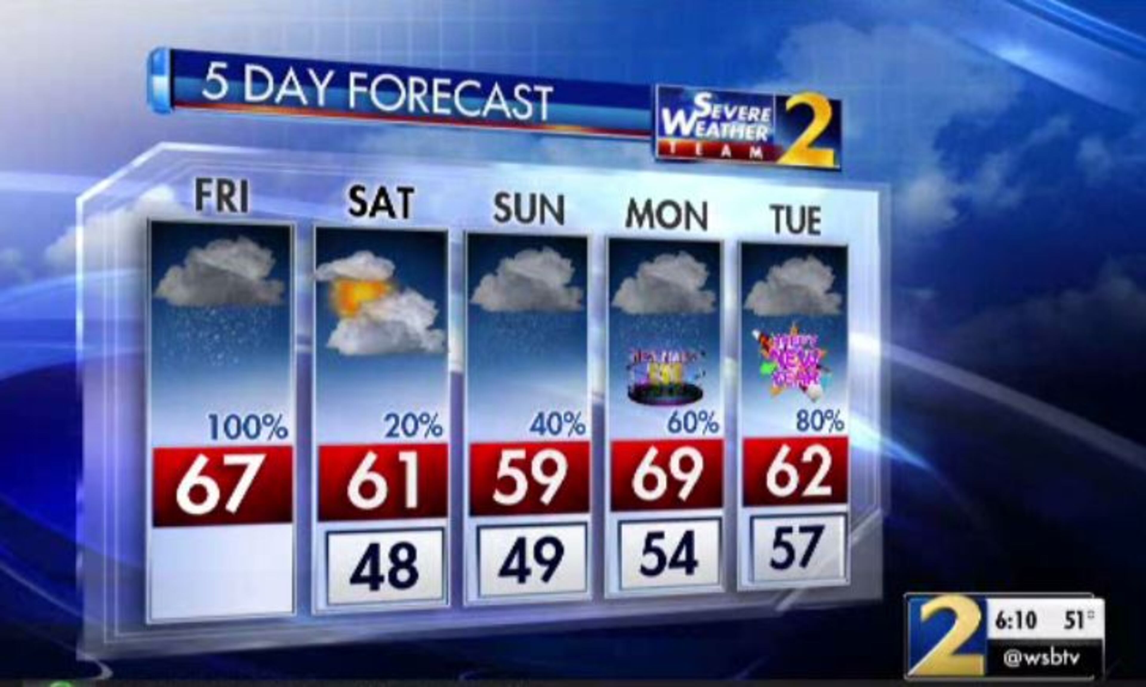
Friday: High: 67
Friday night: Low: 48
Saturday: High: 61
» For a detailed forecast, visit The Atlanta Journal-Constitution weather page.
[UPDATE 11:09 a.m.]: The heaviest of the rain has moved east of metro Atlanta, but flood warnings continue for a number of areas.
Channel 2 Action News meteorologist Eboni Deon said rainfall totals top 4 inches in Alpharetta, Newnan and Helen. Dunwoody picked up nearly 5 inches.
The heaviest of the rain has moved east of the metro but flood warnings continue for a number of areas. Rainfall totals as of 9:30 AM top 4" in Alpharetta, Newnan & Helen. Dunwoody has picked up nearly 5". Reports of roads closed in Roswell (Azalea Rd.) due to flooding. pic.twitter.com/mHRjgCwr2v
— Eboni Deon, WSB (@ebonideonWSB) December 28, 2018
[UPDATE 10:28 a.m.]: Parts of metro Atlanta have seen more than 4 inches of rainfall in the last 24 hours, leading to numerous flood warnings and road closures.
The Chattahoochee River is rising, prompting officials to close Azalea Road between Ga. 9 and Willeo Road.
RELATED: Trees down, streets flooded in Cobb amid heavy rain
According to Channel 2 Action News, this first round of rain will gradually clear in the afternoon.
“I’m only expecting a few showers on radar from 4-6 p.m.,” Channel 2 meteorologist Katie Walls said. “... This evening into tonight will be mostly cloudy but mainly dry.”
Round two is expected to move in overnight Saturday but will be weak and produce minimal rainfall, she said.
Round three could impact the Peach Drop and other New Year’s Eve events, according to Channel 2.
An additional 2 to 3 inches of rain could fall with rounds two and three, Walls said.
[UPDATE 10:10 a.m]: Serious flooding is ongoing across metro Atlanta, Channel 2 Action News meteorologist Katie Walls said.
“I’m seeing reports in Roswell and Sandy Springs,” Walls said. “... Remember to NEVER cross a barricade or a flooded roadway.”
Serious flooding is ongoing across the Metro. I'm seeing reports in Roswell and Sandy Springs. Road closures are coming in: Black Water Trl at Harbor Dr and Roswell Rd at Sandy Springs Cir are closed due to flooding. Remember to NEVER cross a barricade or a flooded roadway. pic.twitter.com/WoI6QEy6gW
— Katie Walls (@KatieWallsWSB) December 28, 2018
Black Water Trail at Harbor Drive and Roswell Road at Sandy Springs Circle are closed due to flooding, according to Channel 2.
RELATED: Man rescued after high water trapped him in car in Atlanta
In Alpharetta, flooding has closed McGinnis Ferry Road between McFarland and Union Hill Roads.
ROAD CLOSURE ALERT: McGinnis Ferry Road is closed between McFarland and Union Hill Roads due to flooding. Please plan routes accordingly to avoid the area. pic.twitter.com/WjybEDW0ht
— City of Alpharetta (@alpharettagov) December 28, 2018
[UPDATE 9:50 a.m.]: Heavy rain continues to fall in metro Atlanta Friday morning, pushing 2018 into the third spot for wettest years on record. As of 9 a.m. Friday, 68.49 inches of rain have fallen in Atlanta this year, according to Channel 2.
That’s just 3 inches less than in 1948, the wettest year on record.
As of 9am (and the numbers are still climbing), 2018 is now ranked the 3rd WETTEST on record for Atlanta going back to 1879. pic.twitter.com/cMI46sjzMI
— Katie Walls (@KatieWallsWSB) December 28, 2018
Intense rain is now moving through Hartsfield-Jackson International Airport.
Intense rain is moving through @ATLairport right now. The FAA, however, is reporting gate hold and taxi delays lasting 15 minutes or less. #Stormwatchon2 pic.twitter.com/ij7DPLN5cl
— Katie Walls (@KatieWallsWSB) December 28, 2018
The heaviest downpours are east of I-85, Walls said.
“Flash flooding will remain a concern through the day, but I am expecting gradual improvement as we head through this afternoon,” she said.
The heaviest downpours in orange and red are now east of I-85. Flash flooding will remain a concern through the day, but I am expecting gradual improvement as we head through this afternoon. pic.twitter.com/2bAxeQNjAh
— Katie Walls (@KatieWallsWSB) December 28, 2018
[UPDATE 9:40 a.m.]: More metro Atlanta rivers, streams and creeks have reached flood stage and are overflowing their banks Friday morning, according the the National Weather Service. Flood warnings have been issued for the Chattahoochee River near Roswell in Fulton, Suwanee Creek in Gwinnett, Shoal Creek in Coweta, Dick Creek in Forsyth, and for Sweetwater Creek affecting Cobb, Douglas and Gwinnett counties.
Flood warnings have also been issued for parts of Fulton, Clayton and Douglas counties due to flooded roads.
"Two to five inches of rain have fallen," the Weather Service said in an advisory. "The rain will continue to cause flooding, and several counties have reported roads closed especially in low-lying, flood prone areas."
Numerous Flood and Flash Flood Warnings are in effect as more rain moves through the Metro. Rain is heavy at times and will remain a concern into the early afternoon. #gawx #StormWatchon2 pic.twitter.com/438FpWCRfW
— Katie Walls (@KatieWallsWSB) December 28, 2018
[UPDATE 9 a.m.]: The National Weather Service has issued a flash flood warning until 2:30 p.m. for Towns, Lumpkin and White counties and parts of Dawson, Hall and Union counties.
"Flash flooding is expected to begin shortly, if not already occurring," the Weather Service said in an advisory. "Also, White County emergency management has reported several county roads closed due to flooding."
FLASH FLOOD WARNING in effect for Dawson, Hall, Lumpkin, Towns, Union and White counties until 2:30PM. Persistent rainfall in NE GA this morning has led to flooding. An additional 1-3" are possible in the next 6 hours. #StormWatchon2 pic.twitter.com/sSOXg6DZgr
— Katie Walls (@KatieWallsWSB) December 28, 2018
ORIGINAL STORY: Rain, rain and more rain.
The forecast is looking very wet over the next several days as North Georgia gets round after round of rainfall, according to Channel 2 Action News. Round one has already brought more than 3 inches of rain at Hartsfield-Jackson International Airport since Thursday afternoon, and Channel 2 meteorologist Brad Nitz expects an additional 1 to 2 inches to fall Friday.
8am update: 3.13" rainfall has been measured in Atlanta (at @ATLairport ) since the rain began yesterday afternoon.
— Brad Nitz (@BradNitzWSB) December 28, 2018
An additional 1-2" rainfall is possible today. The flood threat increase through the morning. Flash Flood Watch is in effect today.
Through the next five to seven days, Channel 2 meteorologist Katie Walls said she is “looking at rainfall totals upwards of 6 inches, so I anticipate the flooding to remain a concern.”
This year was sitting at the eighth-wettest on record for Atlanta at the beginning of the week, but the rainfall Thursday and Friday morning has bumped 2018 through the rankings. It is now ranked as the fourth-wettest year on record, and Walls said it could be close the top spot by Dec. 31.
The record was set at 71.45 inches in 1948, and Atlanta was at 68.29 inches after 8 a.m. Friday.
Update: 68.29” now for 2018... less than a tenth of an inch from moving into 3rd wettest on record! https://t.co/XZFVornT5g
— Brian Monahan, WSB (@BMonahanWSB) December 28, 2018
All of North Georgia is under a flash flood watch until 7 a.m. Saturday, and flood warnings have been issued for several rivers, creeks and streams around metro Atlanta. The National Weather Service issued a new flood warning Friday morning for North Fork Peachtree Creek, affecting DeKalb and Fulton counties.
Flood warning for Peachtree Creek. Flooding expected on roads and yards in this area. pic.twitter.com/UxkuoqJQ1z
— Brad Nitz (@BradNitzWSB) December 28, 2018
All this rain is also causing concern for ponding on the roads and downed trees, Walls said. Officials reported some roads in Sandy Springs in north Fulton County are closed due to flooding.
Riverside Drive at North Harbor, Riverside Drive south of Johnson Ferry Road and Roswell Road at Sandy Springs Circle are shut down, police said.
And authorities are monitoring Nancy Creek at Windsor Parkway.
“With additional rain in the forecast,” police said in a tweet, “we are preparing for flooding in low areas. Use caution if driving and don’t cross flooded roads.”
We are monitoring Nancy Creek at Windsor Parkway. With additional rain in the forecast we are preparing for flooding in low areas. Use caution if driving and don’t cross flooded roads. pic.twitter.com/WpNxQorlQk
— Sandy Springs Police (@SandySprings_PD) December 28, 2018
“On the plus side, strong severe weather is not in my forecast,” she said.
Rain fell for several hours overnight. While there is a break now, more showers are on the way from a system in Alabama, Walls said.
“What’s in Alabama, that’s going to be heading our direction really for the first half of that day,” she said. “Just because we (have) that little bit of a gap, don’t let your guard down yet because we have plenty of rainfall ahead of this next approaching cold front.”
Intense rain and storms are moving out of AL into NW and W GA. Gusty winds, heavy rainfall, frequent lightning are concerns this morning. FLASH FLOOD WATCH remains in effect through 7am Saturday. #StormWatchon2 pic.twitter.com/s5diR7mSzJ
— Katie Walls (@KatieWallsWSB) December 28, 2018
By 9 a.m., the next bands of rain should be moving across the border and into northwest Georgia, Walls said. At 11 a.m., it could be raining just about everywhere in North Georgia.
“Not looking good at all for any midday travel as we are expecting those areas of heavy rainfall, even some embedded thunderstorms a possibility,” she said.
The silver lining? By the afternoon, temperatures are projected to reach highs in the mid- to upper 60s, making conditions positively springlike for the end of December.
Well...temperatures today will be spring-like...BUT we'll be dealing with rain nearly all day with embedded storms. I'm timing when the rain clears late this evening NEXT pic.twitter.com/KumIL6l6rH
— Katie Walls (@KatieWallsWSB) December 28, 2018
And while more rain is highly likely over the next couple of days, Walls said, at least it won’t be constant.
“The rain chances today, you might have guessed it, they’re at 100 percent,” she said. “But I am expecting some improvements later in the day, so your afternoon and evening commute should be vastly different.”
The bulk of the rainfall is expected to clear North Georgia by 4 p.m. as a cold front slides into the state, bringing in drier air. The cloud cover should stick around, but Walls said the chance of rain goes down significantly for Saturday at 20 percent.
6PM Snapshot -- Round 1 DONE as the end of the rain pushes to our southeast. Clouds will stick around but we'll dry out this evening into Saturday. Live updates every ten minutes on Ch. 2 #gawx pic.twitter.com/uuPU856Zid
— Katie Walls (@KatieWallsWSB) December 28, 2018
“Clouds will basically not break at all tonight into tomorrow, but at least we will be heading into a bit of a break (in the showers), allow the ground to try to absorb some of this rainfall,” she said. “At this point it does look like your Friday night into most of the day on Saturday should be mainly dry.”
Round two, forecast to roll in at the end of the weekend, should not come on quite as strong, according to Channel 2. But Walls expects heavy rainfall Monday night to put a damper on your New Year’s Eve plans.
“The next big wave of rain, unfortunately, it’s arriving right in time for New Year’s Eve into New Year’s Day,” she said. “At this point, some of these heavier rain showers look to be moving in on the night of New Year’s Eve.”
The rain is doing nothing for Atlanta traffic Friday morning.
The crashes are happening, people. Rollover. Crash into a wall. We’re checking road conditions and the rain forecast every 10 mins on Channel 2 @wsbtv. @KatieWallsWSB @DaveHWSB @AshleyFrascaWSB pic.twitter.com/ZZWYIJgScC
— Linda Stouffer (@LindaWSB) December 28, 2018
While crashes have been numerous before daybreak, they have been clearing quickly, according to the WSB 24-hour Traffic Center. A crash on I-20 East past Boulevard in Fulton County was blocking all lanes of the interstate for a time, but it was cleared by 5:45 a.m. Delays remain through the area, the Traffic Center reported.
TRAVEL ADVISORY: Fulton Co.; Crash: I-20/eb past Boulevard; (exit 59A); now the left lanes are open; delays remain; https://t.co/MhPvicYKPN; #ATLtraffic pic.twitter.com/7i1XBTOqjX
— AJC WSB Traffic (@ajcwsbtraffic) December 28, 2018
Delays are are “pretty extensive” after a car rolled over on its roof on the northbound Downtown Connector at University Avenue, traffic reporter Ashley Frasca said. All lanes were blocked before the crash was cleared from the travel lanes at 6 a.m.
It could be a while before traffic recovers.
“Be patient traveling through downtown,” Frasca said.
TRAVEL ADVISORY: Downtown: Overturned Vehicle: I-75/85/nb at University Ave; (exit 244); several left lanes are blocked; use I-285; https://t.co/MhPvicYKPN; #ATLtraffic pic.twitter.com/FFIlCs0qVn
— AJC WSB Traffic (@ajcwsbtraffic) December 28, 2018
» For updated traffic information, listen to News 95.5 and AM 750 WSB and follow @ajcwsbtraffic on Twitter.
» Download The Atlanta Journal-Constitution app for weather alerts on-the-go.
About the Author