WEATHER-TRAFFIC UPDATE: Evening commute traffic lighter than usual; isolated showers in Atlanta
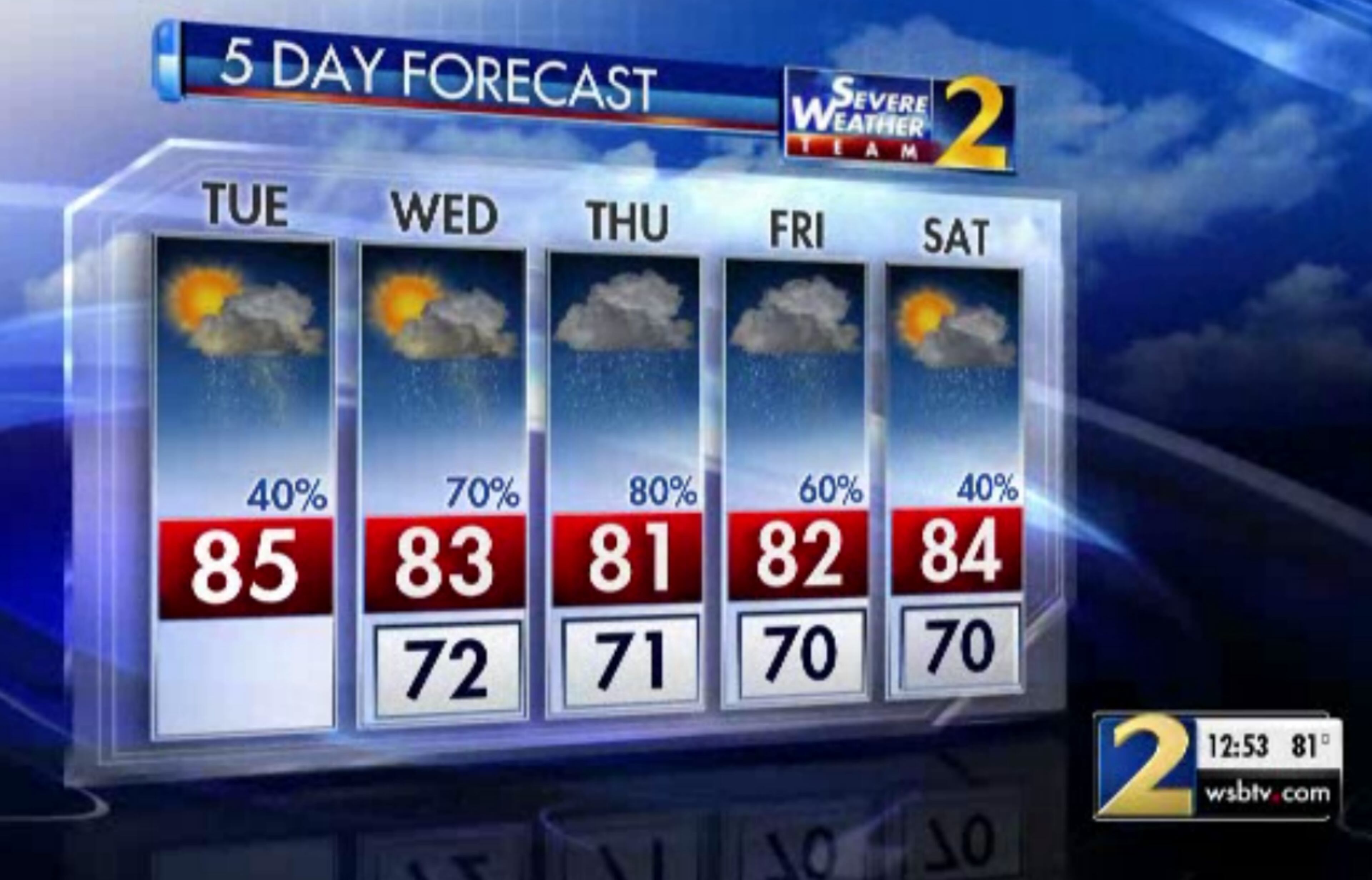
ATLANTA FORECAST
Tuesday: High: 85
Tuesday night: Low: 72
Wednesday: High: 83
» For a detailed forecast, visit The Atlanta Journal-Constitution weather page.
The evening commute has gotten off to a pretty good start, and freeways are moving better than most days at 5 p.m., according to the WSB 24-hour Traffic Center.
There are some problem areas, but none of the major interstates are gridlocked at the moment.
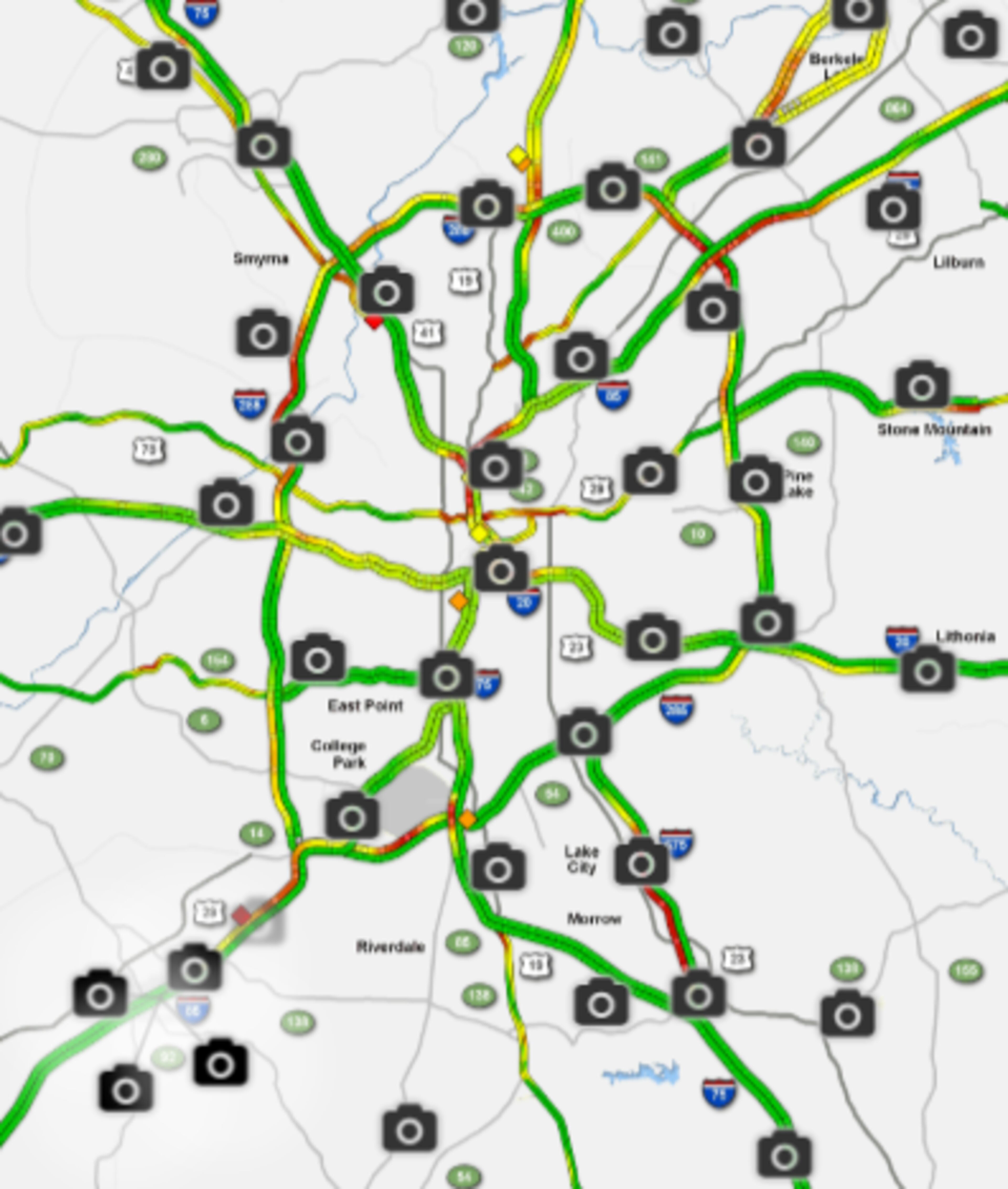
Two right lanes on I-75 South at Mt. Paran Road in Fulton County are blocked by a crash, causing moderate delays, the Traffic Center reported.
Fulton Co: I-75/sb at Mt Paran (exit 256); crash blocking 2 right lanes; delays https://t.co/2hvjWkI3bV #ATLtraffic pic.twitter.com/AHhnYopsQN
— AJC WSB Traffic (@ajcwsbtraffic) September 25, 2018
A left I-20 West lane is blocked by a crash near Hill Street, which is also causing delays, according to the Traffic Center.
Downtown: I-20/wb before Hill St (exit 58B); crash blocking the left lane; delays https://t.co/2hvjWkI3bV #ATLtraffic pic.twitter.com/SCoo7nZD23
— AJC WSB Traffic (@ajcwsbtraffic) September 25, 2018
Construction crews are taking advantage of the break in the rain. Roadwork blocks one right lane on I-675 South at Ga. 138 in Clayton County. In Buckhead, roadwork has shut down one northbound lane of Peachtree Road at Peachtree Memorial Drive.
Fulton Co.; Construction: Peachtree Rd./nb at Peachtree Memorial Dr.; blocks the right lane; delays; https://t.co/RuPa64SzPC; #ATLTraffic pic.twitter.com/NGehNzArES
— Triple Team Traffic (@WSBTraffic) September 25, 2018
Metro Atlanta is seeing overcast skies and has a 40 percent chance of scattered storms. There have been reports of a few spotty showers — and perhaps a rainbow or two — in north Fulton County this afternoon.
Little 🌈 with a shower out in North Fulton. pic.twitter.com/vL8MPBvQcE
— Jason Durden (@JasonDurdenWSB) September 25, 2018
Competing weather systems will keep heavier rain to the west and spotty showers to the east, Channel 2 Action News meteorologist Karen Minton said.
Watching out for scattered showers and isolated storms today... tracking another front with more widespread storms later this week @wsbtv
— Brian Monahan, WSB (@BMonahanWSB) September 25, 2018

She said high pressure wedged in over the Appalachians is expected to keep northeast Georgia cooler with more cloud cover, while a front draped across the west portions of the state is fueling the rain. An additional 1 to 2 inches are expected to fall in the west Tuesday, adding to accumulations of 2 to 3 inches from overnight.
Combination of a wedge of high pressure down the Appalachians, clouds and rain will keep temperatures cooler over NE GA. It will be much warmer SW of Atlanta where afternoon breaks in the clouds allow sunshine to push temps to the upper 80s. pic.twitter.com/Ga6aS12JUx
— Karen Minton (@KarenMintonWSB) September 25, 2018
“That’s going to stir up the activity with some showers and some storms throughout the day,” Minton said. “We’ll see them off and on even in east Georgia, but not as many.”
Temperatures will still be above average. The expected high is 85 degrees in Atlanta, slightly higher than the average temperature of 81.
MOSTLY CLOUDY TODAY: Good morning! We'll have scattered showers and an isolated storm chance today. Plan on a mostly cloudy sky with highs mainly in the low to mid 80s across north Georgia.
— Brian Monahan, WSB (@BMonahanWSB) September 25, 2018
I'm tracking more widespread rain at mid-week. See you at noon! pic.twitter.com/08yFS5VqEk
The next cold front makes it slow trek across the state Wednesday, setting up Thursday to be the coolest day this week with an expected high temperature of 81 degrees.
Looking at the models this morning, overall pattern shift is coming... just taking some time to happen. Either way, the low to mid 90s we saw last week... showing no signs of returning the first week or two of fall.
— Brian Monahan, WSB (@BMonahanWSB) September 25, 2018
“(The front) doesn’t go barreling through,” Minton said. “It’s going to take a little bit of time for it to make some progress and push across the area, but eventually it will slip to our south. It is still going to keep our rain chances higher as we head into (Wednesday) and Thursday before it begins to taper off over the weekend.”
Rain chances jump to 70 percent Wednesday and 80 percent Thursday before dropping slightly to 60 percent Friday.
Another front arrives Wednesday and it will provide more rain for Georgia especially in the NW where drought has been creeping in again. 1-1/2" of rain possible next couple of days pic.twitter.com/RRz1nsPkUu
— Karen Minton (@KarenMintonWSB) September 25, 2018
» For updated traffic information, listen to News 95.5 and AM 750 WSB and follow @ajcwsbtraffic on Twitter.
» Download The Atlanta Journal-Constitution app for weather alerts on-the-go.
About the Authors

Zachary Hansen, a Georgia native, covers economic development and commercial real estate for the AJC. He's been with the newspaper since 2018 and enjoys diving into complex stories that affect people's lives.


