WEATHER-TRAFFIC: Dry but much cooler after deadly storms; 8 tornadoes confirmed
Monday morning brought deadly storms and heavy rain to North Georgia, but Tuesday started out clear and dry — and much cooler, Channel 2 Action News meteorologist Brian Monahan said.
“For the next few days, no storms are in the forecast,” he said. “After that really crazy weather pattern that we saw, things are going to be nice and quiet for us straight through Friday. I’m not expecting any rain across North Georgia, just some cooler temperatures.”
RELATED: 20-year-old among storm victims identified in North Georgia
The National Weather Service has confirmed eight tornadoes touched down in Georgia when a strong cold front swept through the region late Sunday night and early Monday morning. Preliminary data shows that in far North Georgia, EF1 tornadoes hit Dade, Habersham and Walker counties and a significant EF2 tornado tore through Murray County, where seven people in four mobile homes were killed.
RELATED: Overnight storms leave 8 dead, homes destroyed in North Georgia
The Weather Service has also confirmed another EF1 hit Bartow County, where a 34-year-old man was killed when a tree fell on his home as he slept.
The closest tornado to Atlanta was an EF0 in south Fulton County, while Middle Georgia recorded the strongest tornado. An EF3 hit Upson County, which is where a home was lifted off its foundation and dumped onto a road.
MORE: House lands on Georgia road after storm lifts it off foundation
An eighth tornado, registered as an EF1, was also confirmed near Eatonton in Putnam County, according to Channel 2.
Monahan said storm surveys are ongoing.
“These are strong tornadoes, and more are likely going to be confirmed over the next day or so after the National Weather Service continues those storm surveys,” he said.
In addition to the fatalities, the storms destroyed 87 homes, severely damaged 133 and caused 582 more to suffer minor damage, according to the latest information from the Georgia Emergency Management Agency.
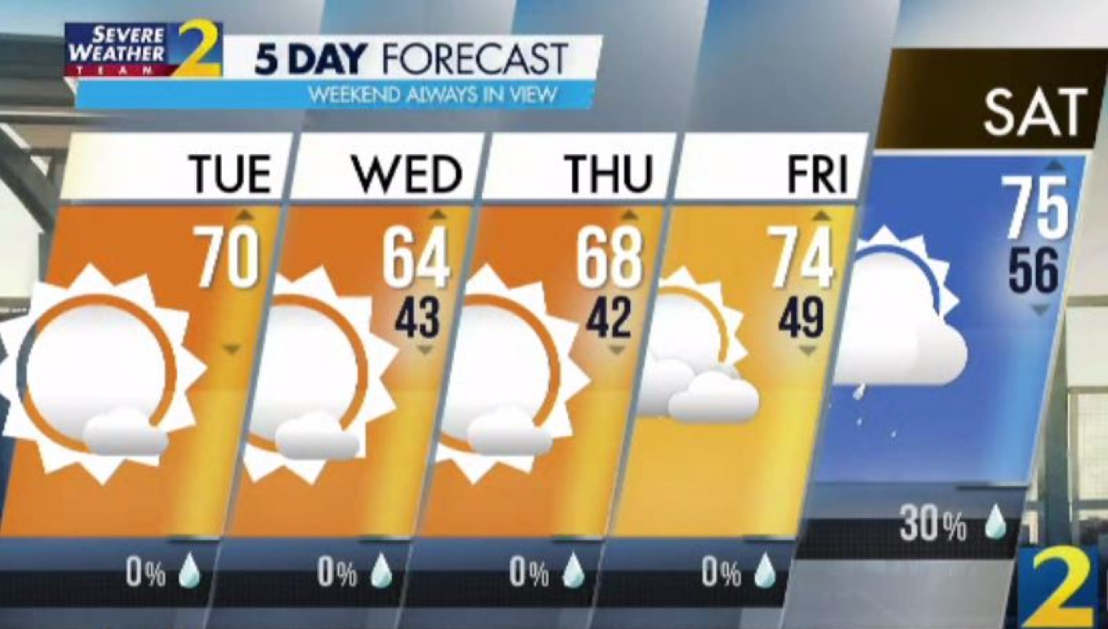
Temperatures started in the 40s and low 50s Tuesday, about 15 to 20 degrees lower than the day before. But metro Atlanta is forecast to return to the low 70s by the afternoon. It was 68 degrees at 5:30 p.m.
That’s a pretty typical afternoon high for this time of year, Monahan said.
“Early spring days usually start kind of cool and they finish kind of warm, and today is going to be one of those days,” he said.
Below-average temperatures in the mid- to upper 60s are in the forecast for Wednesday and Thursday as dry conditions continue, according to Channel 2. Friday’s forecast sees a return to average temps with a low near 50 degrees and a projected high of 74 in Atlanta.
Rain creeps back into the forecast for the weekend, Monahan said. Saturday has a 30% chance, and Sunday’s 40% chance will include a few storms.
“I don’t think it’s what we just went through, but there could be a few storms around to finish the weekend,” he said.
Traffic on the interstates is expected to remain lighter than normal Tuesday with Georgia under a stay-at-home order. Drivers who venture out could experience some delays on surface streets as storm cleanup continues.
» For a detailed forecast, visit The Atlanta Journal-Constitution weather page.
» For updated traffic information, listen to News 95.5 and AM 750 WSB and follow @ajcwsbtraffic on Twitter.
» Download The Atlanta Journal-Constitution app for weather alerts on-the-go.