WEATHER-TRAFFIC UPDATE: West Georgia thunderstorms foreshadow metro’s afternoon
ATLANTA FORECAST
Saturday: High: 90
Saturday night: Low: 71
Sunday: High: 90
» For a detailed forecast, visit The Atlanta Journal-Constitution weather page.
Thunderstorms in Coweta, Carroll and Heard counties foreshadow what’s to come for metro Atlanta.
Channel 2 Action New meteorologist Brian Monahan said these storms exemplify the type of storms Atlanta and east Georgia can expect this afternoon – slow moving with heavy rain.
Severe Thunderstorm Warning for Southeastern Carroll, Northern Heard, Western Coweta County Until 245 PM for 60 mph winds pic.twitter.com/P4l83pUK2O
— Katie Walls (@KatieWallsWSB) June 9, 2018
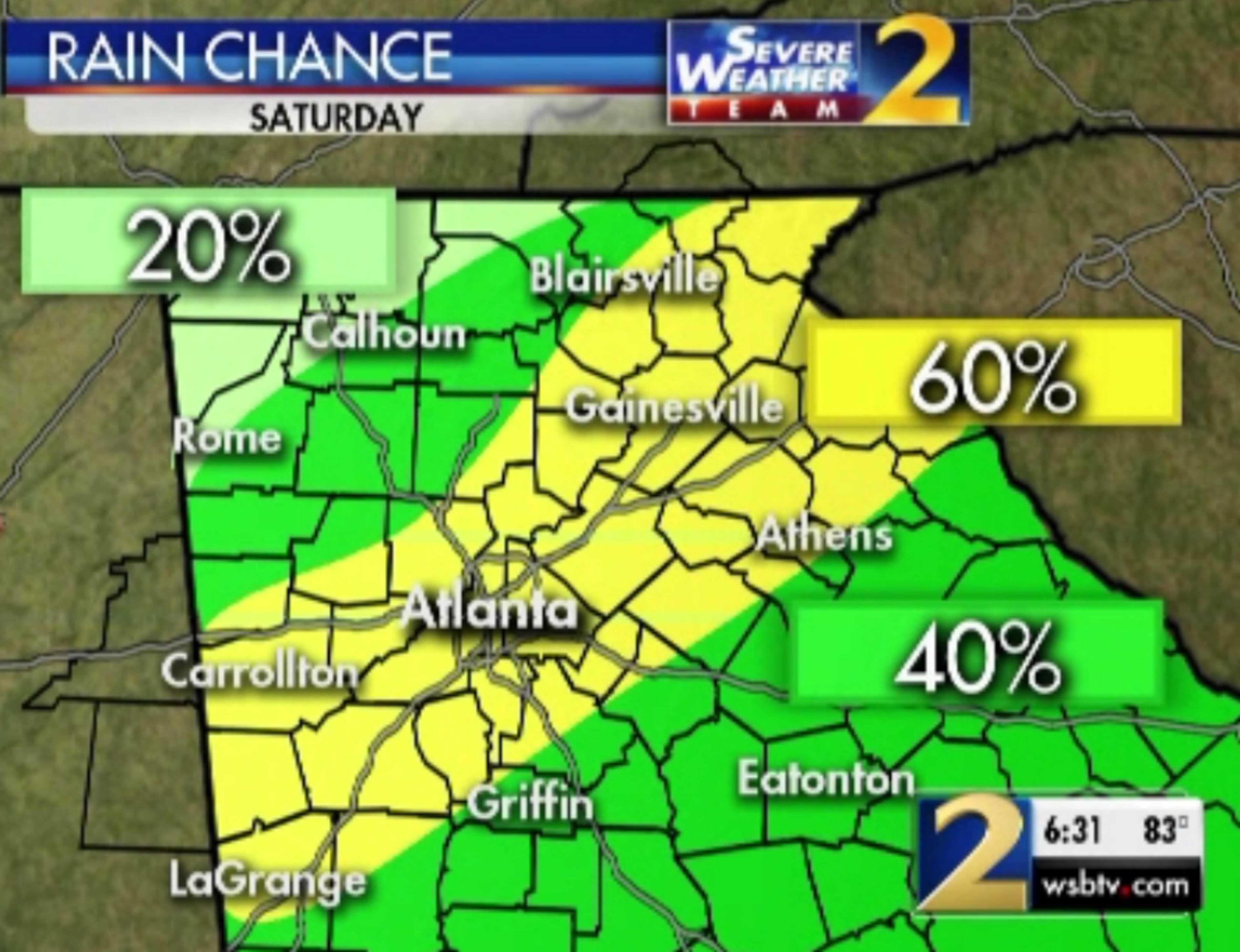
The predicted chance of rain for Saturday is 60 percent for a large stripe of Georgia, including most of metro Atlanta. The area runs from LaGrange and Carrollton though Gainesville and Athens all the way to the South Carolina state line.
Middle Georgia and other areas of North Georgia have a 40 percent chance of rain, Monahan said.
"Not everyone will see the rain, but where we do – frequent lightning, heavy rains and gusty winds will be our threats,” Channel 2 meteorologist Brian Monahan said.
Storms becoming more likely as the day goes on today -- up to a 60% rain chance by day's end. Temperatures push into the mid to upper 80s! @wsbtv pic.twitter.com/ROF6mDpPDQ
— Brian Monahan, WSB (@BMonahanWSB) June 9, 2018
However, everyone on I-285 near Jonesboro Road are seeing lots of traffic.
Construction on four left lanes on I-285 at Jonesboro Road has slowed traffic to a crawl in both directions, according to the WSB 24-hour Traffic Center.
"Not moving" is how these delays are being described. The DOT is working in the 4 left lanes of I-285 BOTH directions near Jonesboro Rd, exit 55. AVOID THAT AREA! pic.twitter.com/yVTcoYffNZ
— AJC WSB Traffic (@ajcwsbtraffic) June 9, 2018
It’s currently 87 degrees, but the predicted high is 90 degrees, which should fuel the heaviest storms this afternoon, Monahan said.
Monahan said the storms are expected to bring a lot of rain and lightning, while moving very slowly.
"These storms are just going to drift,” Monahan said. “They're not going to move very much, so where they set up, it'll be heavy rain that will continue for an extended period of time."
As storms develop later today, they will gradually drift toward the south and west... very slow-moving again. Main impacts will be heavy rain, frequent lightning, and strong wind gusts. @wsbtv
— Brian Monahan, WSB (@BMonahanWSB) June 9, 2018
The line of thunderstorms should envelop the state this afternoon until fading away around 8 p.m., Monahan said.
There is a 40 to 60 percent chance of rain every day until Wednesday. Temperatures should hover in the upper 80s during the day and low 70s at night, Burns said.
Start spreading the news...#BelmontStakes150 🗽 pic.twitter.com/r8cqU7wOlL
— Belmont Stakes (@BelmontStakes) June 5, 2018
If you’re considering going to Lake Lanier, Monahan said to expect rain nearby. The good news is the lake is about a foot lower than it was last week, but he said it’s still 2.5 feet above full pool. Just make sure to be careful and safe out on the water.
Scattered showers & storms around Lake Lanier today. Lake level is down to 2.5 feet above full pool -- last week it was at 3.5 feet. Controlled releases continue at Buford Dam. @wsbtv pic.twitter.com/JZSxmZY6x7
— Brian Monahan, WSB (@BMonahanWSB) June 9, 2018
But if you’re more of an indoors person, watching the Belmont Stakes might be up your alley. Since Justify is a triple crown contender, roadways may get crowded near local sports bars.
» For a closer look at the weekend outlook and things to do in your area:
Atlanta | Cobb | DeKalb | Gwinnett | North Fulton
» For updated traffic information, listen to News 95.5 and AM 750 WSB and follow @ajcwsbtraffic on Twitter.
» Download The Atlanta Journal-Constitution app for weather alerts on-the-go.
About the Author

Zachary Hansen, a Georgia native, covers economic development and commercial real estate for the AJC. He's been with the newspaper since 2018 and enjoys diving into complex stories that affect people's lives.

