WEATHER-TRAFFIC UPDATE: Atlanta reaches near-record 84 degrees
ATLANTA FORECAST
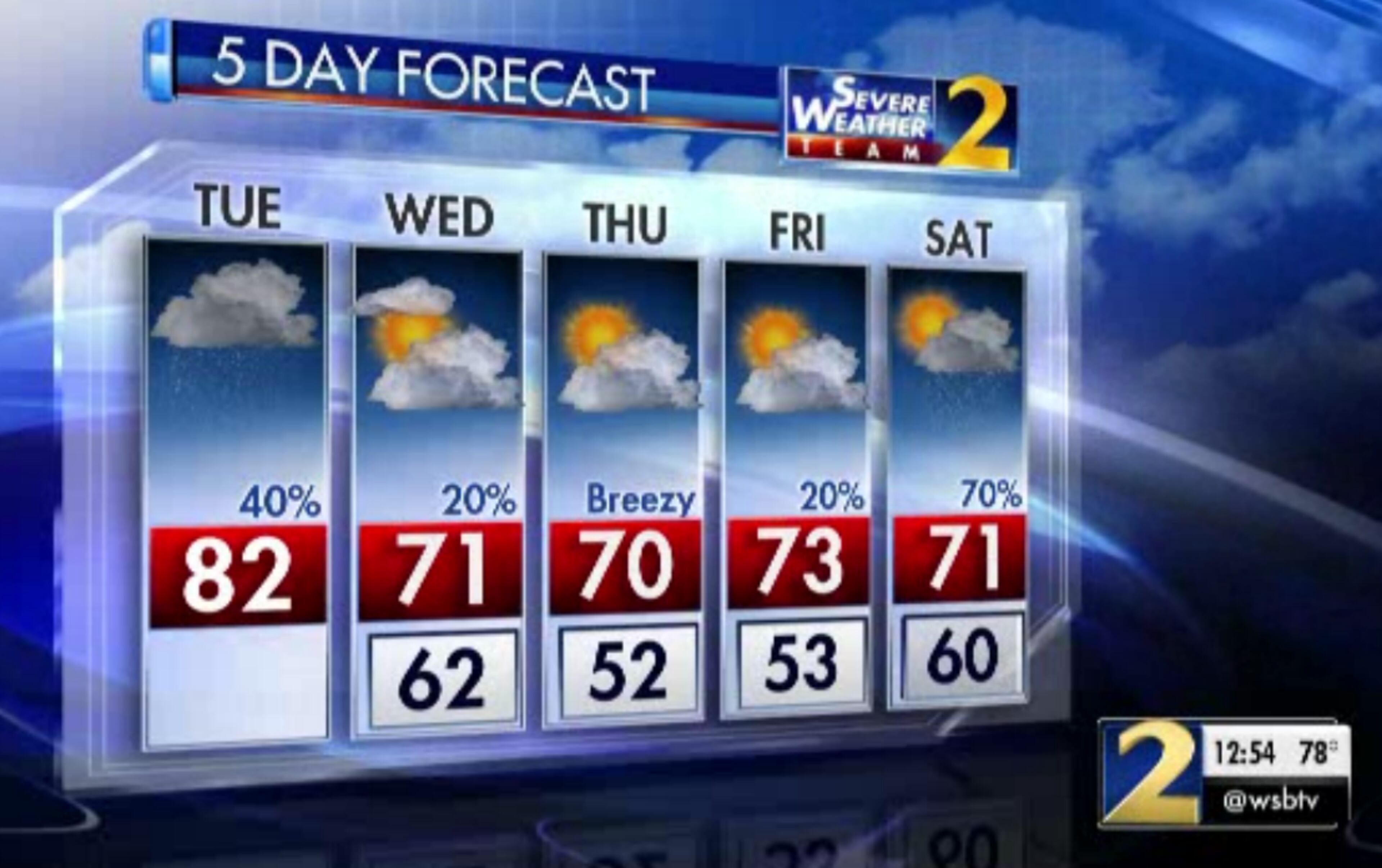
Tuesday: High: 82
Tuesday night: Low: 62
Wednesday: High: 71
» For a detailed forecast, visit The Atlanta Journal-Constitution weather page.
The Atlanta heat nearly tied a record this afternoon when temperatures reached 84 degrees, Channel 2 Action News meteorologist Brad Nitz said. The record high was 85 degrees set in 1941.
Temperatures remained in the 60s across much of far north Georgia with rain today. Atlanta hit 84° today (just one degree shy of the record). Our average high is 73°.
— Brad Nitz (@BradNitzWSB) October 16, 2018
We're going to get much cooler in the days ahead. The time line live on @wsbtv at 5pm. pic.twitter.com/tlb5DGGi7c
All the while, traffic has increased on metro Atlanta's interstates as the evening commute begins, according to the WSB 24-hour Traffic Center.
Gwinnett County is faring better than this morning, but congestion is increasing. Around 10 a.m., a box truck overturned on I-85 South past Jimmy Carter Boulevard. The crash involved six other vehicles, according to the Georgia State Patrol. Two people were taken to a hospital. Their conditions have not been released.
Authorities at times blocked all southbound lanes, and northbound traffic in the HOT lanes was also impacted, the reported. The crash was cleared and the interstate reopened about 12:30 p.m.
TRAVEL ADVISORY: Gwinnett Co.; Truck Crash Cleared: I-85/sb past Jimmy Carter Blvd; (exit 99); All Lanes are Now Open; heavys delays remain; https://t.co/RuPa64SzPC; #atltraffic pic.twitter.com/dZObE8w6j0
— Triple Team Traffic (@WSBTraffic) October 16, 2018
In Fulton County, two southbound Downtown Connector lanes are blocked near Martin Luther King Jr. Drive because of a wreck, the Traffic Center reported.
TRAVEL ADVISORY Fulton Co: Crash; I-75/85/sb at MLK Jr Dr(Exit 247); two center lanes; delays https://t.co/oChLshdbT4 #ATLTraffic pic.twitter.com/BLDR7iU2vy
— AJC WSB Traffic (@ajcwsbtraffic) October 16, 2018
Rain is moving into northwest Georgia this afternoon, and more showers are expected through the evening. Despite the showers, Atlanta is still way hotter than normal. The average high for this date is 73 degrees.
I'm tracking rain and cool air headed our way. Right now on @wsbtv. pic.twitter.com/2yIpJC6aZC
— Brad Nitz (@BradNitzWSB) October 16, 2018
Channel 2 Action News meteorologist Brian Monahan said the mountain counties will see the best chance of more widespread showers Tuesday. There’s a 60 percent chance of rain up north, he said, with a 40 percent chance for metro Atlanta.
The Southside should stay drier with a 20 percent chance of rain, according to Channel 2.
TUESDAY RAIN OUTLOOK: Good morning! Most of the rain we see today will be on the light side -- with the highest chance across the north Georgia mountains.
— Brian Monahan, WSB (@BMonahanWSB) October 16, 2018
I'm tracking when today's slow-moving front passes by -- now to 7am on Channel 2! @wsbtv pic.twitter.com/R7st34stfU
“The farther north you live of Atlanta, the better your chance of seeing showers today,” Monahan said.
Still, rainfall should be on the light side, he said, “a half-inch or less even in some spots that will see more widespread rain.”
Rainfall amounts today will all be generally on the light side -- a half inch or less even in spots that see more widespread rain (mountains).
— Brian Monahan, WSB (@BMonahanWSB) October 16, 2018
I'm timing when we clear back out -- at 5:19am on Channel 2! @wsbtv pic.twitter.com/fR5Nl8Uv9M
The cloud cover is thanks to a cold front that made its way into the state Monday night, according to Channel 2. The front will continue to move south Tuesday, and Monahan said North Georgia will dry out as it moves farther away.
Cooler air will start pouring into north Georgia later today and into tomorrow -- where many spots will stay in the low 70s for highs!
— Brian Monahan, WSB (@BMonahanWSB) October 16, 2018
By Thursday morning, we'll have lows in the 40s in many spots.
On @wsbtv app live now through 9am. pic.twitter.com/9JGwS1CLPN
“The weekend won’t be a washout, though,” Monahan said. “We’ll get that front on by. It will turn mostly sunny, cooler on Sunday with highs in the 60s.”
» For updated traffic information, listen to News 95.5 and AM 750 WSB and follow @ajcwsbtraffic on Twitter.
» Download The Atlanta Journal-Constitution app for weather alerts on-the-go.
About the Authors


Zachary Hansen, a Georgia native, covers economic development and commercial real estate for the AJC. He's been with the newspaper since 2018 and enjoys diving into complex stories that affect people's lives.